

- PHOTOS:
- Dec 16, 2008 - May 21, 2009
- Mar 17, 2008 - Dec 15, 2008
- Nov 01, 2007 - Mar 16, 2008
- Our SC35 Sailboat: PRUDENCE
- SELECTED BLOGS
- Jan'05: The Idea
- May'05: First Cruise - Belize
- Aug'05: Buying Ashiya
- Oct'05: School in St. Vincent
- Nov'05: Ocracoke on Ashiya
- Jul'06: Long Trip on Ashiya
- Oct'06: Prudence Comes Home
- Nov'07: First Night Offshore
- Nov'07: Offshore Take Two
- Nov'07: Gulf Stream Crossing
- Dec'07: Green Turtle Cay
- Dec'07: Lynyard Cay
- Dec'07: Warderick Wells Cay
- Jan'08: George Town
- Jan'08: Life without a Fridge
- Jan'08: Mayaguana Island
- Jan'08: Turks & Caicos
- Jan'08: Dominican Republic
- Jan'08: Down the Waterfalls
- Feb'08: Puerto Rico
- Feb'08: Starter Troubles
- Feb'08: Vieques
- Mar'08: Finally Sailing Again
- Mar'08: Trip So Far
- Mar'08: Hiking Culebra
- Mar'08: Kayak & Snorkel I
- Mar'08: Teak and Waterspouts
- Mar'08: Kayak & Snorkel II
- Mar'08: Bottom Cleaning
- Apr'08: Culebra Social Life
- Apr'08: Culebra Routine
- Apr'08: Culebra Beaches
- Apr'08: Culebrita
- Jun'08: Kayak & Snorkel III
- Jun'08: Kayak & Snorkel IV
- Jun'08: Manta Ray
- Jun'08: Sea Turtles
- Jul'08: Cost of Cruising
- Jul'08: Busy Week in Culebra
- Jul'08: Getting to Land
- Jul'08: Leatherback Boil
- Jul'08: Fish and Volcano Dust
- Aug'08: Teaching Algebra
- Sep'08: Culebra Card Club
- Oct'08: Kayak & Snorkel V
- Oct'08: Prep for Hurricane
- Oct'08: Hurricane Omar
- Oct'08: Fish and Sea Glass
- Oct'08: Waterspouts
- Dec'08: Hurricane Season Ends
- Dec'08: Culebra to St. Martin
- Jan'09: Antigua Part 1
- Feb'09: The Saints
- Feb'09: Visiting Dominica
- Mar'09: Antigua Part 2
- Apr'09: Antigua to Bermuda
- May'09: Bermuda to Norfolk
- FULL LIST of Blog Entries
SailBlogs Friends


15 July 2009
14 July 2009
15 June 2009
14 June 2009 | Annapolis, MD
13 June 2009
12 June 2009
11 June 2009
10 June 2009 | Little Creek Marina, Norfolk, VA, USA
04 June 2009 | Little Creek Marina, Norfolk, VA, USA
31 May 2009 | Little Creek Marina, Norfolk, VA, USA
29 May 2009 | Little Creek Marina, Norfolk, VA, USA
26 May 2009 | Little Creek Marina, Norfolk, VA, USA
25 May 2009 | Little Creek Marina, Norfolk, VA, USA
13 May 2009 | through 21-May-2009
13 May 2009 | through 21-May-2009
12 May 2009 | St George's Town, Bermuda
11 May 2009 | St George's Town, Bermuda
07 May 2009 | St George's Town, Bermuda
04 May 2009 | St George's Town, Bermuda
21 April 2009 | through 02-May-2009
We Finally Go to Lower Lattitudes
19 December 2007 | From the Abacos to the Exumas, Bahamas
CURRENT LOCATION: Anchored on west side of Highborne Cay, Exumas, Bahamas
24 42.716' N, 076 49.782' W (CLICK HERE for Google Maps)
The cold front blew through on schedule, and the Fortress took up the load, just as we had planned. We spent the next two days reading and relaxing in the slightly cooler air carried in by the northerly winds which followed the front. Word from others here, via the VHF radio, is that it is downright cold! However, with national news reports (on AM radio) indicating temperatures in the teens in the Carolinas, we are quite happy with the current highs in the low 70s and lows in the high 60s. (Note: prior to today, we had seen highs in the mid 80s and lows in the high 70s)
The only chores we focused upon for the two days following the cold front were related to preparations for going to the Exumas. We dried and deflated the kayaks, swam out and collected all the spare anchors, entered waypoints for the trip south into the GPS, and baked a few loaves of bread (wheat bread for sandwiches, spicy garlic bread to go with dinners, and cinnamon raisin to enjoy with a cup of coffee).
Our departure (on Tuesday, Dec 18th) was timed to have us heading out the North Bar Channel at the end of an incoming tide (because wind against current would be a very bad mix), and to approximate our arrival in the Nassau area at daybreak. We were motoring-sailing through the channel by 2PM.
The challenge to finding the 'right' weather window for this trip was in meeting all of three criteria: 1) we had to have conditions suitable for exiting the channel from the shallow Sea of Abaco to the deep Atlantic Ocean; 2) we wanted to have winds which would allow us to sail, not motor, the longest stretch of the passage, across the Atlantic's Northwest Providence Channel; 3) the winds and sea state had to be just right to sail from Nassau to the Exumas over the coral-strewn Yellow Banks, as sunlight and reasonably calm seas are required to spot and avoid the coral.
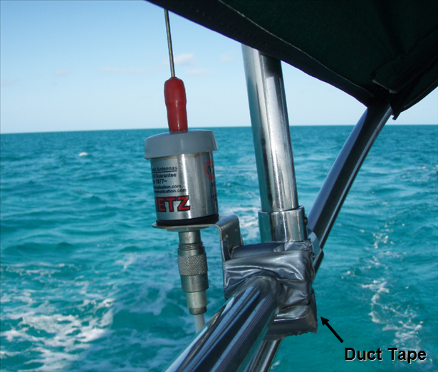
Although we believed that we had selected weather conditions which struck a good balance between these three criteria, the trip out the North Bar Channel was still a nail biter. With Sheryl as navigator and me at the helm, we maneuvered through the big NE swell. It was a good thing we had not tried to exit last week when an even larger eastern swell bore down on this east-facing channel. By the time we were about five nautical miles offshore, we breathed a sigh of relief at having jumped the first hurdle of this passage and gained the relative safety of deep water. Only one casualty was noted at this point in the journey. The bracket holding our SSB radio antenna had snapped in two, leaving it dangling from our bimini rail. The waves in the inlet must have had the antenna really bouncing to cause this crack. Sheryl affected a temporary repair with duct tape.
So far, since departing North Carolina, we have been very fortunate (knock on wood) relative to the function of the boat and all of our equipment. With the exception of this plastic antenna rail mounting, the only other equipment malfunction which has plagued us is our WiFi internet signal booster (it no longer works at all, and the manufacturer, Port Networks, has yet to return the e-mail we sent nearly 3 weeks ago). I suppose, dear Reader, you can blame them for our infrequent blog postings and response to your e-mails. [Your complaints regarding this situation can be sent directly to sales@portnetworks.com. Please use our name and tell them that a dissatisfied customer is planning to spread the word among the cruising community, their primary customer base, about their poor customer service. Perhaps enough of your e-mails will encourage them to respond to ours.] That is it for the non-working category, though. Oh yes, there was that problem with the autohelm compass, but a few taps with a hammer (delivered as we first entered Bahamian waters), and we have had no problems since. The spare compass we had shipped to Stuart, FL remains in its packaging.
The second hurdle of our passage was the overnight crossing of the Northwest Providence Channel. The winds were perfect (12-20 knots) off our port quarter for the entire 75-nautical mile rhum line course. The seas, however, were a little larger than we might have desired. The swell, also from the port quarter, caused Prudence to undergo the same swaying motion we experienced during our very first night at sea, after heading out Beaufort Inlet. This was not good.
Although the sailing, itself, was excellent and the engine was never once enlisted during the ocean crossing, this part of the passage was still quite stressful. Between monitoring big boat traffic (many cruise ships frequent Nassau), dodging a rather scary-looking squall (backlit by moonbeams, making it appear all the more ominous), and Sheryl suffering from a substantial bout of 'inner ear disturbance,' neither of us found any sleep this night. Sheryl attempted sleep by curling up into the fetal position on the floor of our cockpit, as going below in her condition was simply not an option. Any sleep she got was short-lived, as big boats and a bumpy ride shortly shook her awake. Early in the evening, I spent a grand total of about one hour below with my eyes closed, held in place by a lee cloth. Unfortunately, sleep would not come.
We arrived off of Nassau just prior to dawn, bleary eyed and fatigued. Fortunately, our timing and control of our speed throughout the night (we had adjusted sail to keep us a little slower than we otherwise could have gone) allowed us to approach land just as the sun peeked over the horizon. Sheryl, much recovered with the return of daylight, took the helm while I navigated. The NE swell presented a bit of a challenge as we approached the cut through Rose Island Rocks. This was our point of entry onto the shallows of the Great Bahama Bank from the Atlantic. The transition was startlingly evident. A distinct line formed between the two tips of land where the seas immediately went from 4-5 foot waves to flat calm. On the two points of land, the waves were crashing, framing our approach with considerable dramatic effect. Sheryl calmly controlled the boat as she surfed the waves up to and through the narrow cut.
As the sun rose in the sky, we sailed toward our third, and final, hurdle of this passage: the crossing of the Yellow Bank. This route is littered with coral heads, some of which are reported to be shallower than our 1.5-meter draft. Some cruisers we spoke with downplayed the threat of the coral, saying that they were, "deeper than the charts would suggest." We, however, have grown to respect our Explorer charts, and when they suggest VPR (which stands for Visual Piloting Rules), that is exactly what we do. Combining the chart information with a suggestion we found in our guide book, we altered our course to run due south from Rose Island until we reached a point between White Bank and Yellow Bank, then turned east. The guidebook suggested that this route would have fewer coral heads, and the chart was in agreement.
The course turned out to be a good one, and with the sun's midday light directly overhead, we sailed on a brisk close reach eastward toward our anchoring destination. Throughout the coral-containing region, one of us stayed on the bow, spotting coral heads (which appeared as dark brown patches on a background of turquoise water), and pointing directions for the helmsman. The 6-7 knot pace of the boat over some wind-driven chop gave us a rush of excitement that kept us awake and alert. The bouncing at the bow even helped Sheryl get a little higher view at the peak of each oscillation.
By the time we reached the anchorage, though, one of us (namely me) was totally spent. We dropped the hook in 5 meters of water off of Highborne Cay, and the holding (as recommended by the Explorer chart) was good. Sheryl and I both dove on the anchor to be sure. We also wanted to take a quick look at a few of the dark brown patches from an underwater perspective, and there were several near our anchor spot.
As much as we had enjoyed the Abacos, first impressions would suggest that the water here in the Exumas is even clearer! The fish around the coral heads we investigated appeared crisp and vibrant in their many colors, even when viewed through over 15 feet of water. Sitting on the boat, just after sunset, with the moonlight causing the clear water surrounding the boat to glow, it looked like a swimming pool at night. It was so beautiful it almost made us forget how tired we were. Almost, I repeat, for sleep was upon us by 7PM.
24 42.716' N, 076 49.782' W (CLICK HERE for Google Maps)
The cold front blew through on schedule, and the Fortress took up the load, just as we had planned. We spent the next two days reading and relaxing in the slightly cooler air carried in by the northerly winds which followed the front. Word from others here, via the VHF radio, is that it is downright cold! However, with national news reports (on AM radio) indicating temperatures in the teens in the Carolinas, we are quite happy with the current highs in the low 70s and lows in the high 60s. (Note: prior to today, we had seen highs in the mid 80s and lows in the high 70s)
The only chores we focused upon for the two days following the cold front were related to preparations for going to the Exumas. We dried and deflated the kayaks, swam out and collected all the spare anchors, entered waypoints for the trip south into the GPS, and baked a few loaves of bread (wheat bread for sandwiches, spicy garlic bread to go with dinners, and cinnamon raisin to enjoy with a cup of coffee).
Our departure (on Tuesday, Dec 18th) was timed to have us heading out the North Bar Channel at the end of an incoming tide (because wind against current would be a very bad mix), and to approximate our arrival in the Nassau area at daybreak. We were motoring-sailing through the channel by 2PM.
The challenge to finding the 'right' weather window for this trip was in meeting all of three criteria: 1) we had to have conditions suitable for exiting the channel from the shallow Sea of Abaco to the deep Atlantic Ocean; 2) we wanted to have winds which would allow us to sail, not motor, the longest stretch of the passage, across the Atlantic's Northwest Providence Channel; 3) the winds and sea state had to be just right to sail from Nassau to the Exumas over the coral-strewn Yellow Banks, as sunlight and reasonably calm seas are required to spot and avoid the coral.
Although we believed that we had selected weather conditions which struck a good balance between these three criteria, the trip out the North Bar Channel was still a nail biter. With Sheryl as navigator and me at the helm, we maneuvered through the big NE swell. It was a good thing we had not tried to exit last week when an even larger eastern swell bore down on this east-facing channel. By the time we were about five nautical miles offshore, we breathed a sigh of relief at having jumped the first hurdle of this passage and gained the relative safety of deep water. Only one casualty was noted at this point in the journey. The bracket holding our SSB radio antenna had snapped in two, leaving it dangling from our bimini rail. The waves in the inlet must have had the antenna really bouncing to cause this crack. Sheryl affected a temporary repair with duct tape.
So far, since departing North Carolina, we have been very fortunate (knock on wood) relative to the function of the boat and all of our equipment. With the exception of this plastic antenna rail mounting, the only other equipment malfunction which has plagued us is our WiFi internet signal booster (it no longer works at all, and the manufacturer, Port Networks, has yet to return the e-mail we sent nearly 3 weeks ago). I suppose, dear Reader, you can blame them for our infrequent blog postings and response to your e-mails. [Your complaints regarding this situation can be sent directly to sales@portnetworks.com. Please use our name and tell them that a dissatisfied customer is planning to spread the word among the cruising community, their primary customer base, about their poor customer service. Perhaps enough of your e-mails will encourage them to respond to ours.] That is it for the non-working category, though. Oh yes, there was that problem with the autohelm compass, but a few taps with a hammer (delivered as we first entered Bahamian waters), and we have had no problems since. The spare compass we had shipped to Stuart, FL remains in its packaging.
The second hurdle of our passage was the overnight crossing of the Northwest Providence Channel. The winds were perfect (12-20 knots) off our port quarter for the entire 75-nautical mile rhum line course. The seas, however, were a little larger than we might have desired. The swell, also from the port quarter, caused Prudence to undergo the same swaying motion we experienced during our very first night at sea, after heading out Beaufort Inlet. This was not good.
Although the sailing, itself, was excellent and the engine was never once enlisted during the ocean crossing, this part of the passage was still quite stressful. Between monitoring big boat traffic (many cruise ships frequent Nassau), dodging a rather scary-looking squall (backlit by moonbeams, making it appear all the more ominous), and Sheryl suffering from a substantial bout of 'inner ear disturbance,' neither of us found any sleep this night. Sheryl attempted sleep by curling up into the fetal position on the floor of our cockpit, as going below in her condition was simply not an option. Any sleep she got was short-lived, as big boats and a bumpy ride shortly shook her awake. Early in the evening, I spent a grand total of about one hour below with my eyes closed, held in place by a lee cloth. Unfortunately, sleep would not come.
We arrived off of Nassau just prior to dawn, bleary eyed and fatigued. Fortunately, our timing and control of our speed throughout the night (we had adjusted sail to keep us a little slower than we otherwise could have gone) allowed us to approach land just as the sun peeked over the horizon. Sheryl, much recovered with the return of daylight, took the helm while I navigated. The NE swell presented a bit of a challenge as we approached the cut through Rose Island Rocks. This was our point of entry onto the shallows of the Great Bahama Bank from the Atlantic. The transition was startlingly evident. A distinct line formed between the two tips of land where the seas immediately went from 4-5 foot waves to flat calm. On the two points of land, the waves were crashing, framing our approach with considerable dramatic effect. Sheryl calmly controlled the boat as she surfed the waves up to and through the narrow cut.
As the sun rose in the sky, we sailed toward our third, and final, hurdle of this passage: the crossing of the Yellow Bank. This route is littered with coral heads, some of which are reported to be shallower than our 1.5-meter draft. Some cruisers we spoke with downplayed the threat of the coral, saying that they were, "deeper than the charts would suggest." We, however, have grown to respect our Explorer charts, and when they suggest VPR (which stands for Visual Piloting Rules), that is exactly what we do. Combining the chart information with a suggestion we found in our guide book, we altered our course to run due south from Rose Island until we reached a point between White Bank and Yellow Bank, then turned east. The guidebook suggested that this route would have fewer coral heads, and the chart was in agreement.
The course turned out to be a good one, and with the sun's midday light directly overhead, we sailed on a brisk close reach eastward toward our anchoring destination. Throughout the coral-containing region, one of us stayed on the bow, spotting coral heads (which appeared as dark brown patches on a background of turquoise water), and pointing directions for the helmsman. The 6-7 knot pace of the boat over some wind-driven chop gave us a rush of excitement that kept us awake and alert. The bouncing at the bow even helped Sheryl get a little higher view at the peak of each oscillation.
By the time we reached the anchorage, though, one of us (namely me) was totally spent. We dropped the hook in 5 meters of water off of Highborne Cay, and the holding (as recommended by the Explorer chart) was good. Sheryl and I both dove on the anchor to be sure. We also wanted to take a quick look at a few of the dark brown patches from an underwater perspective, and there were several near our anchor spot.
As much as we had enjoyed the Abacos, first impressions would suggest that the water here in the Exumas is even clearer! The fish around the coral heads we investigated appeared crisp and vibrant in their many colors, even when viewed through over 15 feet of water. Sitting on the boat, just after sunset, with the moonlight causing the clear water surrounding the boat to glow, it looked like a swimming pool at night. It was so beautiful it almost made us forget how tired we were. Almost, I repeat, for sleep was upon us by 7PM.
| Vessel Name: | Prudence |
| About: |
Gallery not available
- PHOTOS:
- Dec 16, 2008 - May 21, 2009
- Mar 17, 2008 - Dec 15, 2008
- Nov 01, 2007 - Mar 16, 2008
- Our SC35 Sailboat: PRUDENCE
- SELECTED BLOGS
- Jan'05: The Idea
- May'05: First Cruise - Belize
- Aug'05: Buying Ashiya
- Oct'05: School in St. Vincent
- Nov'05: Ocracoke on Ashiya
- Jul'06: Long Trip on Ashiya
- Oct'06: Prudence Comes Home
- Nov'07: First Night Offshore
- Nov'07: Offshore Take Two
- Nov'07: Gulf Stream Crossing
- Dec'07: Green Turtle Cay
- Dec'07: Lynyard Cay
- Dec'07: Warderick Wells Cay
- Jan'08: George Town
- Jan'08: Life without a Fridge
- Jan'08: Mayaguana Island
- Jan'08: Turks & Caicos
- Jan'08: Dominican Republic
- Jan'08: Down the Waterfalls
- Feb'08: Puerto Rico
- Feb'08: Starter Troubles
- Feb'08: Vieques
- Mar'08: Finally Sailing Again
- Mar'08: Trip So Far
- Mar'08: Hiking Culebra
- Mar'08: Kayak & Snorkel I
- Mar'08: Teak and Waterspouts
- Mar'08: Kayak & Snorkel II
- Mar'08: Bottom Cleaning
- Apr'08: Culebra Social Life
- Apr'08: Culebra Routine
- Apr'08: Culebra Beaches
- Apr'08: Culebrita
- Jun'08: Kayak & Snorkel III
- Jun'08: Kayak & Snorkel IV
- Jun'08: Manta Ray
- Jun'08: Sea Turtles
- Jul'08: Cost of Cruising
- Jul'08: Busy Week in Culebra
- Jul'08: Getting to Land
- Jul'08: Leatherback Boil
- Jul'08: Fish and Volcano Dust
- Aug'08: Teaching Algebra
- Sep'08: Culebra Card Club
- Oct'08: Kayak & Snorkel V
- Oct'08: Prep for Hurricane
- Oct'08: Hurricane Omar
- Oct'08: Fish and Sea Glass
- Oct'08: Waterspouts
- Dec'08: Hurricane Season Ends
- Dec'08: Culebra to St. Martin
- Jan'09: Antigua Part 1
- Feb'09: The Saints
- Feb'09: Visiting Dominica
- Mar'09: Antigua Part 2
- Apr'09: Antigua to Bermuda
- May'09: Bermuda to Norfolk
- FULL LIST of Blog Entries
SailBlogs Friends