

- PHOTOS:
- Dec 16, 2008 - May 21, 2009
- Mar 17, 2008 - Dec 15, 2008
- Nov 01, 2007 - Mar 16, 2008
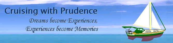
- Our SC35 Sailboat: PRUDENCE
- SELECTED BLOGS
- Jan'05: The Idea
- May'05: First Cruise - Belize
- Aug'05: Buying Ashiya
- Oct'05: School in St. Vincent
- Nov'05: Ocracoke on Ashiya
- Jul'06: Long Trip on Ashiya
- Oct'06: Prudence Comes Home
- Nov'07: First Night Offshore
- Nov'07: Offshore Take Two
- Nov'07: Gulf Stream Crossing
- Dec'07: Green Turtle Cay
- Dec'07: Lynyard Cay
- Dec'07: Warderick Wells Cay
- Jan'08: George Town
- Jan'08: Life without a Fridge
- Jan'08: Mayaguana Island
- Jan'08: Turks & Caicos
- Jan'08: Dominican Republic
- Jan'08: Down the Waterfalls
- Feb'08: Puerto Rico
- Feb'08: Starter Troubles
- Feb'08: Vieques
- Mar'08: Finally Sailing Again
- Mar'08: Trip So Far
- Mar'08: Hiking Culebra
- Mar'08: Kayak & Snorkel I
- Mar'08: Teak and Waterspouts
- Mar'08: Kayak & Snorkel II
- Mar'08: Bottom Cleaning
- Apr'08: Culebra Social Life
- Apr'08: Culebra Routine
- Apr'08: Culebra Beaches
- Apr'08: Culebrita
- Jun'08: Kayak & Snorkel III
- Jun'08: Kayak & Snorkel IV
- Jun'08: Manta Ray
- Jun'08: Sea Turtles
- Jul'08: Cost of Cruising
- Jul'08: Busy Week in Culebra
- Jul'08: Getting to Land
- Jul'08: Leatherback Boil
- Jul'08: Fish and Volcano Dust
- Aug'08: Teaching Algebra
- Sep'08: Culebra Card Club
- Oct'08: Kayak & Snorkel V
- Oct'08: Prep for Hurricane
- Oct'08: Hurricane Omar
- Oct'08: Fish and Sea Glass
- Oct'08: Waterspouts
- Dec'08: Hurricane Season Ends
- Dec'08: Culebra to St. Martin
- Jan'09: Antigua Part 1
- Feb'09: The Saints
- Feb'09: Visiting Dominica
- Mar'09: Antigua Part 2
- Apr'09: Antigua to Bermuda
- May'09: Bermuda to Norfolk
- FULL LIST of Blog Entries
SailBlogs Friends


15 July 2009
14 July 2009
15 June 2009
14 June 2009 | Annapolis, MD
13 June 2009
12 June 2009
11 June 2009
10 June 2009 | Little Creek Marina, Norfolk, VA, USA
04 June 2009 | Little Creek Marina, Norfolk, VA, USA
31 May 2009 | Little Creek Marina, Norfolk, VA, USA
29 May 2009 | Little Creek Marina, Norfolk, VA, USA
26 May 2009 | Little Creek Marina, Norfolk, VA, USA
25 May 2009 | Little Creek Marina, Norfolk, VA, USA
13 May 2009 | through 21-May-2009
13 May 2009 | through 21-May-2009
12 May 2009 | St George's Town, Bermuda
11 May 2009 | St George's Town, Bermuda
07 May 2009 | St George's Town, Bermuda
04 May 2009 | St George's Town, Bermuda
21 April 2009 | through 02-May-2009
Circumnavigating Warderick Wells Cay and Other Explorations
22 December 2007 | Warderick Wells Cay, Exumas, Bahamas
CURRENT LOCATION: On a mooring ball at Warderick Wells Cay, Exuma Cays Land & Sea Park, Exumas, Bahamas
24 23.711' N, 076 38.141' W (CLICK HERE for Google Maps)
In addition to the natural splendor which I will try to relate below, the Exuma Cays Land & Sea Park, here on Warderick Wells Cay, also offers internet access ($10/day). Since we can see the WiFi signal with our internal laptop card (read: no booster required), we signed up for 24-hours of internet the moment we arrived here. Consequently, Sheryl and I had a late night uploading pictures, updating the blog site, and responding to e-mail. Another late night among many this week.
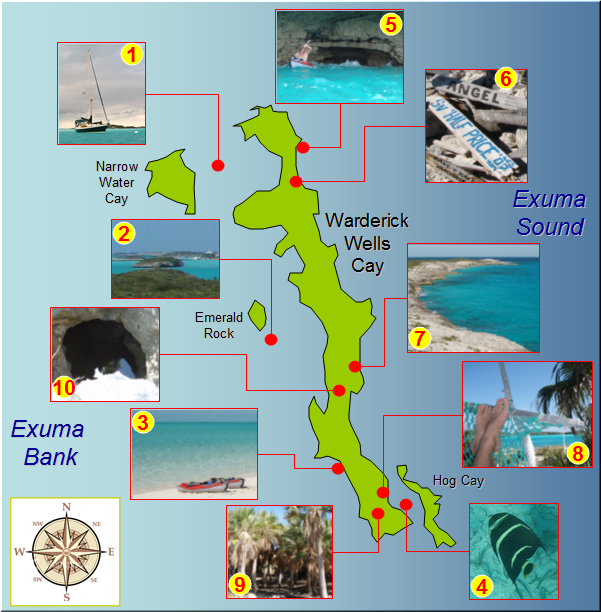
For the two days described below, I have created the following map, of sorts. The red numbers on each thumbnail photo are referred to in the text below with bold numbering. Hopefully, this will give you a sense for our experiences exploring the Exuma Cays Land & Sea Park. Just to give you an idea of the scale of our explorations, Warderick Wells Cay is 2.5 nautical miles long from its northern to its southern tip.
[Note: full resolution photos for each thumbnail shown below, and many, many more have been added to our 'Exumas, Bahamas' link on the left]
On Friday morning, we awoke with a mixture of conflicting motivators. On one hand, we were running on minimal sleep for the week. But on the other hand, there was this big, beautiful park to explore, and the weather was ideal. As you may have guessed, knowing us, exploration won out over the need for rest.
We set our sights on doing some snorkeling in this crystal clear water. We departed the big boat (1) and kayaked our way against tidal current and wind to a point just off of Emerald Rock (2). There are several coral heads here and dinghy moorings to which we could tie the kayaks. Unfortunately, just as we had tied off to a mooring, here comes a dinghy, no...wait..., two dinghies, no...make that four dinghies, motoring out and tying off to a mooring right next to us. Sheryl and I both agreed that snorkeling is best when you've got the place all to yourself, so we untied and paddled on.
Still working against a considerable wind and chop, our lack of sleep and general fatigue began to come to light. We turned the kayaks in to land at Loyalist Beach (3), and walked them for a while to rest our arms and shoulders. In a tired voice, Sheryl observed, "We always seem to be going against the wind or against the current or both. Do the Mayles always have to do things the hard way?"
Once we got down toward the south end of the island, we climbed back into the kayaks and battled the tide, again, going around the southeastern tip of the island. Once we were around the corner and nestled between Hog Cay and the main island (4), we were rewarded for all of our efforts.
The setting was absolutely pristine. The main island blocked the chop of the SW wind and the little island blocked the ocean swell on the Exuma Sound. The alternating deep and shoal water between the two land masses showed off the blue-to-white color gradient under a cloudless midday sun. Best of all, we had it all to ourselves.
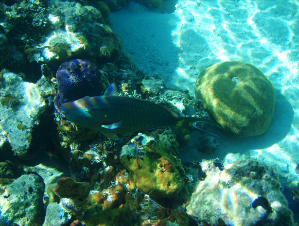
Energized by this little piece of paradise, we parked the dinghies on the beach and grabbed our snorkel gear. Although we had to work against a bit of tidal current to view the coral formations, it was definitely worth the effort. The protected nature of the park created an opportunity to see more colorful fish and fragile coral than either of us had seen anywhere before. Of course, it helps that the water is gin-clear and that we had uninterrupted direct solar lighting. Sheryl used a considerable amount of battery power on her digital camera in the underwater portion of our journey, and the results were phenomenal.
Eventually, our fin-enabled lower body workout took its toll, and we decided to go back to our focus on the upper body. It was time to point the kayaks back to the big boat. Here we had two options, go back the way we came or push on around the sound side of the island. With conditions on the Exuma Sound being reasonably benign, we decided to take the 'blue water' route and perform a circumnavigation of Warderick Wells Cay.
The west side of the island has fewer beaches and more rock formations. From our vantage point, we were able to view a few caves and even go in for some close-up exploration (5), being careful not to let the breaking waves push us into the rocks. We made it around the northwestern tip of island without experiencing any squalls or being blown out to sea, and thought we would have an easy ride, with the incoming tidal current, back to Prudence. Unfortunately, the SW winds had strengthened and moved even a little more west. Wind trumps tide in this circumstance, and we had to battle with every last stroke of the paddles until we grabbed the toerail of the big boat. Whew, we finally made it back. Yes, it appears that the Mayles do have to do everything the hard way. Needless to say, sleep came easily to us both on Friday night.
With a good night's sleep under our collective belt, team Prudence decided to strike out on foot for Saturday's exploration. Marked trails cover the island, and we were anxious to see things from a different perspective. We kayaked to the closest beach, and let our feet carry us from there.
The first place we explored was the famous Boo Boo Hill (6). Of course, it is really only famous in cruising circles. This 'landmark' is a spot where passing cruisers will leave a sign with their boat name, in a manner of saying, "We were here." Sheryl and I had not brought a sign with us to add to the collection; however, we did get a great photo of the sign collection with the mooring field in the background.
From Boo Boo Hill, we walked a trail along the rocky west side of the island (7), gaining a different perspective of the trip we had made by kayak only yesterday. By midday, we found ourselves, once again, in the idyllic spot where Hog Cay parallels the main island. This time we strolled along a pristine beach and admired the colors of the water from a makeshift hammock (8), which someone had constructed of drift net and line which had washed ashore. I could have stayed there all day.
But, again, with the return trip ahead of us, we kept our respite brief and were back on the trails toward the east side of the island (9). The trails here took on a unique character. We traveled inland through rocks and trees, occasionally emerging out onto a beautiful beach. We would walk the beach, then head up another trail through rocks and trees, only to repeat the whole procedure every 10-20 minutes.
The beaches were beautiful, but slogging through sand wearing shoes is not the way I like to walk the beach. And the shoes were required each time we returned to the jagged rocks. In addition, the rocks were loose and each inland trek was up to the top of a hill and then back down. This had the advantage of offering us numerous opportunities to appreciate the vista, and we always knew where we were. However, it also resulted in a very tiring hike. By early afternoon, we were not as steady on our feet as we needed to be. This was important because every so often the rock would open up into a very big, very deep hole (10). One misstep could mean that one of us would be hiking back to get a long rope.
Fortunately, no missteps came to pass, and we made it back to the kayaks with plenty of daylight to burn. There was a Saturday night social here we were anxious to attend. We have not done any real socializing with other cruisers since Hope Town, and it was nice to meet at the beach tonight with other cruisers here in the mooring field. A few snacks, a few drinks, and good conversation rounded out our day very nicely. Most are staying here for Christmas, but plans for Prudence are still uncertain. If the weather forecast holds for Monday, we may be moving on. Only time will tell, dear Reader, only time will tell.
24 23.711' N, 076 38.141' W (CLICK HERE for Google Maps)
In addition to the natural splendor which I will try to relate below, the Exuma Cays Land & Sea Park, here on Warderick Wells Cay, also offers internet access ($10/day). Since we can see the WiFi signal with our internal laptop card (read: no booster required), we signed up for 24-hours of internet the moment we arrived here. Consequently, Sheryl and I had a late night uploading pictures, updating the blog site, and responding to e-mail. Another late night among many this week.
For the two days described below, I have created the following map, of sorts. The red numbers on each thumbnail photo are referred to in the text below with bold numbering. Hopefully, this will give you a sense for our experiences exploring the Exuma Cays Land & Sea Park. Just to give you an idea of the scale of our explorations, Warderick Wells Cay is 2.5 nautical miles long from its northern to its southern tip.
[Note: full resolution photos for each thumbnail shown below, and many, many more have been added to our 'Exumas, Bahamas' link on the left]
On Friday morning, we awoke with a mixture of conflicting motivators. On one hand, we were running on minimal sleep for the week. But on the other hand, there was this big, beautiful park to explore, and the weather was ideal. As you may have guessed, knowing us, exploration won out over the need for rest.
We set our sights on doing some snorkeling in this crystal clear water. We departed the big boat (1) and kayaked our way against tidal current and wind to a point just off of Emerald Rock (2). There are several coral heads here and dinghy moorings to which we could tie the kayaks. Unfortunately, just as we had tied off to a mooring, here comes a dinghy, no...wait..., two dinghies, no...make that four dinghies, motoring out and tying off to a mooring right next to us. Sheryl and I both agreed that snorkeling is best when you've got the place all to yourself, so we untied and paddled on.
Still working against a considerable wind and chop, our lack of sleep and general fatigue began to come to light. We turned the kayaks in to land at Loyalist Beach (3), and walked them for a while to rest our arms and shoulders. In a tired voice, Sheryl observed, "We always seem to be going against the wind or against the current or both. Do the Mayles always have to do things the hard way?"
Once we got down toward the south end of the island, we climbed back into the kayaks and battled the tide, again, going around the southeastern tip of the island. Once we were around the corner and nestled between Hog Cay and the main island (4), we were rewarded for all of our efforts.
The setting was absolutely pristine. The main island blocked the chop of the SW wind and the little island blocked the ocean swell on the Exuma Sound. The alternating deep and shoal water between the two land masses showed off the blue-to-white color gradient under a cloudless midday sun. Best of all, we had it all to ourselves.
Energized by this little piece of paradise, we parked the dinghies on the beach and grabbed our snorkel gear. Although we had to work against a bit of tidal current to view the coral formations, it was definitely worth the effort. The protected nature of the park created an opportunity to see more colorful fish and fragile coral than either of us had seen anywhere before. Of course, it helps that the water is gin-clear and that we had uninterrupted direct solar lighting. Sheryl used a considerable amount of battery power on her digital camera in the underwater portion of our journey, and the results were phenomenal.
Eventually, our fin-enabled lower body workout took its toll, and we decided to go back to our focus on the upper body. It was time to point the kayaks back to the big boat. Here we had two options, go back the way we came or push on around the sound side of the island. With conditions on the Exuma Sound being reasonably benign, we decided to take the 'blue water' route and perform a circumnavigation of Warderick Wells Cay.
The west side of the island has fewer beaches and more rock formations. From our vantage point, we were able to view a few caves and even go in for some close-up exploration (5), being careful not to let the breaking waves push us into the rocks. We made it around the northwestern tip of island without experiencing any squalls or being blown out to sea, and thought we would have an easy ride, with the incoming tidal current, back to Prudence. Unfortunately, the SW winds had strengthened and moved even a little more west. Wind trumps tide in this circumstance, and we had to battle with every last stroke of the paddles until we grabbed the toerail of the big boat. Whew, we finally made it back. Yes, it appears that the Mayles do have to do everything the hard way. Needless to say, sleep came easily to us both on Friday night.
With a good night's sleep under our collective belt, team Prudence decided to strike out on foot for Saturday's exploration. Marked trails cover the island, and we were anxious to see things from a different perspective. We kayaked to the closest beach, and let our feet carry us from there.
The first place we explored was the famous Boo Boo Hill (6). Of course, it is really only famous in cruising circles. This 'landmark' is a spot where passing cruisers will leave a sign with their boat name, in a manner of saying, "We were here." Sheryl and I had not brought a sign with us to add to the collection; however, we did get a great photo of the sign collection with the mooring field in the background.
From Boo Boo Hill, we walked a trail along the rocky west side of the island (7), gaining a different perspective of the trip we had made by kayak only yesterday. By midday, we found ourselves, once again, in the idyllic spot where Hog Cay parallels the main island. This time we strolled along a pristine beach and admired the colors of the water from a makeshift hammock (8), which someone had constructed of drift net and line which had washed ashore. I could have stayed there all day.
But, again, with the return trip ahead of us, we kept our respite brief and were back on the trails toward the east side of the island (9). The trails here took on a unique character. We traveled inland through rocks and trees, occasionally emerging out onto a beautiful beach. We would walk the beach, then head up another trail through rocks and trees, only to repeat the whole procedure every 10-20 minutes.
The beaches were beautiful, but slogging through sand wearing shoes is not the way I like to walk the beach. And the shoes were required each time we returned to the jagged rocks. In addition, the rocks were loose and each inland trek was up to the top of a hill and then back down. This had the advantage of offering us numerous opportunities to appreciate the vista, and we always knew where we were. However, it also resulted in a very tiring hike. By early afternoon, we were not as steady on our feet as we needed to be. This was important because every so often the rock would open up into a very big, very deep hole (10). One misstep could mean that one of us would be hiking back to get a long rope.
Fortunately, no missteps came to pass, and we made it back to the kayaks with plenty of daylight to burn. There was a Saturday night social here we were anxious to attend. We have not done any real socializing with other cruisers since Hope Town, and it was nice to meet at the beach tonight with other cruisers here in the mooring field. A few snacks, a few drinks, and good conversation rounded out our day very nicely. Most are staying here for Christmas, but plans for Prudence are still uncertain. If the weather forecast holds for Monday, we may be moving on. Only time will tell, dear Reader, only time will tell.
| Vessel Name: | Prudence |
| About: |
Gallery not available
- PHOTOS:
- Dec 16, 2008 - May 21, 2009
- Mar 17, 2008 - Dec 15, 2008
- Nov 01, 2007 - Mar 16, 2008
- Our SC35 Sailboat: PRUDENCE
- SELECTED BLOGS
- Jan'05: The Idea
- May'05: First Cruise - Belize
- Aug'05: Buying Ashiya
- Oct'05: School in St. Vincent
- Nov'05: Ocracoke on Ashiya
- Jul'06: Long Trip on Ashiya
- Oct'06: Prudence Comes Home
- Nov'07: First Night Offshore
- Nov'07: Offshore Take Two
- Nov'07: Gulf Stream Crossing
- Dec'07: Green Turtle Cay
- Dec'07: Lynyard Cay
- Dec'07: Warderick Wells Cay
- Jan'08: George Town
- Jan'08: Life without a Fridge
- Jan'08: Mayaguana Island
- Jan'08: Turks & Caicos
- Jan'08: Dominican Republic
- Jan'08: Down the Waterfalls
- Feb'08: Puerto Rico
- Feb'08: Starter Troubles
- Feb'08: Vieques
- Mar'08: Finally Sailing Again
- Mar'08: Trip So Far
- Mar'08: Hiking Culebra
- Mar'08: Kayak & Snorkel I
- Mar'08: Teak and Waterspouts
- Mar'08: Kayak & Snorkel II
- Mar'08: Bottom Cleaning
- Apr'08: Culebra Social Life
- Apr'08: Culebra Routine
- Apr'08: Culebra Beaches
- Apr'08: Culebrita
- Jun'08: Kayak & Snorkel III
- Jun'08: Kayak & Snorkel IV
- Jun'08: Manta Ray
- Jun'08: Sea Turtles
- Jul'08: Cost of Cruising
- Jul'08: Busy Week in Culebra
- Jul'08: Getting to Land
- Jul'08: Leatherback Boil
- Jul'08: Fish and Volcano Dust
- Aug'08: Teaching Algebra
- Sep'08: Culebra Card Club
- Oct'08: Kayak & Snorkel V
- Oct'08: Prep for Hurricane
- Oct'08: Hurricane Omar
- Oct'08: Fish and Sea Glass
- Oct'08: Waterspouts
- Dec'08: Hurricane Season Ends
- Dec'08: Culebra to St. Martin
- Jan'09: Antigua Part 1
- Feb'09: The Saints
- Feb'09: Visiting Dominica
- Mar'09: Antigua Part 2
- Apr'09: Antigua to Bermuda
- May'09: Bermuda to Norfolk
- FULL LIST of Blog Entries
SailBlogs Friends