

- PHOTOS:
- Dec 16, 2008 - May 21, 2009
- Mar 17, 2008 - Dec 15, 2008
- Nov 01, 2007 - Mar 16, 2008
- Our SC35 Sailboat: PRUDENCE
- SELECTED BLOGS
- Jan'05: The Idea
- May'05: First Cruise - Belize
- Aug'05: Buying Ashiya
- Oct'05: School in St. Vincent
- Nov'05: Ocracoke on Ashiya
- Jul'06: Long Trip on Ashiya
- Oct'06: Prudence Comes Home
- Nov'07: First Night Offshore
- Nov'07: Offshore Take Two
- Nov'07: Gulf Stream Crossing
- Dec'07: Green Turtle Cay
- Dec'07: Lynyard Cay
- Dec'07: Warderick Wells Cay
- Jan'08: George Town
- Jan'08: Life without a Fridge
- Jan'08: Mayaguana Island
- Jan'08: Turks & Caicos
- Jan'08: Dominican Republic
- Jan'08: Down the Waterfalls
- Feb'08: Puerto Rico
- Feb'08: Starter Troubles
- Feb'08: Vieques
- Mar'08: Finally Sailing Again
- Mar'08: Trip So Far
- Mar'08: Hiking Culebra
- Mar'08: Kayak & Snorkel I
- Mar'08: Teak and Waterspouts
- Mar'08: Kayak & Snorkel II
- Mar'08: Bottom Cleaning
- Apr'08: Culebra Social Life
- Apr'08: Culebra Routine
- Apr'08: Culebra Beaches
- Apr'08: Culebrita
- Jun'08: Kayak & Snorkel III
- Jun'08: Kayak & Snorkel IV
- Jun'08: Manta Ray
- Jun'08: Sea Turtles
- Jul'08: Cost of Cruising
- Jul'08: Busy Week in Culebra
- Jul'08: Getting to Land
- Jul'08: Leatherback Boil
- Jul'08: Fish and Volcano Dust
- Aug'08: Teaching Algebra
- Sep'08: Culebra Card Club
- Oct'08: Kayak & Snorkel V
- Oct'08: Prep for Hurricane
- Oct'08: Hurricane Omar
- Oct'08: Fish and Sea Glass
- Oct'08: Waterspouts
- Dec'08: Hurricane Season Ends
- Dec'08: Culebra to St. Martin
- Jan'09: Antigua Part 1
- Feb'09: The Saints
- Feb'09: Visiting Dominica
- Mar'09: Antigua Part 2
- Apr'09: Antigua to Bermuda
- May'09: Bermuda to Norfolk
- FULL LIST of Blog Entries
SailBlogs Friends


15 July 2009
14 July 2009
15 June 2009
14 June 2009 | Annapolis, MD
13 June 2009
12 June 2009
11 June 2009
10 June 2009 | Little Creek Marina, Norfolk, VA, USA
04 June 2009 | Little Creek Marina, Norfolk, VA, USA
31 May 2009 | Little Creek Marina, Norfolk, VA, USA
29 May 2009 | Little Creek Marina, Norfolk, VA, USA
26 May 2009 | Little Creek Marina, Norfolk, VA, USA
25 May 2009 | Little Creek Marina, Norfolk, VA, USA
13 May 2009 | through 21-May-2009
13 May 2009 | through 21-May-2009
12 May 2009 | St George's Town, Bermuda
11 May 2009 | St George's Town, Bermuda
07 May 2009 | St George's Town, Bermuda
04 May 2009 | St George's Town, Bermuda
21 April 2009 | through 02-May-2009
Nobody Knows Where We Are (until, of course, we post this blog)
27 February 2008 | Salinas to Puerto Patillas, Puerto Rico
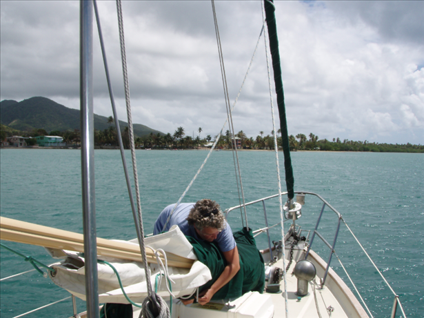
CURRENT LOCATION: Anchored off Puerto Patillas, Puerto Rico
17 58.524' N, 065 59.617' W
It is an interesting sensation when you sit back at the end of a long day and realize that nobody in the world knows where you are (save, of course, for my lovely wife). How did we get to this solitary anchorage, where nary another boat has floated by, much less anchored with us? Well...
The alarm went off at 5AM, and we were underway by 6AM. We motored across smooth water in the pre-dawn light as we approached Boca de Infierno. This cut through some barrier islands off of Bahia de Jobos looked relatively straightforward on the chart; however, we were warned by our guidebook to approach this departure at first light (a rare suggestion from Mr. Van Sant, the king of the night lee). It was a good thing, because other than the bearings on land, the only visual of the very shallow reefs one must pass through when transiting this cut are the waves crashing on said reefs.
Once we cleared Boca de Infierno, we looked back and began to think about what 'boca de infierno' means. Later, our Spanish-English dictionary related that we had just passed through the 'mouth of hell.' I, for one, am glad we didn't look these words up beforehand.
Out on the open Caribbean Sea, the winds and waves built quickly, and our speed over the water dropped dramatically. It is amazing how we have grown accustomed to such high winds. With gusts up to 30 and 25 knots sustained, when it did drop down to 20 knots it seemed like a gentle breeze. From nearly 5 knots motoring across the calmer waters in the early morning our average hourly velocity dropped to about 3 knots. The waves ranged from large to confused, making it necessary for us to hand steer the entire way. Fortunately, we had planned a short trip, and (tacking included) we covered a distance of 22 nautical miles by noon.
With the anchor set, we spent some time researching the next phase of the trip. With new waypoints entered into the GPS, we had the remainder of the afternoon to read and relax. Dinner was served early in anticipation of an early night to bed (which for us means sleepy-time shortly after sunset). Tomorrow is bound to be another busy day.
| Vessel Name: | Prudence |
| About: |
Gallery not available
- PHOTOS:
- Dec 16, 2008 - May 21, 2009
- Mar 17, 2008 - Dec 15, 2008
- Nov 01, 2007 - Mar 16, 2008
- Our SC35 Sailboat: PRUDENCE
- SELECTED BLOGS
- Jan'05: The Idea
- May'05: First Cruise - Belize
- Aug'05: Buying Ashiya
- Oct'05: School in St. Vincent
- Nov'05: Ocracoke on Ashiya
- Jul'06: Long Trip on Ashiya
- Oct'06: Prudence Comes Home
- Nov'07: First Night Offshore
- Nov'07: Offshore Take Two
- Nov'07: Gulf Stream Crossing
- Dec'07: Green Turtle Cay
- Dec'07: Lynyard Cay
- Dec'07: Warderick Wells Cay
- Jan'08: George Town
- Jan'08: Life without a Fridge
- Jan'08: Mayaguana Island
- Jan'08: Turks & Caicos
- Jan'08: Dominican Republic
- Jan'08: Down the Waterfalls
- Feb'08: Puerto Rico
- Feb'08: Starter Troubles
- Feb'08: Vieques
- Mar'08: Finally Sailing Again
- Mar'08: Trip So Far
- Mar'08: Hiking Culebra
- Mar'08: Kayak & Snorkel I
- Mar'08: Teak and Waterspouts
- Mar'08: Kayak & Snorkel II
- Mar'08: Bottom Cleaning
- Apr'08: Culebra Social Life
- Apr'08: Culebra Routine
- Apr'08: Culebra Beaches
- Apr'08: Culebrita
- Jun'08: Kayak & Snorkel III
- Jun'08: Kayak & Snorkel IV
- Jun'08: Manta Ray
- Jun'08: Sea Turtles
- Jul'08: Cost of Cruising
- Jul'08: Busy Week in Culebra
- Jul'08: Getting to Land
- Jul'08: Leatherback Boil
- Jul'08: Fish and Volcano Dust
- Aug'08: Teaching Algebra
- Sep'08: Culebra Card Club
- Oct'08: Kayak & Snorkel V
- Oct'08: Prep for Hurricane
- Oct'08: Hurricane Omar
- Oct'08: Fish and Sea Glass
- Oct'08: Waterspouts
- Dec'08: Hurricane Season Ends
- Dec'08: Culebra to St. Martin
- Jan'09: Antigua Part 1
- Feb'09: The Saints
- Feb'09: Visiting Dominica
- Mar'09: Antigua Part 2
- Apr'09: Antigua to Bermuda
- May'09: Bermuda to Norfolk
- FULL LIST of Blog Entries
SailBlogs Friends