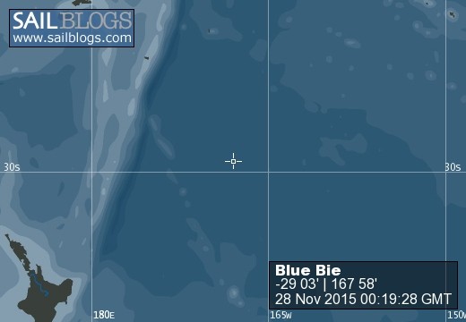
Blue Bie
Blue Bie
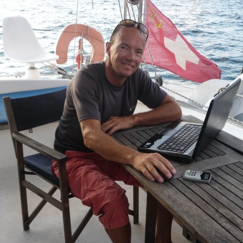
Who: Philip Duss
Port: Basel, Switzerland
Favorites
27 November 2015 | Norfolk Island
21 May 2015 | Nananu-I-Ra
01 February 2015 | Majuro, Marshall Islands
25 May 2014 | Bikini Atoll
30 April 2014 | Rongerik, Marshall Islands
21 April 2014 | Majuro, Marshall Islands
07 April 2014 | Majuro, Marshall Islands
20 March 2014 | Maloelap, Marshall Islands
24 February 2014 | Utirik, Marshall Islands
30 January 2014 | Majuro, Marshall Islands
24 January 2014 | Majuro, Marshall Islands
31 December 2013 | Majuro, Marshall Islands
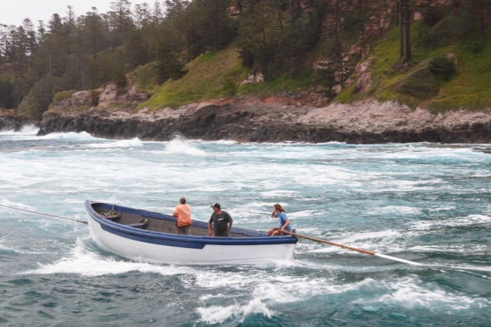
Norfolk Island
27 November 2015 | Norfolk Island
Philip
NAUTICAL (for those interested ...)
Norfolk Island is very small, some 3 by 2 nautical miles. There is no protected all-weather anchorage, but there's enough anchorages spread around the island to find protection, some of them without dinghy-landing though. The two main anchorages and piers are Kingston Bay in the south and Cascade Bay in the north. The local lift out their small power boats with the permanent cranes; hoisting them by hitching the cable to the truck and reversing away. At low tide (and ideal conditions) both piers are calm enough to leave the dinghy. In calm weather, one can also pull the dinghy up the ramp at Kingston Bay. But certainly one has to pay attention to the weather and accept that one might not be able to go on land every day.
Custom and Immigration have been very nice and are standing by on VHF 28. Norfolk is an Australian territory, but is likely to be fully integrated next summer. I got a free online Australian visa, but Immigration said that I wouldn't have needed one as crew. Other than the visa there are no Immigration or Customs charges. This might change next year. They didn't come on board for clearance. They provided the exit clearance (with a date of our choosing) on checking in, allowing immediate departure in bad weather. Norfolk Telecom has WiFi Hotspots on the Island. At AUD 25 per GB not cheap, but conveniently providing internet on board with hotspots at Kingston and Cascade Bay.
BRIEF HISTORY
Norfolk Island has first been by the Polynesians from 900-1500 AD, then twice as penal colony (1788-1814, 1825-1855) and finally by the mutineers of the Bounty. The latter settled first in Pitcairn, but moved to Norfolk Island in 1856 when Pitcairn got too small, with a few families moving back to Pitcairn to establish the current settlement there within a year.
Today, Norfolk Island has some 2000 inhabitants, half of whom are descendants of the Bounty mutineers, a lovely little town (Burnt Pine) and receives some 500 mostly elderly tourists a week. The stunning Norfolk Pine is endemic to Norfolk Island and well known all over the world as Christmas tree. It's as ubiquitous as the free-ranging cows and chicken; only the town is protected with cow grids and fences. The climate is subtropical and I managed not to wear long trousers while there:) Town is on a 100mhigh plateau and a half hour walk from the main anchorages, but you'd be hard pressed to ignore all the invitations for a ride. It is a small and very welcoming community!
ATTRACTIONS
Nature is beautiful with many seabirds nesting in the cliffs (tropic birds, boobies, terns, shearwater), the Norfolk Pine and the fee ranging animals. While not much remains of the Polynesian settlement and first penal colony, the buildings of the second penal settlement are well preserved and made into an attractive world heritage site and museum. Town is nice, with plenty cafés, galleries and boutiques, well stocked with imported products and excellent local beef, fruits and vegetables, but not cheap.
I had a lovely week on Norfolk Island. It's an enchanted and very interesting place and protected enough to wait out incline weather on the way to/from New Zealand. Of course, there's always more to be seen, but a week seemed plenty to take in all.
Whale encounter
21 May 2015 | Nananu-I-Ra
Philip
The Marshall Islands are a rather unique cruising ground. While the capital Majuro isn't too amazing, the outer islands are absolutely fantastic. Where else can you sail, swim, dive & kite uninhabited atolls in the world with no human presence within 60 miles, with birds and fishes who aren’t used to human presence? Don't be deterred to sail there by the majority of cruisers who claim to have been there, but never ventured out of Majuro...
After three cyclone seasons in the Marshall Islands it's time to move on or better return to Fiji, which I enjoy as much as the Marshall Islands. More developed, but also more varied with more fresh food available. As beautiful as the Marshall Islands are, nothing grows on these coral atolls. You’ll have to revise the idea of tropical fruits dropping in your mouth.
The weather is pretty untypical this year. The water temperature is higher than normal, on the brink of El Niño, resulting in much weaker trade winds than other years. Bruce and Laura on Pacific Hwy are leaving on the same day as me and we’re keeping in email and SSB contact with half a dozen other yachts leaving within the next few days. I’m leaving in light westerlies, so light that I motor downwind to the Eastern end of the island before unrolling my new Code 0, which propelled me nicely in the light winds. Pretty soon the winds turned southeast and I’m sailing hard on the wind, which is very comfortable in these light winds.
I could write 20 paragraphs on all the wind directions I’ve had, suffice to say that I the winds are coming from all usual and unusual directions, allowing me at times to sail where I want and pushing or sucking me off course at other times. I’m having it all, but hardly ever above 15 knots and I’m sailing for the most part without a reef in the sails, rather unusual for light weight Blue Bie. After a few days squalls are starting to crop up, but even they are bringing less than 20 knots. I can hunt them for beautiful downwind rides under Code 0 during the day. During the night however, when I don’t see them coming, they have me walloping on the windward side.
While the light wind are making for very comfortable sailing, they’re not letting me have much rest during the night, because they tend to be fickle and ever changing. I didn’t see much traffic, but had wonderful starry nights when the full moon wasn’t illuminating the firmament. Slowly but surely the Southern Cross came into view and crept higher and higher over the horizon with every day I sailed further south. Easy to see how the old navigators could determine the latitude, but were struggling to determine the longitude.
After a week the days are starting to flow into each other, the beginning is too far away to remember, the destination too far away to think about and days and nights too contour less to keep them apart. The daily rhythm is given by weather, emailing and weather analysis in the morning, small errands in the morning, reading time in the afternoon, a 4 o’clock dinner and early evening SSB net. Communication has much improved thanks to the new Iridium Go satellite hotspot and the PredictWind weather routing. I’m not getting four different weather forecasts and routing recommendations. While you might think that four forecasts must be confusing, it’s actually the opposite: If all four agree you can have high confidence that they’re correct, if you have four different forecast, you know not to put too much weight on any of them – and I had lots of this during this passage. I can only recommend PredictWind!
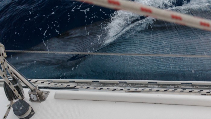
On this background one of the most memorable experience of my life happened. While reading lazily the biography of Ferdinand Magellan, I feel a slight rocking motion. Not bothering too much, I rush to the cockpit when it repeats shortly afterward and see a fin sticking above the deck to the height of the lifelines. Not thinking too much, I'm heading over and see a whale swimming alongside Blue Bie, rubbing its belly against the hull and looking into my eye!
I'm freaking out and have no idea what to do. What can I do? Nothing! If it wants to ram Blue Bie I can do absolutely nothing!
The only idea I have is to get the camera and to take Blue Bie off the autopilot trying to avoid the whale. But that's kind of useless, because a few more times the whale is breathing at a distance, dives and comes up from behind, diving underneath the rudder, coming alongside and scratching its belly against Blue Bie.
My nerves are completely frayed. But there's never a heavy impact nor any air of violence. By the third time I’m starting to believe that the whale means no harm, to feel elated having such an extraordinary experience and to talk to the whale. It’s not talking back though, but it does have a very foul smelling breath! Reviewing the pictures, it has probably been a roughly 8m long Minke Whale weighing as much as Blue Bie. Interesting that Wayne and Christine on Learnativity see a pod of whales a few days later only a few miles from that position.
This encounter has shaken me to the core, I’m feeling totally vulnerable and it’s taking me two days to calm down. But the days start flowing into each other again, I’m crossing the equator the seventh time and after ten days I’m approaching Funafuti, a convenient stop-over. However, I feel so much in the groove that I prefer to continue towards Fiji without stopping. The wind continues to be light and from a favorable direction until the last day, when the SE trades kicked in and I had to tack 3 hours against 18 knots of wind before making it into the lee of the Lau Group and in the Rabi Channel. Tavueni is greeting me with wafts of verdant air and the song of birds and a few hours later I’m sailing into Savu Savu where I’m clearing in after 16 days at sea. Slow but very comfortable 1’600 miles. I could have shortened the passage time by motoring, but never felt like it.
Fiji is a big change to the Marshall Islands, lush with plenty of fresh fruits, friendly people and fast internet There’s a lot to be said for being able to wander between worlds. I meeting old and new friends in Savu Savu, but soon feel like heading over to Nananu-I-Ra for a few weeks of kite surfing, finally testing my new kite. More of that in my next blog.
After three cyclone seasons in the Marshall Islands it's time to move on or better return to Fiji, which I enjoy as much as the Marshall Islands. More developed, but also more varied with more fresh food available. As beautiful as the Marshall Islands are, nothing grows on these coral atolls. You’ll have to revise the idea of tropical fruits dropping in your mouth.
The weather is pretty untypical this year. The water temperature is higher than normal, on the brink of El Niño, resulting in much weaker trade winds than other years. Bruce and Laura on Pacific Hwy are leaving on the same day as me and we’re keeping in email and SSB contact with half a dozen other yachts leaving within the next few days. I’m leaving in light westerlies, so light that I motor downwind to the Eastern end of the island before unrolling my new Code 0, which propelled me nicely in the light winds. Pretty soon the winds turned southeast and I’m sailing hard on the wind, which is very comfortable in these light winds.
I could write 20 paragraphs on all the wind directions I’ve had, suffice to say that I the winds are coming from all usual and unusual directions, allowing me at times to sail where I want and pushing or sucking me off course at other times. I’m having it all, but hardly ever above 15 knots and I’m sailing for the most part without a reef in the sails, rather unusual for light weight Blue Bie. After a few days squalls are starting to crop up, but even they are bringing less than 20 knots. I can hunt them for beautiful downwind rides under Code 0 during the day. During the night however, when I don’t see them coming, they have me walloping on the windward side.
While the light wind are making for very comfortable sailing, they’re not letting me have much rest during the night, because they tend to be fickle and ever changing. I didn’t see much traffic, but had wonderful starry nights when the full moon wasn’t illuminating the firmament. Slowly but surely the Southern Cross came into view and crept higher and higher over the horizon with every day I sailed further south. Easy to see how the old navigators could determine the latitude, but were struggling to determine the longitude.
After a week the days are starting to flow into each other, the beginning is too far away to remember, the destination too far away to think about and days and nights too contour less to keep them apart. The daily rhythm is given by weather, emailing and weather analysis in the morning, small errands in the morning, reading time in the afternoon, a 4 o’clock dinner and early evening SSB net. Communication has much improved thanks to the new Iridium Go satellite hotspot and the PredictWind weather routing. I’m not getting four different weather forecasts and routing recommendations. While you might think that four forecasts must be confusing, it’s actually the opposite: If all four agree you can have high confidence that they’re correct, if you have four different forecast, you know not to put too much weight on any of them – and I had lots of this during this passage. I can only recommend PredictWind!
On this background one of the most memorable experience of my life happened. While reading lazily the biography of Ferdinand Magellan, I feel a slight rocking motion. Not bothering too much, I rush to the cockpit when it repeats shortly afterward and see a fin sticking above the deck to the height of the lifelines. Not thinking too much, I'm heading over and see a whale swimming alongside Blue Bie, rubbing its belly against the hull and looking into my eye!
I'm freaking out and have no idea what to do. What can I do? Nothing! If it wants to ram Blue Bie I can do absolutely nothing!
The only idea I have is to get the camera and to take Blue Bie off the autopilot trying to avoid the whale. But that's kind of useless, because a few more times the whale is breathing at a distance, dives and comes up from behind, diving underneath the rudder, coming alongside and scratching its belly against Blue Bie.
My nerves are completely frayed. But there's never a heavy impact nor any air of violence. By the third time I’m starting to believe that the whale means no harm, to feel elated having such an extraordinary experience and to talk to the whale. It’s not talking back though, but it does have a very foul smelling breath! Reviewing the pictures, it has probably been a roughly 8m long Minke Whale weighing as much as Blue Bie. Interesting that Wayne and Christine on Learnativity see a pod of whales a few days later only a few miles from that position.
This encounter has shaken me to the core, I’m feeling totally vulnerable and it’s taking me two days to calm down. But the days start flowing into each other again, I’m crossing the equator the seventh time and after ten days I’m approaching Funafuti, a convenient stop-over. However, I feel so much in the groove that I prefer to continue towards Fiji without stopping. The wind continues to be light and from a favorable direction until the last day, when the SE trades kicked in and I had to tack 3 hours against 18 knots of wind before making it into the lee of the Lau Group and in the Rabi Channel. Tavueni is greeting me with wafts of verdant air and the song of birds and a few hours later I’m sailing into Savu Savu where I’m clearing in after 16 days at sea. Slow but very comfortable 1’600 miles. I could have shortened the passage time by motoring, but never felt like it.
Fiji is a big change to the Marshall Islands, lush with plenty of fresh fruits, friendly people and fast internet There’s a lot to be said for being able to wander between worlds. I meeting old and new friends in Savu Savu, but soon feel like heading over to Nananu-I-Ra for a few weeks of kite surfing, finally testing my new kite. More of that in my next blog.
Back home
01 February 2015 | Majuro, Marshall Islands
Philip
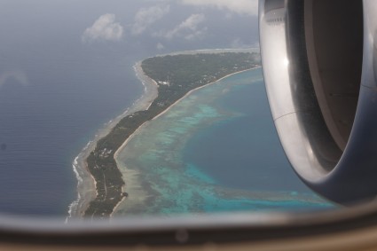
It feels good to see Majuro Atoll pass underneath the wings on the way home. I was mostly gone from Blue Bie for eight months and very much appreciate Teri's efforts to clean Blue Bie of all the mold which has collected in the meantime.
Arriving on board, I'm knackered by the heat, barely manage to finish a book in the shade. Day two sees my energy come back and I start unpacking all the goodies which we have sent ahead and get started to install the first ones.
We don't want to spend too much time in Majuro, longing to cruise and kite the outer Marshallese islands.
Sailing to the Rim of Bravo Crater
25 May 2014 | Bikini Atoll
teri

Bikini atoll is silent except for the lapping on inside of Blue Bies
hulls and the crashing of waves on the windward reefs. We've arrived at
the most famous of all the atolls, Bikini put Marshall Islands on the
global map, and unfortunately in the process it also removed the people
from their local map.
It's nearly June and the heat is humbling. 30-33 degrees Celsius with the
usual humidity in the 80 percent range; one of those really feels like hot
as hell kind of days....which has turned into weeks. A fine time and place
to be on anchor with the cool blue waters at your doorstep. We've been
cruising through the Ratik chain for the last 4 weeks, in the next hour we
will be at our final northern anchorage, Bravo Crater, and it looks like my
wish to kite ground zero will be fulfilled, the wind is 18-20 knots which
is perfect. We will be anchoring alongside Cherokee Rose and Mariposa,
Cafe Mariposa for those that are familiar with Michas 5 star cooking.
Besides the overshadowing of the historical events surrounding this leg of
our journey there is something extra special about being on deserted
islands, even if the desertion is due to conscienceless human induced
events. The ubiquitous paradox yet again
Strange to be in such a beautiful place and find yourself in the tidal
scrap pile for hours on end. The hunt for historical glass balls from the
Japanese fishing fleet is currently obsessing me. Buoys slippers, and
tons of plastic water bottles form a straight line along the high tide line
on most of the wind ward beaches. Refuse, Reuse, Recycle mantra came
decades to late, especially for the bird brains who mistake bottle caps for
food, dying in the process. Sometime in the not so distant future the
beaches will be multi colored as the plastic breaks down into granulated
pixels and mixes with the nature-made sand.
In preparation to enter the Bikini lagoon I just watched 'Radio Bikini,' a
well done documentary by Robert Stone, nominated for an Academy award in
1988 for best documentary feature. There are no actors re making the past,
Robert Stone has taken the past and brought it forward, splicing and
editing the footage into an easily digestible and emotionally charged film
summarizing the essence of all the facts besieging the atom bomb testing.
Human error, moral injustice and bureaucracy amongst others. Goggle Radio
Bikini to easily find the film, unless of course you are receiving this via
satellite email similar to the one I have just sent this from, then you may
be a bit more challenged.
After 5 days of experiencing more of the Bikini essence and having just
watched Radio Bikini for the second time the impressions have left a crater
in my mind similar to Bravo crater. The beautiful sights of my current
surroundings are in great contrast to the images from the documentary. 42K
men were here in this atoll occupying the sustainable amount of the local
Bikinins homeland. It's quite here now with only the three yachts in the
anchorage, we have just left the third island, Romuriko Island, a picture
perfect uninhabited island, with a huge cement bomb shelter on the
peninsula. We found 5 inch thick walls, multitudes of electric cables
going out to the lagoon, copper insulation and port holes looking out to
ground zero.
After visiting Rongerik atoll, the first island the Bikinins were
unsuccessfully relocated to in 1946, then Rongerlap where the American
dollar was hard at work on the backs of skeleton crews building a village
that resembled an American Suburb, which most of the Bikinis now refuse to
move to because of the still toxic levels of radiation, and now in Bikini
where we wander the beautiful beaches, snorkel the waters and land our
kites next to the Atom shelters, has left this whole World Heritage Atom
Bomb site in a more sullen place, somewhat like a hangover.
Penance is that what the Americans are trying to buy their way out of.
It's really a very big sad mess.
I don't have atomic eyes, I cannot see the fallout in the particles of the
sea or in the juice of the coconuts. I swim in the lagoon looking for two
headed fish, comb the beaches for past evidence while daring it to prove
itself as the mistake it was. The silence poison remains or so I've read,
the beauty stands still before my eyes inviting me in.
The Ghost Fleet is buried under 60 meters of water in the middle of the
lagoon, the 23 military ships including Nagota the flagship of the Imperial
Japanese Navy which ordered the command for Pearl Harbor to be blown up,
and just like here Honolulu too has its own Ghost Fleet, the US Arizona
sits still as the water buries the evidence of mankind’s insistence on war.
I am crossing my fingers that I will be able to scuba dive this World
Heritage Site (is Nagasaki and Hiroshima a WHS too) Most of the wrecks lie
in 50-60 meters of water, and this is the main reason why I want to dive
here, it's deep! I'm sure there will be some historical relevance decaying
at the bottom of the lagoon.
The resiliency of nature is insistent, this beautiful Bikini atoll stands
as evidence to that, but beautiful spaces are much easier to digest than
the half-life of radiation. Can we allow our senses to remain unscathed
focusing just on the beauty and leave the Ghosts of the past lie buried
just under the surface of the subconscious carrying the weight of knowing
on our collective minds Nature certainly cannot refuse the pasts mistakes
we've left on her doorstep. Is recycling and reusing the main ingredients
in resiliency. The fame of Bikini is in the eye of the beholder, the life
here shines with the paradox and I am once again grateful to be privy to
witness.
Kiting with boobies
30 April 2014 | Rongerik, Marshall Islands
Philip
Uninhabited islands come rarely even for us cruisers. Civilisation is spreading its wings further and further these days as we can see on the debris along the windward shores. There's literally not a meter without plastic, glass, fishing buoys, hard hats, flip flop and man made debris...
Rongerik atoll in the Western island chain is one of these jewels. A 10 mile long lagoon surrounded by a coral reef and dotted with only a few islands. Too little to support a community growing copra as was found out in 1946-48: The Americans relocated the Bikinians before the nuclear tests, but the community barely survived the two years of food shortage and malnutrition before they being evacuated to Kwajalein and later to Kili island. We have come well prepared with food lasting us for a month, but would run out of fresh food long before were Teri not sprouting fresh young green.
As spectacular as the anchorage and kite surfing are, the real stars here are the breeding sea birds. Hundreds of boobies, frigate birds and terns are breeding in the trees and on the ground. Without natural enemies they let us approach close and we have plenty of time to study them and their chicks. While kite surfing, we're often surrounded by a dozen of young boobies checking out this funny big bird in the sky close up. While hiking on the island, the boobies ride the winds approaching at times to arm's reach. The little terns flutter like dancers in the sky with the turquoise lagoon reflecting on their wings. Most of them are juvenile and not all have passed the flight exams yet, making us often laugh at their attemps.
The days are flowing in a natural rhythm, with slow espresso starts in the mornings, kite surfing during the day and photo excursions usually before sunset. - not to mention the cooking, cleaning, laundry and boat repairs:) We're quickly loosing count of days and very much enjoy to share these experiences with our friends Micha and Birgit on Mariposa.
Heading out
21 April 2014 | Majuro, Marshall Islands
teri--ITCZ plenty of rain
We are heading out after a quick fix (well kinda long) in Majuro, we've enjoyed wifi, eating out and the cruisers network of friends and fun. I picked up a Ukulele and hope to teach myself how to play. Thanks to Philip and his unstoppable technological support I could download YouTube videos to learn. Virtual uke friends will join our journey.
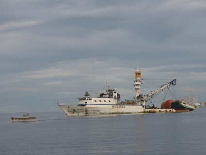
Our view of the Majuro tuna fishing fleet will be left in out wake.
I will post from the outer atolls and hope to entertain you'all with our adventures.
aloha nui
Our view of the Majuro tuna fishing fleet will be left in out wake.
I will post from the outer atolls and hope to entertain you'all with our adventures.
aloha nui
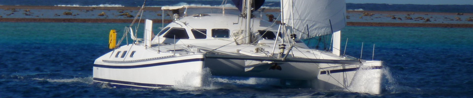
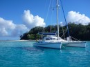
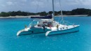
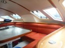
| Vessel Name: | Blue Bie |
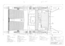
| Vessel Make/Model: | Outremer 43 |
| Hailing Port: | Basel, Switzerland |
| Crew: | Philip Duss |
| About: | Sailing around the world - getting slower as I'm going. Two years in the Atlantic, seven years in the South Pacific and counting:) Sailing, kite surfing, exploring and meeting people. Even with all the time in the world at my hands, I have more ideas than time |
Blue Bie's Photos - Blue Bie


Blue Bie
Who: Philip Duss
Port: Basel, Switzerland