
Magic's Adventure
21 April 2009 | Georgetown
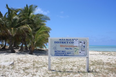
17 April 2009 | Mayaguana
11 November 2008 | St Croix
07 November 2008 | St Croix
22 October 2008 | St Croix
21 September 2008 | St Croix
15 September 2008 | Chaguaramas Bay, Trinidad
15 September 2008 | Chaguaramas Bay, Trinidad
14 September 2008 | Chaguaramas Bay, Trinidad
07 September 2008 | Scotland Bay, Trinidad
21 August 2008 | Clarkes Court Bay, Grenada
09 August 2008 | Clarkes Court Bay, Grenada
06 August 2008 | Clarkes Court Bay, Grenada
06 June 2008 | Bequia
05 June 2008 | Bequia
02 June 2008 | Bequia
28 May 2008 | Bequia
27 May 2008 | Bequia
26 May 2008 | Bequia
25 May 2008 | Guadaloupe
Mayaguana
21 April 2009 | Georgetown
Donna
We were definitely back in the Bahamas, anchored in water so clear that we felt as if Magic was sitting in a swimming pool. In 18ft of water, we could see the patterns on the starfish lying on the bottom beneath Magic's keel. We could even see each individual blade of sea grass. We had pulled into Abrahams Bay on the south side of Mayaguana. The bay is over 3 miles long by approximately 1½ miles wide and is entered through the reef at the west end. Manoeuvring through the reef makes the entrance tricky, but not too difficult and we negotiated our way in without a problem to anchor approximately ¼ mile inside the bay.
The settlement of Abrahams Bay is at the eastern end of the bay and we really needed to get there to be able to check in with customs and immigration. Although the whole bay is protected by the coral reef that surrounds it, the sheer size of it and the freshening wind meant that there was quite a fetch running so we didn't relish the idea of a 3 mile dinghy ride. We were also reluctant to take Magic further into the bay as we weren't confident of the depth of water closer to the settlement. In addition, the route was littered with scattered coral heads and we would have to navigate our way visually through these obstacles. After considering all of this, we decided to wait until the following day to see if conditions would settle down a little. However later that afternoon another yacht came into the bay, passed by us and continued towards the settlement. Dave gave them some time to reach their destination and then called them on the VHF to discuss the route down. They were able to confirm good depth of water all the way so we decided that we would also head down towards the settlement to be in a good position to go ashore the following morning.
We hauled anchor and I positioned myself on the bow to look out for any coral heads and guide Dave around them. With the light behind us the coral stood out like black shadows against an otherwise aquamarine landscape and it was easy to advise Dave to turn left or right to avoid any hazards. We slowly made our way down the bay, and from the bowsprit I was able to stare down and see the bottom in the crystal clear water. We passed a few fish, many starfish and a stingray that, even given the magnifying effects of the water, was the size of a coffee table. We took almost an hour to cover the 3 miles to the settlement, anchoring behind the reef in plenty of water and out of most of the fetch. We spent a very comfortable night and awoke refreshed the following morning ready to venture into Abrahams Bay.
The Abrahams Bay settlement is very similar to many others we have visited in The Bahamas. Alongside the Batelco (the local telephone company) tower stood a small building which housed the local Administrator who handled customs and immigration, acted as the local magistrate and managed local council affairs. This building was also the post office and housed the Mayaguana court. There was a small grocery store, a restaurant and bar and a schoolhouse and these together with a few homes made up the largest settlement on Mayaguana. The cruising guide for the area advised caution when approaching the dock by dinghy due to the very shallow water. Somehow we managed to time our excursion at low tide and our dinghy touched bottom on more than one occasion as we slowly glided up to the dock, throwing up clouds of sand and sending large schools of fry scuttling for cover. A local, 'Scully', greeted us at the dock perched on his bicycle and as he rode slowly up the track with us he explained where we had to go to check-in and gave us details of the local stores. In truth, we really did not need much direction as the administration building was obvious at the end of the main (and only) street, and the one store wasn't difficult to find either, but this is the sort of welcome we have come to expect on all the Bahamian islands and we spent a very pleasant few minutes with Scully as he proudly told us a little more about his island.
Mayaguana has approximately 350 residents and three main settlements, Abrahams Bay, the largest, Betsy Bay and Pirate's Well. It is one of the least populated of the inhabited Bahamian islands, although was once home to a US monitoring base for the Apollo space missions. Once the Apollo programme was discontinued, the 5,000 US personnel stationed here simply moved off the island, leaving all of the buildings and infrastructure they once occupied intact. The runway built for the programme stills exists and is now used by Bahamasair and private aircraft, but everything else has been left to ruin and has been mostly reclaimed by Mother Nature. There is some agriculture here and a hotel-come-guesthouse that caters to sports fishermen who come for the deep-sea and bone fishing. The locals also fish and collect conch, but apart from this there is little industry. Scully told us of plans to build a large resort here but again, as in much of the Bahamas, there is plenty of speculation and little in the way of actual development. And from a purely personal and selfish point of view we are pleased that this is the case. Although a resort would no doubt be good for the local economy, we love the sleepy and peaceful Bahamas of which Mayaguana is a perfect example and would hate to see it change.
As we noted earlier, once we had walked from the dock to the settlement it was easy to find the administration building. We completed the required paperwork, OK I completed the paperwork while Dave chatted to the ladies behind the desk, and were then told very politely that we would have a little bit of a wait as the Administrator was dealing with a case being heard in the court, that is, in the room right next to us. So we waited, chatting with the locals as they came to file an application for planning permission, collect a benefits payment or mail a letter. After about an hour our permits were ready, so we handed over our $300 fee and left. We took a stroll around the settlement (it didn't take very long!), picked up a few provisions and headed back to Magic. Fortunately the tide had come up a bit by this time and we were able get back without grounding the dinghy.
That afternoon we left the settlement and took Magic back to our original anchorage at the western end of the bay. The weather forecast was for light and variable wind the following day, but after that the wind was going to pick up to 20kts plus. We had heard from friends Tim & Linda that the snorkelling here was wonderful and we really wanted to get to the outside of the reef. The light winds would enable us to do just that, but we had to be in a position to snorkel early the next morning if we were to take advantage of the flat seas. The following morning there wasn't a breath of wind, the sea was totally flat and we were able to take the dinghy across the reef. We anchored in sand, kitted up and fell backwards into the water. It was quite a shock. The water was cold! We've noticed how much cooler both the evenings and the water have been getting on our journey north, but this was the chilliest we'd felt so far and we were both glad that we had decided to wear our wetsuits. But the chill was soon forgotten as below us we peered into a world of large staghorn corals separated by beds of pure white sand and large schools of brilliantly coloured fish. It was just like snorkelling in an aquarium.
The was a slight current running, so Dave picked up the dinghy anchor and we just drifted along with it, stopping now and then to watch an unusual fish or for Dave to peer into a hole hoping to find something interesting. We were really disappointed that our underwater camera had packed up in Barbuda as we're sure that we would have been able to get some really nice photos. As it was we snorkelled for well over an hour but then had to call it a day as we were becoming quite chilled, but we had made it quite a way along the reef.
We spent the rest of the day reading and generally relaxing and had another good nights' sleep which was just as well as by the next morning the wind had increased significantly and there was again a considerable fetch in the bay. A few days before another couple of boats, Blue Heaven and Malik had anchored in the same area as us. Blue Heaven was heading south and Malik was coming north, in the same direction as us. Blue Heaven and Magic were pitching badly in the swell, but Malik was anchored closer to shore and seemed to be getting a little more protection as a result. After a short discussion Dave & I hauled the anchor and moved in as well with Blue Heaven following us shortly afterwards. It was certainly more comfortable initially, but as the wind continued to increase so did the swell and we spent a restless night on a constantly pitching boat.
The previous day we had watched another boat approach Abrahams Bay from the south, and were surprised when, instead of coming in through the reef, she continued on around the point. We thought that those on board must be really brave, in a great hurry or both. The forecast was for increasingly bad weather, this part of the Bahamas is totally exposed to the Atlantic and its large, easterly swells and, once past Mayaguana, there is no real protection until you reach the Acklins some 80 miles, or 15 hours, away. We continued to watch the boat as she rounded the point but then she headed up and was obviously approaching the shore on the south-east side of the island. Dave grabbed a chart. I'm sure that he was just about to confirm that there was no anchorage noted on the chart in that area, and in addition what was noted was a series of coral heads that followed the point along the eastern side of Mayaguana. And then you could almost see the light bulb appear over his head. "That's b****y clever! Why didn't we think of that?!" We both stared at the chart. Assuming you could get through the coral heads, there was plenty of water until very close to the shore and anchoring here would mean that you would be totally protected from the ENE wind that was about to blast us.
We gave the 'clever' boat time to get themselves settled and then called them on the VHF. 'Rapture I' with Kelly & Howard on board were happy to confirm that, yes, there were a few coral heads but the vast majority of them were deep enough that they did not present a hazard. And yes, it was flat calm where they were anchored. In the cruising lifestyle you can become very complacent about some things. A good deal of the time it is essential to follow chart instructions and notations to the letter as the safety of you and your boat depends on it. Now and then, however, it is good to be able to think 'outside the box' and this was one of those occasions. Having spent a very 'bouncy' night, and with conditions in Abrahams Bay worsening by the hour, we hauled anchor again, headed around the point and anchored safely in deep sand close to Rapture I. And it was beautifully calm and clear enough that we could see the reef several feet below Magic's keel and watch the fish gliding in and out of the coral. "You should have been here yesterday", Kelly called across to us. "We could even see lobsters walking across the reef!" It was almost too much for Dave to bear. Lobsters were now out of season in The Bahamas so even if he had seen one taking an afternoon stroll, he could not have dived in to retrieve it! However, it didn't stop him from reading in the cockpit all afternoon, periodically gazing over the side, just in case.
During the night the wind continued to blow 'like stink' and it also backed to the NE. Large swells had been forecast to build in the Atlantic and they showed up right on time. It was now Thursday and our original intention had been to leave Mayaguana on Saturday when, finally, the winds were due to moderate and the seas decrease. However, the swells were so powerful that they were wrapping around the island and even affecting us in our sheltered little anchorage making the boats roll violently. By 9am Rapture I decided that they were going to chance the conditions and make a run for Georgetown, maybe bailing out at Acklins if things were too bad. We were undecided and for the time being decided to ride it out. But when Kelly called us almost two hours later saying that they were now clear of the protection of Mayaguana, and that actually conditions weren't too terrible, we made an instant decision to leave. By 11.15am we had hauled anchor and were heading up the coast towards the Plana Cays. The wind had settled a little and the seas weren't too large, but then again we were still in the lee of Mayaguana. Once we cleared the NW point things were going to be notably different. But how bad? We didn't know, but in an hour or so we would find out.
Comments
| Vessel Name: | Magic |
| Vessel Make/Model: | Baba 40 |
| Hailing Port: | Ipswich |
| Crew: | David & Donna Glessing |
Gallery not available
SailBlogs Friends
