Gentlemen never sail to weather! Rut-ro!
Raiatea to San Diego
13 April 2013
13 April 2013 | Home
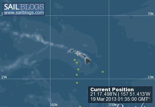
18 March 2013 | 21 17.498'N:157 51.413'W, Kewalo Basin Harbor
17 March 2013 | 21 17.498'N:157 51.413'W, Kewalo Basin Harbor
17 March 2013 | 21 17.498'N:157 51.413'W, Kewalo Basin Harbor
13 March 2013 | 19 40.918'N:158 36.215'W, Pacific Ocean
12 March 2013 | 19 05.000'N:158 06.000'W, Pacific Ocean
11 March 2013 | 17 22.285'N:157 41.829'W, Pacific Ocean
10 March 2013 | 17 22.285'N:157 41.829'W, Pacific Ocean
10 March 2013 | 16 04.062'N:158 04.387'W, Pacific Ocean
09 March 2013 | 16 04.062'N:158 04.387'W, Pacific Ocean
08 March 2013 | 14. 19.437'N:158. 30.372'W, Pacific Ocean
05 March 2013 | 07 55.901'N:157 15.005'W, Pacific Ocean
04 March 2013 | 07 55.901'N:157 15.005'W, Pacific Ocean
03 March 2013 | 06 06.037'N:156 33.739'W, Pacific Ocean
02 March 2013 | 05 23.321'N:155 45.694'W, Pacific Ocean
01 March 2013 | 04 33.134'N:154 41.962'W, Pacific Ocean
28 February 2013 | 03 18'N:153 30'W, Pacific Ocean
25 February 2013 | 00 00.00'N:151 32.958'W, Pacific Ocean
24 February 2013 | 01 54.872'S:151 03.922'W, South Pacific Ocean
Day 17 Equator to Hawaii
28 February 2013 | 03 18'N:153 30'W, Pacific Ocean
Lynn
Sorry I missed a day. Yesterday was a day of major squall lines, flunky winds, cross swells and clearing the tail of the ITCZ! Night before last, right at sunset, we had winds out of the north at 15 to 18. That was not in the play book! We needed to make some easting and headed off at 90/110 degrees mag.Running about 4 kts, on my watch, I looked at the handheld gps and longitude was increasing! Wait a minute!,we're heading east and the numbers should be decreasing! Speed over ground was 1.8 to 2.5 and we are caught in a fast moving current. Wind shifted to the east a tad, and then tried to fall off to the northeast to angle across the current. Finally around dawn, we were free1 and the northeast winds came back. Very strange to see yourself sailing backwards!! After clearing another mondo squall line, we broke free of the ITCZ with deep blue water and 20 kt. ne trade winds. Still in a transition zone and more than likely be that way for another day, as we still have some 20 m ile long squall lines but not as many, plus we are able to either speed up or slow down to miss the worst of them. Some are pretty wild, in excess of 45kts, but others we sail through and get a freash water shower! feels good to rid ourselves of the salt crust and Buckaroo gets a nice bath also. Dan, I'm working on your list and at this time we have around 1,000 miles to go. If the trades hold up, 9 to 11 days from now untill Oahu. We may have to burn a day to tack east for a straight shot at Diamond Head. I'll send it out next time I charge the batteries. Be real nice once we are out of this zone so the seas settle down into the regular Northeast trade pattern and all these 3 to 5 feet cross waves leave, then we can really make some time!.Still,we covered 100 miles the last 24 hours but 120 to 140 will sure be better. I can taste a cheesburger with fries and acold beer right now! To Andy, find a sailing club and start on studying the ASA, American Sailing Association, courses. Most sailing clubs have their members study and take the test so they can advance from the little boats to bigger ones. Also hit the yacht clubs during their weekday beer can races as a pick up crew member. Hope that answers your question. One more thing, I'll need a crew member for the Oahu to San diego leg, experience and able body a plus. Till tomorrow, Lynn
buckaroo@ocens.net
buckaroo@ocens.net
Comments
| Vessel Name: | Buckaroo |
| Vessel Make/Model: | Beneteau 393 |
| Hailing Port: | San Diego |
| Crew: | Lynn and George |
| About: | Lynn runs a delivery company, Eastern Pacific Yacht Delivery Service, based out of Morro Bay,Ca. George is a climatologist from Oregon |
Buckaroo's Photos - Main
 |
 |
Buckaroo in Raiate'a
Who: Lynn and George
Port: San Diego
Favorite Links
No Links Added Yet