Cascadia Cruising Blog
| Vessel Name: | Cascadia |
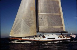
| Vessel Make/Model: | Schumacher 77 |
| Hailing Port: | Shaw Island, WA |
20 June 2015
19 June 2015
19 June 2015
19 June 2015
22 June 2013 | SF
22 June 2013 | 37 47.6 N 122 16.7 W
20 June 2013 | Near OR/CA Border
19 June 2013
19 June 2013
19 June 2013 | Astoria
17 June 2013 | Tatoosh Island
16 June 2013
16 June 2013
16 June 2013
16 June 2013
08 June 2013
16 May 2013 | Shilshole
Recent Blog Posts
19 June 2015
Depart Port Hardy for Bull Harbor
1700 Cascadia and Serendipity depart Port Hardy for Bull Harbor to anchor for night and plan to round Cape Scott in the morning to the West Coast of Vancouver Island.
19 June 2015
Circumnavigation of Vancouver Island
On the first leg of circumnavigation of Vancouver Island, Cascadia departed Shilshole on June 10. After a several day stay in Campbell River for final stocking of fresh foods and BC wine, Cascadia arrived in Port Hardy at the northern end of Vancouver Island on June 18. Serendipity joined Cascadia in Campbell River and then Port Hardy for a joint adventure.
Winter Harbor Sunset Photo of Cascadia from Drone
20 June 2015
Depart Bull Harbor, Round Cape Scott, Arrive Winter Harbor
20 June 2015
0500 Depart Bull Harbor
0700 Cape Scott
1040 Arrive Winter Harbor
2200 Winter Harbor sunset photo by Craig from his drone
0700 Cape Scott
1040 Arrive Winter Harbor
2200 Winter Harbor sunset photo by Craig from his drone
Depart Port Hardy for Bull Harbor
19 June 2015
1700 Cascadia and Serendipity depart Port Hardy for Bull Harbor to anchor for night and plan to round Cape Scott in the morning to the West Coast of Vancouver Island.
Current Weather at 1900 (South Brooks Buoy): Overcast, Visabiity 16 NM, Wind W 4K, Wave Ht 0.9m, Wave Period 6s, Temp 11C, Water Temp 14C, Sunset 21:46.
Weather forecast for tomorrow at 0600 (Cape Scott Light): Wind SW 5, Wave Ht 1M, Temp 6C, Chance Rain 60%.
Winds building by Sunday to N 15 to 25K.
19 June 2015
CASCADIA
6.18.15
50.72834° / -127.4721°
Status: MMSI: 366947650
Call Sign: WDB7761
Flag: USA (US)
Last Known Port: PORT HARDY [CA] (2015-06-18 23:08:00)
Previous Ports: CAMPBELL RIVER [BC]; PORT TOWNSEND [US] (2015-06-11 15:14:00)
6.18.15
50.72834° / -127.4721°
Status: MMSI: 366947650
Call Sign: WDB7761
Flag: USA (US)
Last Known Port: PORT HARDY [CA] (2015-06-18 23:08:00)
Previous Ports: CAMPBELL RIVER [BC]; PORT TOWNSEND [US] (2015-06-11 15:14:00)
Circumnavigation of Vancouver Island
19 June 2015
On the first leg of circumnavigation of Vancouver Island, Cascadia departed Shilshole on June 10. After a several day stay in Campbell River for final stocking of fresh foods and BC wine, Cascadia arrived in Port Hardy at the northern end of Vancouver Island on June 18. Serendipity joined Cascadia in Campbell River and then Port Hardy for a joint adventure.
Day 6
22 June 2013 | SF
Tom

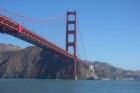
We passed Pt Reyes at O530 with winds of about 10 knots as the sun rose for a very sunny day. We passed under the Golden Gate Bridge at 0800 with bright sunlight and moderate winds and arrived at our moorage at Jack London Square in Oakland at 0900.
Gallery not available