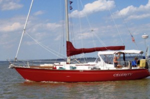
Celerity Sailing
21 October 2013
20 October 2013
12 October 2013
21 September 2013 | Sevrin River, Mobjack Bay VA
14 September 2013 | Fishing Bay, VA
23 August 2013 | Solomons Island, MD
18 August 2013 | Swan Creek, Rock Hall, MD
13 August 2013
31 July 2013 | Chesapeake City, MD
24 July 2013
12 July 2013 | St. Micheals and Rock Hall
01 July 2013 | St. Michaels
19 June 2013 | Wye River, Eastern Shore Maryland
17 June 2013 | Baltimore and Whitehall Bay
09 June 2013
05 June 2013
02 June 2013
24 May 2013
23 May 2013 | Tuckahoe Point
Farwell to the Chesapeake Bay; Hello to the ICW
12 October 2013
Hard to believe Celerity has completed her last leg in the Chesapeake Bay for 2013! Seems I only just tossed my dock lines and pulled out of Jordan Creek but that was over 4 months ago........This last leg was a doozy...wind was 10-15, gusting to 20, out of the North, mostly on the port stern quarter but was shifty so occasionally Celerity would run directly downwind for a few moments .
Chester, the autopilot, was doing a fair job of keeping course but he could not always respond fast enough in the shifty wind to keep the boat from rolling. I had elected to motor sail with just the head sail (no main) to help control any rolling and to eliminate the possibility of jibing (occurs when the wind shifts from one side of the stern to the other, throwing the main sail from one side of boat to other. Can be dangerous and cause damage to the boat if uncontrolled.)
As we worked our way south towards Norfolk, the waves increased to 2-3 ft with breaking tops, still on the port stern quarter, but with occasional rogue waves which hit Celerity on her beam......the first of these caused the boat to roll from rubrail to rubrail (the rubrail is just below the edge of the deck) with crashing sounds coming from the cabin.....I thought I had stored stuff below well enough to avoid having items fall but guess not good enough for the conditions! Fortunately, nothing broke; just messy below with CD's, some plastic glasses, sofa pillows, magazines and papers on the floor. Could have been worse! Neither Abigail nor I were happy campers! So I disengaged Chester and hand steered for a while since I could feel the boat's movement on the waves in time to adjust the helm to prevent a severe roll......but hand steering in these conditions can be very tiring.
I was very glad to say good-bye to the Bay with its rollicking conditions and turn into the entrance to the Elizabeth River at Hampton Roads! The entrance crosses over one of the tunnels for the Bay Bridge Tunnel system. I imagine the cars and trucks that are zooming along under me! At its entrance, the river is very open and wide to the Bay so not much protection from the wind and waves on the stern but I knew that conditions would eventually moderate as I moved further in, past "battleship row", towards the Norfolk waterfront. The land blocked some of the wind, allowing the waves to calm some, so conditions improved.
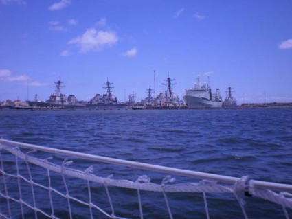
I was tired from hand steering, having to counteract the wave action and was relieved to put Chester back on duty in the moderating conditions. We passed through "battleship row" where numerous navy and and then cargo ships line the sides of the river. Never ceases to astound me at how closely all boating traffic passes to the Navy ships, including smaller aircraft carriers, ships sprouting arrays of antennas, and many other types (see pic). But all dwarfed Celerity. As always, a Navy patrol boat with blue light flashing and a machine gun mounted on the foredeck, motored slowly along, parallel to my course, staying between me and the Navy ships. I expect the Feds wish they could close the waterway to non-military traffic but not realistic since commercial and recreational vessels have to use it to travel from Norfolk to the Bay; there is no other route.
I had considered not stopping in Norfolk but continuing on to Great Bridge and spending 2-3 days tied up to a free dock. But by the time I reached the anchorage at Hospital Point, on the Norfolk waterfront, I did not feel like traveling another 3 hours and several opening bridges to reach Great Bridge. Hospital Point is a very popular anchorage, literally at the edge of the ICW, behind a couple of red channel markers. On charts, it looks shallow and small but is actually a wide band of deep water (10-15 feet) that can accommodate many boats (especially when the crab pots are absent!). It is called Hospital Point because it is located immediately in front of the 10ish-story-tall Portsmouth Naval Hospital.
When I was last at Hospital Point in late May, the anchorage was wonderfully free of crab pots. Not this time! Maybe crabbers set them in the fall.....for whatever reason, there were a ton of pots, forcing me to weave around them. Goal was to find a spot where neither the anchor nor prop would snag a pot. I found a small pot-free spot and dropped the anchor, nestling Celerity in between the pots. I could only hope that we would not "catch" one when I started the engine and raised the anchor. I have heard horror stories of pots getting entangled in props or rudders, requiring the captain to go overboard with a knife to cut the lines. That is one experience I hope to avoid!
After a couple of nights at Hospital Point, I upped anchor (none of the pots were dragged alond with us so free and clear!) and headed to Great Bridge Lock and Bridge. There are numerous bridges on the ICW: a few are high-rise bridges (they have at least 65 feet of vertical clearance under them and don't open) and several are opening bridges (less than 65 feet clearance; some have less than 20 feet!). There are also several railroad bridges but these are routinely left open and only close if a train is coming. The opening bridges open on a set published schedule, typically on the hour and half-hour. Some open by rotating around a fixed center point (swing bridge), others (bascule or drawbridge) open by swinging upward.
The first opening bridge south of Norfolk is a bascule bridge at Gilmerton and has a railroad bridge immediately south of it. There were several motor yachts and sailboats circling around or idling in place in front of the bridge, waiting for it to open. This particular bridge is closed from 0630-0930 for rush hour so we were all there for the 0930 opening. The bridge tender always wants the boats to get packed in very close to each other and close to the bridge ("come on up, captain!") before it opens. They don't want to hold the bridge open for longer than absolutely necessary since the line of cars piles up behind the closed gates. Boats don't have brakes and the bridge operators do not always open on the exact minute.....so we all jockey in place, trying not to hit another boat or the bridge! It can be some anxious sphincter-tightening moments....As I am thinking "come on, open for heaven's sake!), the bridge tender announces on the VHF radio that the opening will be delayed... a train will be coming over the RR bridge ("you've got to be kidding!").....so the waiting boats continue to carefully jockey, circle, weave, reverse slowly in a narrow channel to avoid any collisions, while trying to hold position. The bridge finally opens without any announcement...so we all move through in a line, in orderly fashion...the motor yachts first since they are faster, followed by the slower sailboats.
The motor yachts zoom away, headed to the next bridge, leaving the sail boats in their wakes....The three sailboats travel in a cluster, reaching each of the following opening bridges together. We catch up to the motor yachts at the Great Bridge lock and all lock-through together. A couple of sail boats in my "cluster" stop at the free dock while the motor yachts are probably headed for marinas further south.
I decided not to stop at the Great Bridge free dock but headed on to Pungo Ferry to anchor overnight which is close to the north end of the Currituck Sound. This allowed me an early morning crossing of the Sound, hopefully in benign conditions. There is only an old abandoned decrepit marina at Pungo Ferry. ....otherwise it seems to be just a name on the chart. No trespassing signs are posted on what remains of the dock and office...it is tempting to tie side-to but the dock is in terrible shape with rotting boards and leaning pilings but think not.......
In 2009, I was able to find enough deep water behind a red marker at Pungo Ferry....I tried to find that deep pocket of water but it was elusive.....trying to avoid the crab pots might have been the problem........so I decided to try the other side of the ICW in hopes of finding enough water behind a green marker amongst the crab pots....If I could not find a spot, I had no choice but to run the Currituck that afternoon but the conditions would be undesirable. Hallelujah! I was able to anchor, nestled among the pots, with about a foot under my keel! A foot is as good as a mile!
The wind is predicted to continue to blow out of the north which will keep me safely parallel to, and behind the green marker, out of the channel. (I did not have any Wifi so thanks to Bob B. for being Celerity's personal weatherman and providing up-to-date weather forecasts.) I needed to stay parallel to, and out of the channel, since commercial traffic, tugs pushing a barge, use the ICW, day and night, to travel between points to the north and south. The boat didn't move out of position all night which is a good thing since a tug and barge passed in the night......I couldn't believe that the loud rumble of the approaching tug didn't wake me up....I was awakened when the wake lightly rocked Celerity..then I heard the rumbling engine as the tug receded in the distance!
I am up early in the morning, just as the sun peeks over the horizon. I want to get across the Currituck early in the morning before the wind pipes up. Fog is rising off the water and I can see my breath in the chilly air. Brrrr! Reminders that fall is not far away; the gloves, jacket and hat feel good. I leave Abbie below where it is warmer, out of the light north wind, still coming from behind me, blowing straight into the cockpit. As I raise the anchor, and motor away, I am relieved to see that none of the crab pots that surrounded me are coming with me! Currituck Sound crossing is easy-peasy...conditions are benign with small wavelets and a light wind. Later in the morning, the wind shifts to the SSW at 5-10, putting on my nose. I will anchor at Buck Island to give me an early morning crossing of the Albemarle Sound.....maybe with the same benign conditions as for the Currituck!
Chester, the autopilot, was doing a fair job of keeping course but he could not always respond fast enough in the shifty wind to keep the boat from rolling. I had elected to motor sail with just the head sail (no main) to help control any rolling and to eliminate the possibility of jibing (occurs when the wind shifts from one side of the stern to the other, throwing the main sail from one side of boat to other. Can be dangerous and cause damage to the boat if uncontrolled.)
As we worked our way south towards Norfolk, the waves increased to 2-3 ft with breaking tops, still on the port stern quarter, but with occasional rogue waves which hit Celerity on her beam......the first of these caused the boat to roll from rubrail to rubrail (the rubrail is just below the edge of the deck) with crashing sounds coming from the cabin.....I thought I had stored stuff below well enough to avoid having items fall but guess not good enough for the conditions! Fortunately, nothing broke; just messy below with CD's, some plastic glasses, sofa pillows, magazines and papers on the floor. Could have been worse! Neither Abigail nor I were happy campers! So I disengaged Chester and hand steered for a while since I could feel the boat's movement on the waves in time to adjust the helm to prevent a severe roll......but hand steering in these conditions can be very tiring.
I was very glad to say good-bye to the Bay with its rollicking conditions and turn into the entrance to the Elizabeth River at Hampton Roads! The entrance crosses over one of the tunnels for the Bay Bridge Tunnel system. I imagine the cars and trucks that are zooming along under me! At its entrance, the river is very open and wide to the Bay so not much protection from the wind and waves on the stern but I knew that conditions would eventually moderate as I moved further in, past "battleship row", towards the Norfolk waterfront. The land blocked some of the wind, allowing the waves to calm some, so conditions improved.
I was tired from hand steering, having to counteract the wave action and was relieved to put Chester back on duty in the moderating conditions. We passed through "battleship row" where numerous navy and and then cargo ships line the sides of the river. Never ceases to astound me at how closely all boating traffic passes to the Navy ships, including smaller aircraft carriers, ships sprouting arrays of antennas, and many other types (see pic). But all dwarfed Celerity. As always, a Navy patrol boat with blue light flashing and a machine gun mounted on the foredeck, motored slowly along, parallel to my course, staying between me and the Navy ships. I expect the Feds wish they could close the waterway to non-military traffic but not realistic since commercial and recreational vessels have to use it to travel from Norfolk to the Bay; there is no other route.
I had considered not stopping in Norfolk but continuing on to Great Bridge and spending 2-3 days tied up to a free dock. But by the time I reached the anchorage at Hospital Point, on the Norfolk waterfront, I did not feel like traveling another 3 hours and several opening bridges to reach Great Bridge. Hospital Point is a very popular anchorage, literally at the edge of the ICW, behind a couple of red channel markers. On charts, it looks shallow and small but is actually a wide band of deep water (10-15 feet) that can accommodate many boats (especially when the crab pots are absent!). It is called Hospital Point because it is located immediately in front of the 10ish-story-tall Portsmouth Naval Hospital.
When I was last at Hospital Point in late May, the anchorage was wonderfully free of crab pots. Not this time! Maybe crabbers set them in the fall.....for whatever reason, there were a ton of pots, forcing me to weave around them. Goal was to find a spot where neither the anchor nor prop would snag a pot. I found a small pot-free spot and dropped the anchor, nestling Celerity in between the pots. I could only hope that we would not "catch" one when I started the engine and raised the anchor. I have heard horror stories of pots getting entangled in props or rudders, requiring the captain to go overboard with a knife to cut the lines. That is one experience I hope to avoid!
After a couple of nights at Hospital Point, I upped anchor (none of the pots were dragged alond with us so free and clear!) and headed to Great Bridge Lock and Bridge. There are numerous bridges on the ICW: a few are high-rise bridges (they have at least 65 feet of vertical clearance under them and don't open) and several are opening bridges (less than 65 feet clearance; some have less than 20 feet!). There are also several railroad bridges but these are routinely left open and only close if a train is coming. The opening bridges open on a set published schedule, typically on the hour and half-hour. Some open by rotating around a fixed center point (swing bridge), others (bascule or drawbridge) open by swinging upward.
The first opening bridge south of Norfolk is a bascule bridge at Gilmerton and has a railroad bridge immediately south of it. There were several motor yachts and sailboats circling around or idling in place in front of the bridge, waiting for it to open. This particular bridge is closed from 0630-0930 for rush hour so we were all there for the 0930 opening. The bridge tender always wants the boats to get packed in very close to each other and close to the bridge ("come on up, captain!") before it opens. They don't want to hold the bridge open for longer than absolutely necessary since the line of cars piles up behind the closed gates. Boats don't have brakes and the bridge operators do not always open on the exact minute.....so we all jockey in place, trying not to hit another boat or the bridge! It can be some anxious sphincter-tightening moments....As I am thinking "come on, open for heaven's sake!), the bridge tender announces on the VHF radio that the opening will be delayed... a train will be coming over the RR bridge ("you've got to be kidding!").....so the waiting boats continue to carefully jockey, circle, weave, reverse slowly in a narrow channel to avoid any collisions, while trying to hold position. The bridge finally opens without any announcement...so we all move through in a line, in orderly fashion...the motor yachts first since they are faster, followed by the slower sailboats.
The motor yachts zoom away, headed to the next bridge, leaving the sail boats in their wakes....The three sailboats travel in a cluster, reaching each of the following opening bridges together. We catch up to the motor yachts at the Great Bridge lock and all lock-through together. A couple of sail boats in my "cluster" stop at the free dock while the motor yachts are probably headed for marinas further south.
I decided not to stop at the Great Bridge free dock but headed on to Pungo Ferry to anchor overnight which is close to the north end of the Currituck Sound. This allowed me an early morning crossing of the Sound, hopefully in benign conditions. There is only an old abandoned decrepit marina at Pungo Ferry. ....otherwise it seems to be just a name on the chart. No trespassing signs are posted on what remains of the dock and office...it is tempting to tie side-to but the dock is in terrible shape with rotting boards and leaning pilings but think not.......
In 2009, I was able to find enough deep water behind a red marker at Pungo Ferry....I tried to find that deep pocket of water but it was elusive.....trying to avoid the crab pots might have been the problem........so I decided to try the other side of the ICW in hopes of finding enough water behind a green marker amongst the crab pots....If I could not find a spot, I had no choice but to run the Currituck that afternoon but the conditions would be undesirable. Hallelujah! I was able to anchor, nestled among the pots, with about a foot under my keel! A foot is as good as a mile!
The wind is predicted to continue to blow out of the north which will keep me safely parallel to, and behind the green marker, out of the channel. (I did not have any Wifi so thanks to Bob B. for being Celerity's personal weatherman and providing up-to-date weather forecasts.) I needed to stay parallel to, and out of the channel, since commercial traffic, tugs pushing a barge, use the ICW, day and night, to travel between points to the north and south. The boat didn't move out of position all night which is a good thing since a tug and barge passed in the night......I couldn't believe that the loud rumble of the approaching tug didn't wake me up....I was awakened when the wake lightly rocked Celerity..then I heard the rumbling engine as the tug receded in the distance!
I am up early in the morning, just as the sun peeks over the horizon. I want to get across the Currituck early in the morning before the wind pipes up. Fog is rising off the water and I can see my breath in the chilly air. Brrrr! Reminders that fall is not far away; the gloves, jacket and hat feel good. I leave Abbie below where it is warmer, out of the light north wind, still coming from behind me, blowing straight into the cockpit. As I raise the anchor, and motor away, I am relieved to see that none of the crab pots that surrounded me are coming with me! Currituck Sound crossing is easy-peasy...conditions are benign with small wavelets and a light wind. Later in the morning, the wind shifts to the SSW at 5-10, putting on my nose. I will anchor at Buck Island to give me an early morning crossing of the Albemarle Sound.....maybe with the same benign conditions as for the Currituck!
Comments
| Vessel Name: | Celerity |
| Vessel Make/Model: | Morgan 382 |
| Hailing Port: | Jordan Creek |
| Crew: | Melinda and Abigail |
| About: | Canine first mate. |
Gallery not available
Who: Melinda and Abigail
Port: Jordan Creek