C'est la Vie
C'est la Vie
Port: Everglades City, FL
Past Posts:
31 January 2010
02 September 2008 | Sunset Island, FL
01 September 2008 | Gulf of Mexico
26 August 2008 | Coconut Grove, FL
25 August 2008 | Bahamas
24 August 2008 | Nassau Harbor
24 August 2008 | Atlantis Resort, Nassau
24 August 2008 | Atlantis Resort, Nassau
24 August 2008 | Atlantis Resort
24 August 2008 | Atlantis Resort, Nassau
24 August 2008 | Atlantis Resort, Nassau
23 August 2008 | Atlantis Resort, Nassau
23 August 2008 | Nassau
23 August 2008 | Nassau
22 August 2008 | Exumas
21 August 2008 | Exumas
20 August 2008 | Lee Stocking Island
20 August 2008 | Exumas
18 August 2008 | Stocking Island, Exumas
16 August 2008 | Elizabeth Harbor
On the Little Bahama Banks
25 June 2008 | Mangrove Cay
Jeff

Eager to get started and unwilling to pretend to sleep any longer we arose early and were underway at dawn on the 24th. Evening thunder storms and rolling seas afforded us little sleep to prepare for our crossing from the Islands of Bimini to the famous "West End" of Grand Bahama Island. This 60NM stretch of water is the Gulf Stream's little cousin. The deep blue waters of the North West Providence Channel stretch on below our keel to depths over 2000 feet and the ocean currents feed the Gulf Stream at 2+ knots. We are fortunate to have moderate seas running around four feet and 18 knot winds from the east. C'est la Vie celebrates the excellent sailing weather and averages over 6.5 knots sailing on a close reach. As we drawn within 5NM of West End and the afternoon begins to wane into evening, building thunder storms over the Little Bahama Banks begin to steal our winds.
As the storms grow, towering to massive columns that glow orange in the setting sun, we abort our attempt to cross the shoals that guard the entrance to the Banks. We retreat to a tiny, crowded anchorage just north of the harbor at West End. Within minutes of setting the anchor Anne and I are below decks hiding from the squall.
The torrents of rain flatten out the seas and the storms are short lived. Tired from an exhilarating day of sailing and little sleep the previous night, Anne and I crash out early.
The 25th arrives with few clouds and little wind. We must wait until mid morning to depart. Navigating the four miles of shallow water between Indian Rock and Barracuda Shoals will require what charts refer to as "visual piloting". Mariners navigating these waters must dodge the shallows by visually judging the depth. This is done by the color of the water and requires the sun be overhead. Visual piloting is impossible if the sun in the captain's eyes or if the day is cloudy. The rules go something like this... blue- deep to very deep; shades of green - getting shallow but passable; white is a shallow sand bar; brown is shallow rock. Sounds simple? It is, until you throw in grass banks the change to bottom color, clouds overhead that cast shadows and change the colors of the water; and the obnoxious, massive sport fishing boats that run the shoals at high speed via the GPS coordinates from a buddy or lack of concern for running aground and taking smaller craft down with them.
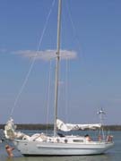
We cross the shoals with ease and set our course for Mangrove Cay (sounds like home.) Unfortunately the trade winds have set in for the afternoon and our 20NM course to is on a heading of 68 degrees. Otto does a fine job of steering as C'est la Vie pounds through the chop created by the shallow waters and headwinds.
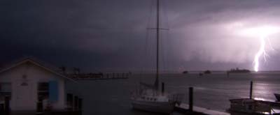
Again timing is everything. Anne finished grilling dinner (see image included) and I exited the water just as this evenings thunderstorm rolled in. I was washing down with fresh rain water in the cockpit when a bolt of lightning arced by too close for comfort. I dove below decks, turned off our electrical systems, and began to scan the anchorage to see which of the five other boats anchored alongside us had been struck. Everyone appeared to be ok. It amazes me that sailboats are not struck more often - I am now knocking on wood. The storm persisted through the evening. Guess this is why they call it the rainy season.
P.S. Check out Anne's herb garden on the left in the image. Anne is doing quite well growing mint, rosemary, and basil on board.
As the storms grow, towering to massive columns that glow orange in the setting sun, we abort our attempt to cross the shoals that guard the entrance to the Banks. We retreat to a tiny, crowded anchorage just north of the harbor at West End. Within minutes of setting the anchor Anne and I are below decks hiding from the squall.
The torrents of rain flatten out the seas and the storms are short lived. Tired from an exhilarating day of sailing and little sleep the previous night, Anne and I crash out early.
The 25th arrives with few clouds and little wind. We must wait until mid morning to depart. Navigating the four miles of shallow water between Indian Rock and Barracuda Shoals will require what charts refer to as "visual piloting". Mariners navigating these waters must dodge the shallows by visually judging the depth. This is done by the color of the water and requires the sun be overhead. Visual piloting is impossible if the sun in the captain's eyes or if the day is cloudy. The rules go something like this... blue- deep to very deep; shades of green - getting shallow but passable; white is a shallow sand bar; brown is shallow rock. Sounds simple? It is, until you throw in grass banks the change to bottom color, clouds overhead that cast shadows and change the colors of the water; and the obnoxious, massive sport fishing boats that run the shoals at high speed via the GPS coordinates from a buddy or lack of concern for running aground and taking smaller craft down with them.
We cross the shoals with ease and set our course for Mangrove Cay (sounds like home.) Unfortunately the trade winds have set in for the afternoon and our 20NM course to is on a heading of 68 degrees. Otto does a fine job of steering as C'est la Vie pounds through the chop created by the shallow waters and headwinds.
Again timing is everything. Anne finished grilling dinner (see image included) and I exited the water just as this evenings thunderstorm rolled in. I was washing down with fresh rain water in the cockpit when a bolt of lightning arced by too close for comfort. I dove below decks, turned off our electrical systems, and began to scan the anchorage to see which of the five other boats anchored alongside us had been struck. Everyone appeared to be ok. It amazes me that sailboats are not struck more often - I am now knocking on wood. The storm persisted through the evening. Guess this is why they call it the rainy season.
P.S. Check out Anne's herb garden on the left in the image. Anne is doing quite well growing mint, rosemary, and basil on board.
| Vessel Name: | Cest la Vie |
| Vessel Make/Model: | 1966 Charlie Morgan 34 |
| Hailing Port: | Everglades City, FL |
| About: | Anne - thirtysomething culinary godess that won't admit to being a fine sailor. Jeff - thirtysomething jack of all trades that constantly reminds Anne she is a fine sailor. Carlie - nine year old Jack Russell that loves to watch the dolphins. |
| Extra: | Currently our winters are spent working for the North Carlina Outward Bound School based on Indian Key Pass in Everglades City, FL. Our summers are spent in the Outer Banks of NC running the Outward Bound Schools sea kayak programs along the Cape Lookout National Seashore. |
Gallery not available
C'est la Vie
Port: Everglades City, FL