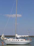
C'est la Vie
C'est la Vie
Port: Everglades City, FL
Past Posts:
31 January 2010
02 September 2008 | Sunset Island, FL
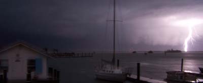
01 September 2008 | Gulf of Mexico
26 August 2008 | Coconut Grove, FL
25 August 2008 | Bahamas
24 August 2008 | Nassau Harbor
24 August 2008 | Atlantis Resort, Nassau
24 August 2008 | Atlantis Resort, Nassau
24 August 2008 | Atlantis Resort
24 August 2008 | Atlantis Resort, Nassau
24 August 2008 | Atlantis Resort, Nassau
23 August 2008 | Atlantis Resort, Nassau
23 August 2008 | Nassau
23 August 2008 | Nassau
22 August 2008 | Exumas
21 August 2008 | Exumas
20 August 2008 | Lee Stocking Island
20 August 2008 | Exumas
18 August 2008 | Stocking Island, Exumas
16 August 2008 | Elizabeth Harbor
Hawksbill Cay II
29 July 2008 | Exumas
Jeff
This image is from the same bluff as the preceding shot, but it is looking to the south.
Anne and I spent the morning exploring some ruins from a Loyalist Settlement along one of the high ridges in the mid section of Hawksbill. The community was founded in 1785 by Loyalists fleeing persecution and torment in the newly independent United States of American. The British Crown offered land in the Bahamas to citizens that remained loyal to the crown throughout the American Revolution. Many of these families opted for land in the Bahamas and fled south on sailing ships. It is difficult to believe they were please with what they found in this new land. While in modern times aboard our high tech vessels this land and it waters appear to be a playground. Making a life ashore on the arid, rocky islands in the late 1700's would be difficult. The Hawksbill settlement survived until 1900 when its final citizen bled to death from a barracuda bite suffered with fishing in the flats. Stone walls, stone fences, and beehive shaped stone ovens at all that remain of the settlement on Hawksbill.
While exploring the ruins, Anne and I happened upon a geocash. We signed the logbook and read notes from others that found the geocash. This discovery has peaked my interest in the geocashing phenomenon.
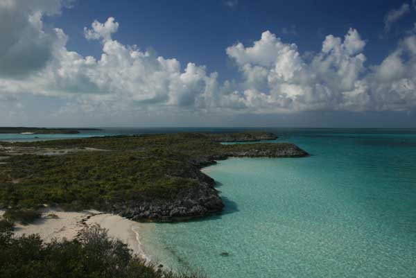
Moving south from Hawksbill to Wardwrick Wells, we chose to take a short, yet challenging route to the Exuma Sound. As seen in the image above the water depth can be judged by the color of water. Shallow to deep goes from white to blue with greens in the 4 to 6 foot range. Black can mean grass beds or coral heads. Browns are bad news... see brown you will go aground is the local rhyme. With the tide at full flood we motored southeastward towards Little Cistern Cut. I bounced between reading the charts and standing atop the bow sprit attempting to read the water. Anne remained at the helm and deftly steered while I used hand signals to indicate direction and speed. The current ran so strong between the rocky outcroppings that we were only able to make 1.5 knots as we bounced through the standing waves. Most of the route proved deep, but intricate. We never observed less than 6.5 feet of water. Anne did an outstanding job of piloting C'est la Vie.
Anne and I spent the morning exploring some ruins from a Loyalist Settlement along one of the high ridges in the mid section of Hawksbill. The community was founded in 1785 by Loyalists fleeing persecution and torment in the newly independent United States of American. The British Crown offered land in the Bahamas to citizens that remained loyal to the crown throughout the American Revolution. Many of these families opted for land in the Bahamas and fled south on sailing ships. It is difficult to believe they were please with what they found in this new land. While in modern times aboard our high tech vessels this land and it waters appear to be a playground. Making a life ashore on the arid, rocky islands in the late 1700's would be difficult. The Hawksbill settlement survived until 1900 when its final citizen bled to death from a barracuda bite suffered with fishing in the flats. Stone walls, stone fences, and beehive shaped stone ovens at all that remain of the settlement on Hawksbill.
While exploring the ruins, Anne and I happened upon a geocash. We signed the logbook and read notes from others that found the geocash. This discovery has peaked my interest in the geocashing phenomenon.
Moving south from Hawksbill to Wardwrick Wells, we chose to take a short, yet challenging route to the Exuma Sound. As seen in the image above the water depth can be judged by the color of water. Shallow to deep goes from white to blue with greens in the 4 to 6 foot range. Black can mean grass beds or coral heads. Browns are bad news... see brown you will go aground is the local rhyme. With the tide at full flood we motored southeastward towards Little Cistern Cut. I bounced between reading the charts and standing atop the bow sprit attempting to read the water. Anne remained at the helm and deftly steered while I used hand signals to indicate direction and speed. The current ran so strong between the rocky outcroppings that we were only able to make 1.5 knots as we bounced through the standing waves. Most of the route proved deep, but intricate. We never observed less than 6.5 feet of water. Anne did an outstanding job of piloting C'est la Vie.
Comments
| Vessel Name: | Cest la Vie |
| Vessel Make/Model: | 1966 Charlie Morgan 34 |
| Hailing Port: | Everglades City, FL |
| About: | Anne - thirtysomething culinary godess that won't admit to being a fine sailor. Jeff - thirtysomething jack of all trades that constantly reminds Anne she is a fine sailor. Carlie - nine year old Jack Russell that loves to watch the dolphins. |
| Extra: | Currently our winters are spent working for the North Carlina Outward Bound School based on Indian Key Pass in Everglades City, FL. Our summers are spent in the Outer Banks of NC running the Outward Bound Schools sea kayak programs along the Cape Lookout National Seashore. |
Gallery not available
C'est la Vie
Port: Everglades City, FL