C'est la Vie
C'est la Vie
Port: Everglades City, FL
Past Posts:
31 January 2010
02 September 2008 | Sunset Island, FL
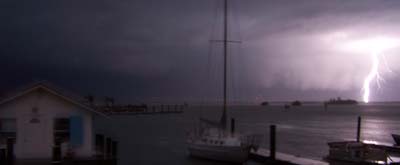
01 September 2008 | Gulf of Mexico
26 August 2008 | Coconut Grove, FL
25 August 2008 | Bahamas
24 August 2008 | Nassau Harbor
24 August 2008 | Atlantis Resort, Nassau
24 August 2008 | Atlantis Resort, Nassau
24 August 2008 | Atlantis Resort
24 August 2008 | Atlantis Resort, Nassau
24 August 2008 | Atlantis Resort, Nassau
23 August 2008 | Atlantis Resort, Nassau
23 August 2008 | Nassau
23 August 2008 | Nassau
22 August 2008 | Exumas
21 August 2008 | Exumas
20 August 2008 | Lee Stocking Island
20 August 2008 | Exumas
18 August 2008 | Stocking Island, Exumas
16 August 2008 | Elizabeth Harbor
on the banks side
05 August 2008 | Bitter Guana Cay
Jeff
PROLOGUE: Mid morning we departed Staniel Cay on the banks side of the cays. The banks side of the Exumas refers to the western think, towards Cuba, side of the cays. The waters in this area, referred to as the Great Bahamas Bank, cover a vast plateau of limestone. The Great Bahamas Bank is the world largest deposit of limestone. Surrounding the plateau are staggeringly deep ocean waters. Much like the high desert plateaus in US western states the submarine plateaus of the Bahamas have deep, vast canyons that extend unseen. The characteristics of weather, wave action, & tidal currents vary greatly between the shallow banks and the deep water sounds and channels. When I say deep we are not talking hundreds of feet we are measuring depths in miles. We would be able to drop a penny overboard in the Providence Channel and be snug in our anchorage off Egg Island before the penny reached the sea bed.
I digress. Along the Exumas we have a choice of banks side or sound side travel. Banks travel is west of the cays in shallow waters that require us to be ever vigilant for random coral heads and often take indirect routes to avoid sandbars, coral reefs, and groups of cays. Traveling on the eastern side of the cays in the Exuma Sound is affords more direct routes since � NM offshore can place us in over 1000 feet of water, but traveling in the sound can be rough and egress requires transiting cuts in the island chain. Changes in tides and winds can quickly make the cuts impassable. Well if you have read this far along (thanks), I now get back to our travels.
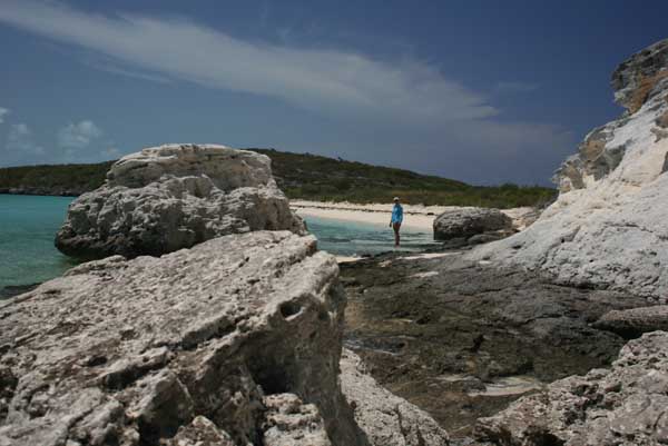
PLOT: 18 knot southeast winds convinced us to take the long route along the banks side to Black Point settlement. We were motor sailing windward under the mainsail and taking quite a bit of spray in the steep chop building on the banks. We tacked eastward to take advantage of a bit of lee off the cays. Our shoreward tack took us along Bitter Guana Cay. The west facing white and black cliffs along the northern end of Bitter Guana created a calm anchorage. Awed by the beauty of the calm blue waters meeting the white cliff faces, we dropped the hook off a small beach and went ashore to explore.
The image included is of Anne shelling along the base of the cliffs on the western shore of Bitter Guana Cay.
I digress. Along the Exumas we have a choice of banks side or sound side travel. Banks travel is west of the cays in shallow waters that require us to be ever vigilant for random coral heads and often take indirect routes to avoid sandbars, coral reefs, and groups of cays. Traveling on the eastern side of the cays in the Exuma Sound is affords more direct routes since � NM offshore can place us in over 1000 feet of water, but traveling in the sound can be rough and egress requires transiting cuts in the island chain. Changes in tides and winds can quickly make the cuts impassable. Well if you have read this far along (thanks), I now get back to our travels.
PLOT: 18 knot southeast winds convinced us to take the long route along the banks side to Black Point settlement. We were motor sailing windward under the mainsail and taking quite a bit of spray in the steep chop building on the banks. We tacked eastward to take advantage of a bit of lee off the cays. Our shoreward tack took us along Bitter Guana Cay. The west facing white and black cliffs along the northern end of Bitter Guana created a calm anchorage. Awed by the beauty of the calm blue waters meeting the white cliff faces, we dropped the hook off a small beach and went ashore to explore.
The image included is of Anne shelling along the base of the cliffs on the western shore of Bitter Guana Cay.
Comments
| Vessel Name: | Cest la Vie |
| Vessel Make/Model: | 1966 Charlie Morgan 34 |
| Hailing Port: | Everglades City, FL |
| About: | Anne - thirtysomething culinary godess that won't admit to being a fine sailor. Jeff - thirtysomething jack of all trades that constantly reminds Anne she is a fine sailor. Carlie - nine year old Jack Russell that loves to watch the dolphins. |
| Extra: | Currently our winters are spent working for the North Carlina Outward Bound School based on Indian Key Pass in Everglades City, FL. Our summers are spent in the Outer Banks of NC running the Outward Bound Schools sea kayak programs along the Cape Lookout National Seashore. |
Gallery not available
C'est la Vie
Port: Everglades City, FL