Cisnecito Around the World
Who: Julie and Chris Mays
Port: Newport, RI
Updates
Favorites
- Ashby's Boatyard - Opua, New Zealand
- Bali Hai, Moorea
- Freefall - Axel and Emma
- Gypsy Soul - Ben
- Hacienda Merida, Nicaragua
- Indigo Bay, Mozambique
- La Familia - Teresa and Yngve
- Land and Sea Marina, Costa Rica
- My Cousin Andrew's Blog
- Northern Star - Anne and Mogens
- Opua Marina, New Zealand
- Out of Bounds (Cisnecito�s first trip around)
- Pamina - Connor & Henri
- Peake Boat Yard, Trinidad
- Performance Yacht
- Petrel - Marit and Frode
- Quetzal Trekkers, Nicaragua
- Royal Cape Town Yacht Club, South Africa
- Semonkong Lodge Lestho
- Zululand Yacht Club, Richard's Bay, South Africa
02 February 2008 | Newport Beach, California
29 January 2008 | Newport Beach, CA
27 January 2008 | Balboa Yacht Club, California
25 January 2008 | San Diego, California
23 January 2008 | Mission Bay, California
20 January 2008 | Public Docks, San Diego
18 January 2008 | Shelter Island, San Diego
18 January 2008 | San Diego, California
17 January 2008 | United States/Mexico Border
17 January 2008 | Ensenada, Mexico
17 January 2008 | Ensenada Mexico
17 January 2008 | Ensenada, Mexico
16 January 2008 | Ensenada, Mexico
16 January 2008 | Ensenada, Mexico
14 January 2008 | Sacramento Reef, Baja California
14 January 2008 | Islas San Benitos
12 January 2008 | Islas San Benitos
12 January 2008 | Islas San Benitos
12 January 2008 | 60 Miles West of Turtle Bay
10 January 2008 | 130 Miles South of Cedros Island
Police, Permits, and Consequences
19 September 2007 | Isla Rancheria, Panama
Chris
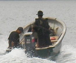
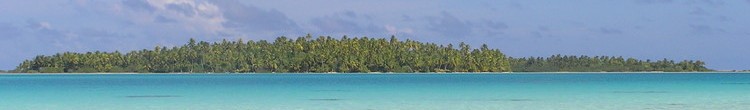
We left Isla Canal Afuera, for Bahia Damas, Coiba. After a 4 hour sail we reached Bahia Damas and anchored on sand between two sections of reef, one of which is rumored to be the largest coral growth in the eastern Pacific. After about an hour we heard a whistle and came up on deck. There were three military police all carrying sub-machine guns slung around their necks. After an awkward exchange in broken Spanish they politely told us we must leave and check in with the park. I told them it was too far to go before dark but they insisted. So we pulled up the anchor and headed for the Park Station over two hours away.
After we were underway they came back and asked politely for our passport numbers. Officially we have "checked out" of Panama and have exit stamps on our passports and an international zarpe (clearance) for Costa Rica. The Port Captain in Panama City said we could make stops and wrote Las Perlas on our zarpe but he did not go as far as to include Coiba. So on paper we are not supposed to be here. Without hesitation I handed over our passports. They wrote the numbers down and politely gave them back to us. Then they assured us the Park Station was not far away and left.
Now what do we do? We could just head for Costa Rica 130 miles away without any consequences as we have all of our paperwork in order. If we stay there is a risk that immigration would have a problem with us stopping here. As we motored towards the park station we discussed our options. Frankly, all of my dealings with officials in Panama have been very straight forward and they are always polite. In fact my best check out ever was this last time in Panama City where the actual Chief Port Captain came outside his office when I was finished and called me a cab back to the boat. Perhaps the Port Captain of Salvador, Brazil should take some notes!
We motored faster than usual, as we just had barely enough time to make the park station by night fall. As we motored up the coast, I noticed that the GPS datum for the chart we were using was severely off and had us sailing through some of the small islands off the coast of Coiba. Frankly, this is not unusual in some parts of the world. Perhaps the datum was never updated, as part of the worlds conversion to satellite position fixes. The only problem in this situation is that you need visibility to navigate close to shore. For this approach we definitely needed visibility because there are several rocks to avoid and no direct approach.
Unfortunately, we could see a heavy squall looming over the mountains near the bay where the Park Station is. It started raining and then the wind kicked up and veered to the north which would make the anchorage off the Park Station untenable. Soon the visibility was down to nothing and we were using radar, set to the 1/4 mile range, to feel our way forward. We were less than 2 miles from the park station but it was just to risky and we had turn around.
I told Andrew to prepare himself for a night at sea as I planned to sail out to deep water in the lee of Coiba and heave to (idle the boat in to the wind) for the night. We would run our 3 hour watches and then sort ourselves out in the morning. Fortunately, on the way out to deep water we passed close enough to Isla Rancheria to see a possible anchorage at the southern side of the island. South facing anchorages in Panama this time of year can be dangerous as a large swell from the south can arrive without warning. However this anchorage looked okay and it was very protected from our current north westerly wind. We anchored in 30 feet of water, which is deeper than I would have normally tried for in bay like this, but I did not want to wake to large breaking waves too close to shore.
We are a little nervous that the police might construe us anchoring here as an attempt to evade the park authorities, as Isla Rancheria is still part of Coiba National Park. On the radio we heard Isla Rancheria calling the National Park and we thought we were going to be in trouble but no one has come for us. Andrew is clearly shaken by the days events and opted for an easier tortilla, rice, and bean dinner over Polynesian "Pousin Cru" with fresh yellow fin tuna which is out of character for him. I am tired too so did not push the latter.
The anchorage is pretty rolly but not overly uncomfortable. At first light, we will go to the park station and hopefully get permission to visit the park.
Comments
| Vessel Name: | Cisnecito |
| Vessel Make/Model: | Swan 46 MkII |
| Hailing Port: | Newport, RI |
| Crew: | Julie and Chris Mays |
| Extra: | After three years of freezing in New York, we decided to give up our corporate careers to set sail on the opportunity of a lifetime... |
| Home Page: | http://www.cisnecito.com/ |
Gallery not available
Who: Julie and Chris Mays
Port: Newport, RI
Updates
Favorites
- Ashby's Boatyard - Opua, New Zealand
- Bali Hai, Moorea
- Freefall - Axel and Emma
- Gypsy Soul - Ben
- Hacienda Merida, Nicaragua
- Indigo Bay, Mozambique
- La Familia - Teresa and Yngve
- Land and Sea Marina, Costa Rica
- My Cousin Andrew's Blog
- Northern Star - Anne and Mogens
- Opua Marina, New Zealand
- Out of Bounds (Cisnecito�s first trip around)
- Pamina - Connor & Henri
- Peake Boat Yard, Trinidad
- Performance Yacht
- Petrel - Marit and Frode
- Quetzal Trekkers, Nicaragua
- Royal Cape Town Yacht Club, South Africa
- Semonkong Lodge Lestho
- Zululand Yacht Club, Richard's Bay, South Africa