Jonathan Crinion Ocean Racing
Jonathan Crinion and one of the world's leading Naval Architecture firms; that of Owen Clark Design LLP have together designed and developed a superb racing machine to the new Class 40 Rule of 2004.
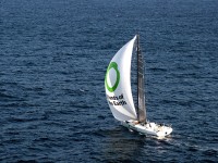
| Vessel Name: | Friends of the Earth |
| Vessel Make/Model: | Owen Clark Design Open 40 |
| Crew: | Jonathan Crinion |
20 October 2006 | Pendennis Marina, Falmouth, UK
Falmouth
Well that's it, Cape Town to Falmouth. This last bit of the voyage from Madeira has seen some of the worst weather ever - non stop. My wind strategy worked well to go up the centre of the English channel and ships criss crossed all night. The weather grib files have been hopelessly wrong for the past [...]
18 October 2006 | 48,5.57N , 9,13.81W
Knock down
The ocean can be brutal. More to the point the weather can be. Yesterday was sunny but with large swells and I had been hitting 17 knots reaching on and off for most of the afternoon. Speeding off faster and faster, the feeling is exhilarating. With a reef in the main and the Genoa up I was under canvassed [...]
17 October 2006 | 45,29.51N , 11,19.44W
Approaching the channel
All along I've used one nautical chart for the Southern Hemisphere and St Helena and another for the Northern Hemisphere plus one for Madeira. I'm making fast progress at the moment and should be on the 10 degree West Longitude line shortly where I will switch to a detailed chart to take me into La [...]
17 October 2006 | 42,44.86N , 13,40.48W
Contemplation
I'm starting to understand why Bernard Moitessier made the turn and headed towards the Pacific. He was wondering what he would arrive back to if he kept going on to the UK. It's so vast out here and so far away from everything. I have a 360 degree view of the universe. I'm completely self sufficient [...]
16 October 2006 | 42,33.68N , 14,3.52W
Storm Warning
Wisdom says go wide of the Bay of Biscay but my weather files are showing a huge area of no wind to the West of me which forms the centre of a large and very vicious looking low heading this way.
Heading North for Rest and Repairs
Speed: 7 knots, Course: 347 deg.
UTC Time: 04. August 2006 09:49
We tacked West to get better winds further out and not so much directly on the nose. This new starboard tack took us directly to the Cape Verde Islands and we passed between Ilha da Boavista and Ilha do Maio in the dark at about 5 this morning.
Its 9:50 now and we are heading almost directly North with Ilha do Sal to our right (starboard). There is a noticeable difference in the weather already as the sky is clear and its warm and sunny. Also the flying fish are huge in comparison to the other ones up until now.
We have sailed 4452 nautical miles now, that's about 8248 km. It's not surprising over that distance and with the brutal weather that things have broken and worn out.
We are heading to a small marina called Quinta do Lorde on the Eastern tip of the Madera Island to make repairs. It's the only marina with water deep enough for our 3 meter draft (Depth from the water line to the bottom of the keel)
It's about ten days away now if the wind holds. It's nice to dry things out and skim along on reasonably flat water. I feel a big nap coming on now.
All the best,
Jonathan