Cruising with Grace
Who: Alex Cullen
Port: Needham MA
20 May 2018 | My kitchen, Needham MA
16 May 2018 | Mooring 831, Hewitts Cove, Hingham MA
04 May 2018 | Cape May harbor, off the Coast Guard base
25 April 2018 | Onancock Creek
10 April 2018 | Barefoot Landing Marina, which is free while they are closed
02 April 2018 | Turtle Island, just inside the border with South Carolina
26 March 2018 | St Augustine Municipal Marina, right next to the Bridge of Lions
22 March 2018 | ICW Mile 946
17 March 2018 | Old Bahama Marina, West End, Bahamas
11 March 2018 | Conch Marina, Marsh Harbor
04 March 2018 | Anchored off Russell Island next to Spanish Wells
24 February 2018 | Off Monument Beach, Stocking Island
18 February 2018 | Anchored off Stocking Island, across the harbor from Georgetown
11 February 2018 | Georgetown
04 February 2018 | Nassau Harbor Club Marina
28 January 2018 | In a slip at the Nassau Harbor Club Marina
19 January 2018 | Anchorage between Whale and Bird Cay
15 January 2018 | South of Frazier Hog Island
11 January 2018 | Browns Marina, Bimini, Bahamas
07 January 2018 | No Name Harbor, Key Biscayne
Crossing the Great Bahama Bank
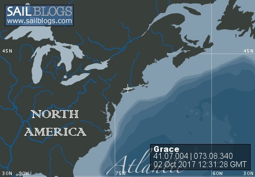
15 January 2018 | South of Frazier Hog Island
Scattered clouds, 74, 15 kt winds from the north.
If you look at a map of the Bahamas, you'll see that it consists of groups of islands separated by great distances. Sometimes these groups are separated by deep water, like the Northwest Providence Channel, which is over 8000' feet deep. Other times they are separated by shallow - 8-20' deep, banks. The Great Bahama Bank is the largest of these - stretching from Bimini on the west to Andros and the Berry Islands on the east, and going hundreds of miles south. The Bimini islands and the islands south of Bimini mark the very edge of the Great Bahama Bank - if you go a mile west of Bimini (towards Florida), the water is already over a thousand feet deep.
Faith Afloat - my buddy boat, and I left Bimini on Friday morning. We had two restful days in Alice Town on Bimini, with swimming, couch salad, and shopping for food when the supply boat came in (the grocery stores are pretty bare before the supply boat comes in, and after, they are chock-a-block full of vegetables, fruit, meat, etc). I made french toast Thursday morning with the bahamian bread.
Our destination on Friday was Honeymoon Cove on Gun Cay, south of Bimini. We had a great sail in 10-15 kt south winds and 2-3' seas. However, as we tacked back and forth, we found we were making little progress towards our destination. The culprit - the gulf stream, which comes within a mile of the islands. When we sailed on a close reach southwest, the chartplotter would show our actual course bending towards the east - and the converse as we tacked back towards the islands. After four hours of this, we cranked up the 'iron genny' - our engines.
Honeymoon cove is a very nice cove for anchoring and swimming - except when the wind and seas are from the south. As we felt our way in through the sand banks, we could see waves crashing on the beach and one lone sailboat at anchor pitching back and forth. Clearly, this was the wrong day for Honeymoon Cove. So we motored west into the banks, then south to Cat Cay.
Cat Cay is the island equivalent of a private gated community. The community is the Cat Cay Yacht Club - and when you go ashore, one of the first things you see is a board saying which club members were on the island. This is a word away from seedy, but authentic, Alice Town. We anchored off Cat Cay and I a swim around the boat, followed by a lovely pasta dinner on Faith Afloat.
The next day we started out early across the Great Bahama Bank, with north winds 10-15 kts. The water - 8-15' deep, was a pale emerald color. Our destination was the Berry Islands - 80 miles away. This meant we'd need to spend a night anchored out somewhere in the middle of the bank.
Now this whole cruise, from Hingham to where I am now, is an adventure - and adventures aren't always fun. Anchoring out in the bank when the winds are light and the skies clear can be a wonderful adventure, with nothing between you and the stars. Unfortunately, the sky clouded up, the winds strengthened to over 20 kt and the seas built to 3+ feet. You've heard of the 3 axis of motion - Grace went through all of them all night long: pitching (front to back), rolling (side to side) and yawing (turning left and right). It was hard to move, and of course hard to cook. Sleeping was OK, except for the sound of the waves against the hull and the sounds Grace would make as she rocked back and forth.
Yesterday we rose to grey skies and rough seas. The wind strengthened to 20+ kts, and the seas to 4'. Faith Afloat and Grace motored the rest of the way across the bank, into the Northwest Providence Channel to the Berry Islands. This was actually a more grueling run than across the gulf stream!
Presently I am anchored in 12' of water on the south side of Frazier Hog Island. While it is still windy, we are somewhat sheltered from it and the sea is 'relatively' calm. The water is a deep emerald color. The island itself is not very attractive - all austrialian pines, and the beachs are smooth limestone, not sand. We'll be here for two days, and then move up the Berry Islands chain to find more attractive places to stay. I plan to be here in the Berrys until next Wednesday.
Note to readers: Because of the spotty - and costly, cell phone coverage, blog updates will be somewhat less frequent. Updates to the photo gallery will wait for when I'm ashore and can get WiFi. Sorry!
Comments
| Vessel Name: | Grace |
| Vessel Make/Model: | Catalina 320 |
| Hailing Port: | Needham MA |
| Crew: | Alex Cullen |
| Extra: | This trip will be my 'transition to retirement' |
Grace's Photos - Main
 |
|
|
46 Photos
Created 14 November 2017
|
|
Who: Alex Cullen
Port: Needham MA