
Foggy Mountain
05 September 2012 | North Palm Beach, FL
12 June 2012 | North Palm Beach Marine
18 May 2012 | Exiting NW Providence Channel
17 May 2012 | NE Providence Channel
16 May 2012 | 88 Miles East of NE Providence Channel
15 May 2012 | 210 Miles East of NE Providence Channel
14 May 2012 | 170 Miles NE of Mayaguana Island
13 May 2012 | 180 Miles NE of Turks and Caicos
12 May 2012 | Still North of Puerto Rico
11 May 2012 | 170 Miles North of Puerto Rico
10 May 2012 | 50 Miles NE of the BVIs
09 May 2012 | 25 Miles West of Barbuda
08 May 2012 | Falmouth Harbour, Antigua
07 May 2012 | Falmouth Harbour, Antigua
05 May 2012 | Falmouth Harbour, Antigua
05 May 2012 | Falmouth Harbour, Antigua
11 April 2012 | Falmouth Harbour, Antigua
09 April 2012 | Falmouth Harbour, Antigua
08 April 2012 | Falmouth Harbour, Antigua
07 April 2012 | Falmouth Harbour, Antigua
Close Call During Last Night at Sea and We Made It- Yahoo!!!
15 February 2011 | Jolly Harbor, Antigua
Jeff
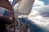
First the previous day's stats. Our run from yesterday at noon to our arrival time here in Antigua at 0830 was 100 miles, total for the trip was 1571.02 nautical miles in 12 days 23 hours which works out to an average speed of 5.05 knots. This is the slowest average speed for a passage that we have ever had but it is also the first passage where more than 90% of our time has been spent beating. And, guess what point of sail we were on for most of the day yesterday. Yup, for those of you that have been following our passage you know we were beating again. The predicted wind direction was ESE and actually was closer to SE. We were basically trying to hold a course just slightly east of directly south. So we started out yesterday sailing as close to the wind as we could but, with the 6 to 8 foot swell we were only able to hold a course just west of south hoping that eventually the wind would back to the ESE later in the day. As the day went on the wind toyed with us occasionally backing to the ESE only to return to the SE. However, the further south we got the toying stopped and the wind finally backed to the ESE. But because we had lost easting for the earlier part of the day we had to sail close hauled again to gain back our easting. With our concerted effort last night we managed to crawl our way back upwind far enough so that we could relax a little. Another good thing was that once we got in the lee of Barbuda (Pam called it Big Buda), the island just north of Antigua, the seas flattened out because Barbuda was blocking them for us. We also had no squalls last night, which was welcome relief from the previous nights adventure. One final number to wrap up, after her 15th flying fish kill Foggy Mountain never victimized another one during this passage.
Last night was not without its drama though. Pam woke me up with the comment that we had red lights flashing on the AIS system and she wondered if I would check it out because she was watching a possible squall cloud. So I pulled out the iPad to check it out. There was some initial concern because the iPad displayed a ship with a coordinates very close to us but the iPad's GPS hadn't located us yet so it wouldn't display the closest point of approach information that is so vital in these situations. All I knew was that the ship was off our port side and not very far away. Pam looked in that direction but initially didn't see anything. Probably due to a squall between us and the ship reducing both of our visibilities. Then suddenly and fortunately the iPad's GPS located us and my concern further elevated. We were on a collision course with this 700 and some foot tanker headed for St. Croix in the US Virgin Islands. So I got on the VHF and called the ship by name asking them if they could see us and that my AIS indicated that our crossing distance was going to be less than a half a mile. They responded immediately saying that they could see us and that they were going to alter course to widen that crossing distance. Collision averted, thank you again AIS.
Our final morning at see was sailing close hauled, what else a surprise, in basically ideal conditions - 10 to 12 knots of wind with a one to two foot chop and no swell. We beat up into the entrance of the channel to Jolly harbor, doused the sails and went in to clear Customs. After tying ourselves up at the Customs dock, no one available to help us we had a pretty uneventful almost enjoyable clearing in process. Everyone was very friendly and the process took about an hour. After clearing in we called Jolly Harbor Marina for a slip. We decided to pull into the marina so we could wash down Foggy's salt caked decks and to attend to some problems that have cropped up during this punishing passage. Primarily we want to attend to a leak in our port side deck before we do any more sailing and we figure we can better do it here at a marina where we should be able to procure everything we need to fix it. Of course we won't know that for sure until we tear apart the overhead of the cabin in the area where we found the water. But we won't tackle that tomorrow because it is Pam's birthday. And our friends here on the island have invited us to their house for the night. We have taken the slip for a week so hopefully we can get all of our projects done in that time frame. Wish us luck, I'm going to bed now.
Comments
| Vessel Name: | Foggy Mountain |
| Vessel Make/Model: | Valiant 40, Hull# 255 |
| Hailing Port: | Boston, Ma |
| Crew: | Jeff & Pam Nelson |
| About: | |
| Extra: |
Gallery not available
Our Background
Who: Jeff & Pam Nelson
Port: Boston, Ma