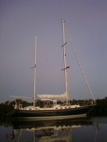
S.V. Gratitude
Brewer 44, hull number 284
18 March 2019 | Cumberland Island, GA
08 February 2019
08 February 2019 | George Town, Exumas
01 February 2019 | Great Harbor Cay
31 December 2018 | Stuart, FL
21 December 2018 | Stuart Florida
21 December 2018
17 December 2018 | Stuart, FL
14 December 2018 | St. Augustine, FL
13 December 2018 | Sister’s Creek
12 December 2018 | Atlantic Ocean
11 December 2018 | Windmill Harbour
01 March 2017 | Exumas
26 February 2017 | Jumentos Cays & Ragged Islands
09 February 2017 | Hog Cay, Jumentos Islands, Bahamas
27 January 2017 | En Route to Nassau
23 January 2017 | Sister Creek, Marathon, FL
06 January 2017 | Cayo Costa State Park
17 March 2016
14 March 2016
Lauren's Birthday
13 February 2011 | Emerald Bay Marina, Exumas
EVS: Stormy
February 13, 2011: Lauren’s Birthday
Happy Birthday to the 29 year-old (again)! We now are at the Marina at Emerald Bay, having come here from Lee Stocking Island (a) to avoid a frontal passage (more below) and (b) to check out the place as a possible location to pick up and disembark passengers. The front came through and the winds clocked to the NE, from whence they cometh now. Unfortunately, our stern is to the NE (and sailboats – all boats – are happier with theirs bows to the wind). As a result, we spent (and are continuing) an uncomfortable ride at the dock. We have multiple lines out so we (as well as the other boats) look like we are trapped in a spider’s web. However, lines stretch so no matter how tightly we try to contain the boat (and these are floating docks, so that can be done), the lines stretch, Gratitude moves, and soon becomes a lurching beast only to be stopped in her tracks by a line or series of lines stretched taut and then brought back to do it all over again. One line has worn a groove in a teak toerail – the line is at an angle and misses the stainless tell protector. Definitely will have to varnish now. The winds are not that high (15-20+), but they are making us move. Being at anchor is a lot more comfortable; the boat is free to move about, the anchor is fitted with a snubber-line and an elastic shock absorber, so there is none of this “moving boat comes against immovable object and stops” routine. NEXT time, we shall ask for a slip that faces into the predicted winds, or we will stay on the hook somewhere.
After visiting Little Farmer’s Cay, we motored (yes, we do a lot of that – the winds were right in our teeth and very light) down the outside (i.e. in the Exuma Sound aka ocean) to approach Lee Stocking Island. We left Sanity II behind (departing at about 8:00 am along with First Draft). We waved and said our farewells, and then headed outside. The cut was calm and quite comfortable, and there was a gentle swell outside, but light winds. We approached Lee Stocking from the north end and were advised by First Draft that there was one mooring free. We thought that meant they had taken one, and so were surprised to see them coming back out of the mooring field as we entered. They had tried to pick up the mooring but decided to anchor out. We soon understood why – the mooring balls have very short tethers and no pick up lines so it was impossible to pick the ball out of the water to tie to it. Van got the boathook into the eye (not knowing) and had the boathook pulled from his hands. We watched it float off and tried again, this time planning to reach down to the loop with a line. Unfortunately, each time we stopped (upwind of the ball to block the wind and waves), Gratitude slid down over it, pressing the ball down and out of reach. After the third try, folks from another boat came over in their dinghy and took our line to pass through the mooring loop and back up. Had that not happened, we would have dropped the anchor (which we did the next day anyway).
Lee Stocking Island is the home of the Perry Institute of Marine Science. PIMS studies the marine ecosystem, with an eye on eradicating invasive species (e.g. Lionfish, a dangerous spiny fish that also happens to be quite edible – if one waits 30 minutes, or was it an hour?, after the fish is removed from the water) and the impact of various diseases on coral. It is the slow season, so none of the scientists were there nor were there any real exhibits to see. The young woman who gives tours (Tuesdays and Fridays) is the public relations person, has been there 4 years, and really did not have answers to a lot of questions. In all, what could have been very interesting and informative, left a lot to be desired. But, the scenery more than made up for it. We hiked to the top of Perry’s Peak, at about 40’, the highest point in the Exumas, and were rewarded with a fabulous view of both the Bank and Sound side as well as many of the Cays we had been to (north) and some we are approaching (south). We dinghied to the west side of Norman’s Pond Cay, so named, evidently, for the now abandoned salt pond on the interior. (The natives/settlers would allow the ponds to flood repeatedly and then dig the salt out of the containment areas, that looked much like rice paddies.) It took some time, but we finally found the entrance to the pond. The bar was too shallow to motor in, so we poled through the entrance and a small forest of mangroves. A lot of juvenile fish darted about – it is easy to see how mangroves are such prolific breeding grounds. We did not go far to the interior fearing we would get the dinghy stuck in the receding waters, but we could see some of the embankments and marveled at the hard work involved.
From there, we dinghied to Tug and Barge Rocks (from a distance, that is exactly what they look like) to snorkel, but it was too windy and rough, so we headed back to Gratitude for the afternoon.
While at Lee Stocking, we saw a motor yacht named Quest, with the “Q” font looking vaguely familiar. Her owners, Dan and Judy, dinghied by, saw our VT home port, and announced they live in Middletown Springs, about 45 minutes south of us. They own a construction company that does a lot of work for various clients. They bought Quest in Oregon, had her refitted with new electronics (she is a 1983 Hatteras) and then left there in January 2009, traveling down the West Coast, through the Panama Canal, up the east coast, the Hudson River and through Lake Champlain, from which they turned west through Lake Michigan and then down the Mississippi, Ohio, and Kentucky Rivers (one of the so-called Great Loop options), and now are in the Bahamas. What a trip!
Because a storm front is coming (thank you, Billy Joel!), we decided to head further south to check out Emerald Bay Marina, just north of Georgetown. We had heard it is well protected and offers an option to receive and disembark guests flying to and from Georgetown. We had a lovely, calm ride down and came into the marina, refueled, and took our assigned slip. Unfortunately, as noted above, it is stern to the wind, and rocky/rolly.
This morning, being Sunday, we walked to the nearest (or so we were told – it was about 4 miles with missed turns) church. We actually had a choice between two. We asked the difference and were told one “would want you to stay longer” so we chose the other. As it was, it lasted 1¾ hours! A lot of singing, praise Gods!, halleluiahs, and VERY loud. (Dave A., your mother would have been very proud of me!) One of the parishioners and her English husband gave us a lift back and offered to assist in anything we might need. Typically warm and gracious folks in these parts.
Tonight, dinner out (birthday and Valentines Day). After church this morning, Van will have earned his brownie points!
Comments
| Vessel Name: | Gratitude |
| Vessel Make/Model: | Brewer 44 Ketch |
| Hailing Port: | Brandon, VT |
| Crew: | Van and Lauren |
| About: | It is hard to believe, but this is our 7th season aboard Gratitude. It will be a short season and close to FL, but we hope to relax, enjoy the time, being on the water, and each other. Come along. |
| Extra: | Live it while you can. |
Gallery not available
2015 Cruise
Who: Van and Lauren
Port: Brandon, VT