
SV Irish Melody
12 November 2017 | Vuda Marina Fiji
26 June 2014 | 17 14.963'S:176 50.086'E, South of the Yasawas
23 June 2014 | 13 40.036'S:177 51.919'E, South of Rotuma
16 June 2014 | 08 31.477'S:179 11.432'E, Funafuti Atoll, Tuvalu
11 June 2014 | 06 21.740'S:177 10.005'E, West of Niutao
08 June 2014 | 04 34.534'S:175 20.080'E, North of Nanumea
04 June 2014 | 02 27.040'S:174 17.216'E, West of Tamana and Arorae, Southern Kiribati Group
01 June 2014 | 01 00.577'S:173 34.626'E, West of Nonouti, Southern Kiribati Group
30 May 2014 | 01 21.334'N:173 01.965'E, Parliament House, Ambo, Tarawa, Kiribati
23 May 2014 | 01 21.334'N:173 01.965'E, Parliament House, Ambo, Tarawa, Kiribati
18 May 2014 | 01 21.334'N:173 01.965'E, Parliament House, Ambo, Tarawa, Kiribati
05 May 2014 | 07 06.486'N:171 22.050'E, Republic of the Marshall Islands (RMI)
06 January 2014 | 07 06.486'N:171 22.050'E, Majuro - Marshall Islands
03 January 2014 | 05 38.276'N:171 38.759'E, South of Mili Atoll - Marshall Islands
29 December 2013 | 01 21.338'N:173 01.958'E, Ambo �- Parliament House �- Tarawa Lagoon.
23 December 2013 | Ambo, Tarawa Lagoon
13 January 2013 | off Ambo Village - Tarawa Lagoon
29 December 2012 | Near Banreaba - Parliament House - Tarawa Lagoon
21 December 2012 | 01 21.925'N:172 55.772'E, Betio Harbour, Tarawa, Kiribati
20 December 2012 | Southwest of Tarawa, Kiribati
Angsty Anchoring…
21 October 2011 | Hitu-Lama - Pulau Ambon
Andy
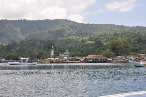
We had planned to arrive at Hitu-Lama – Pulau Ambon in the early morning after an overnight sail from Buru. When the wind died around midnight, it merely meant a later morning arrival. Motoring (again!) towards the bay, we picked out the mosque (nearly always mentioned as the most visible landmark in the sailing directions for these waters) and eased our way into the busy harbour. It seemed cluttered with fishing boats and empty moorings, after the isolation of the previous small kampongs and bays. People crowded the wharf, minding their own business, but to us it felt like another public performance anchorage. Our GPS, never to be totally relied on, already had us travelling overland, even though it had helped us pick out the rough location of the three reefs to be avoided in the bay. The electronic MaxSea charts with satellite overlay provided extra collaboration to the skimpy information on the paper chart.
Luckily the sun came out from the clouds and shallow water visibility improved. As we eased slowly in and around the nets of a boat trawling just off the main wharf (!!) and the other moored boats, several men shouted out to us. Tony thought they were just saying hello, I thought they were saying turn around, you are about to hit the reef. Long story short, it took over an hour to painstakingly circle our way into an eventual 15 metre anchorage, with the reef and light blue shallow water clearly visible what seems like mere inches away. The seabeds rise so sharply at many Indonesian islands, that one minute you are in 60 metres of water (who carries that much chain!), the next – no water left at all, drying reef. It won’t be such a restful night tonight as we listen carefully for the slightest sound of anchor drag!
The bonus is that Hitu-Lima, with its proximity to Ambon city, has the best internet connection we have struck since leaving Ternate. (Still only dial up speeds, but doesn’t keep dropping out.) We now know who’s in the final for the World Cup! And, the more sobering news about Colonel Gaddafi.
Comments
| Vessel Name: | Irish Melody |
| Vessel Make/Model: | C&C Landfall 38 |
| Hailing Port: | Brisbane (formerly Santa Rosa) |
| Crew: | Anthony (Tony) and Andrea Mitchell |
| About: | Decided to act on our mid-life crisis and take a gap year....so 2012-13 will see us heading out into the Pacific via Thursday Island and the Solomon Islands. |
Gallery not available
SV Irish Melody
Who: Anthony (Tony) and Andrea Mitchell
Port: Brisbane (formerly Santa Rosa)
Favorite Links
No Links Added Yet