
Jascat to the Bahamas
21 October 2014 | Docked along the St Lucie River in Stuart, Fl
13 October 2014 | Docked along the St Lucie Canal Between the Bridges
12 October 2014 | Anchored in the Manatee Pocket, Stuart, Fl
08 October 2014 | Anchored Between the Bridges
07 October 2014 | Anchored in Ding Darling
06 October 2014 | Pelican Bay
03 October 2014 | Charlotte Harbor Boat Storage
09 June 2014 | Sitting on the blocks in Charlotte Harbor Boat Storage
07 June 2014 | Anchored off Cattle Dock Point
05 June 2014 | Anchored just off the Ding Darling Park on Sanibel Island
02 June 2014 | Anchored near marker #7 in the Indian River
31 May 2014 | Anchored off Long Key just south of Fiesta Key
29 May 2014 | Tied to dock at Dinner Key Marina
28 May 2014 | Tied to dock at Pier 3, slip 3
20 May 2014 | Tied to dock at Dinner Key Marina
12 May 2014 | Tied to mooring ball in the Dinner Key Mooring Field
07 May 2014 | Nassau Harbor Club Marina
06 May 2014 | Tied to dock at Nassau Harbor Club Marina
02 May 2014 | Anchored off Black Point, Great Guana Cay
29 April 2014 | Anchored west of Big Majors Spot
Nassau to Coconut Grove
12 May 2014 | Tied to mooring ball in the Dinner Key Mooring Field
John
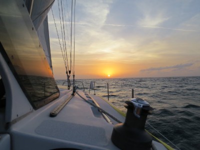
Sunset on the Great Bahama Bank about 60nm east of Cat Cay
We are back in the good old USA, Coconut Grove to be specific. After dithering for three days in Nassau over less than ideal weather forecasts, we finally decided that we needed to go or we could get stuck in Nassau indefinitely. The weather guru was saying that a low was potentially going to move into the Bahamas in four or five days possibly spawning storms and generally nasty weather for an extended period of time.
As we sat looking at the weather on Friday (the 9th), the forecast for Saturday through Monday indicated east winds from 10 to 20 kts all the way from Nassau to Miami, 4 to 6 foot waves in the ocean at Nassau, and 2 to 4 foot waves in the Gulf Stream with the occasional five footer. The Tuesday forecast was the same for Nassau but showed 3 to 5 foot waves in the Gulf Stream. After that the low was predicted to come in with thundershowers and rain for the next several days.
The first problem with the forecast was that it only gave us three days to reach Miami before the low set in. We had originally intended to do a leisurely four day sail stopping for the night at Chub Cay, the middle of the Bahama Bank and Cat Cay. So the first decision was that we would eliminate the stops and sail straight through to Miami.
From there, we only needed to convince ourselves that the forecasts for Saturday and Sunday were acceptable. The wind direction and speed was ideal for a fast downwind sail. The problem with the forecast was the predicted six foot wave height in the ocean around Nassau. Our comfort limit on wave height is three feet going into the waves and four feet if the waves are following.
Our decision to go was based on the wind direction. The wind had been out of the east for several days and was forecast to stay that way until the low came in. That meant that the seas would be on our stern the entire way to Miami if we left on Saturday. Six foot trailing seas pitch the boat about uncomfortably but aren't dangerous. It just gets hard to move about and do simple things like make a sandwich or take a nap. Moreover, even if the waves were that large, we would only be in them for the first eight hours of the trip. Forty nautical miles east out of Nassau, you pass out of the Tongue of the Ocean with its two mile depths to the Great Bahama Bank which is less than 20 feet deep. These shallow waters can't sustain six foot waves, at least in winds less than 20 knots.
So, with some trepidation we left the Nassau Harbor Club Marina at 8am Saturday morning. Our worries were dispelled somewhat when a cruiser friend, who had left a half hour before, radioed us as we were leaving the harbor that the seas out in the ocean were only two to three feet. Later in the day, the waves got up to the four to five foot area for a couple of hours but were comfortably widely spaced. As we expected, the waves lessened as we passed on to the Great Bahama Bank making for a very comfortable fast, night sail. Especially comforting was a near full moon that was with us until about 4am.
The run across the Bank was in fact too fast. We had averaged around six knots crossing the Tongue of the Ocean which went up to the 6.5 knot range on the Banks. This threatened to get us to Cat Cay well before dawn which was a problem. Our path off the Great Bahama Bank and out into the Straits of Florida passed through a narrow, rocky cut between Gun Cay and Cat Cay which we didn't want to take in the dark. We hadn't been there before and were not sure of the accuracy of our charts or GPS.
One option for killing time was to "heave- to" which is cross rigging the sails and rudder so that the boat makes minimal or no forward speed. Jascat doesn't do this maneuver well so that was out. Another option was to anchor for a couple of hours. The three foot seas were comfortable enough sailing downwind but wouldn't have been so pleasant sitting at anchor. So, around midnight, the option we ended up with was to drop the main sail and pull in the jib so that just a small patch was showing. This slowed us down to the 3.5 knot range which allowed us to pass through the Cat Cay/Gun Cay Channel just after dawn.
Except for dodging freighters, the Gulf Stream Crossing also turned out to be quite pleasant. We did see four foot waves but they were on our beam or stern and were widely spaced. We did have to maneuver to avoid two freighters. Before the AIS system, the fast current of the Gulf Stream made judging whether you were on a collision course with a freighter very difficult. The up to 4 knot current in the Gulf Stream causes the actual path of the sailboat, which may only be doing 5 knots straight ahead, to be moving nearly as much sideways as forward. Thus, the view straight over the bow isn't necessarily where the boat is going. Ann and I made our first crossing of the Gulf Stream at night back before AIS. Trying to judge the relative paths of ourselves and the freighters was frightening. Especially since the only thing we could see of the freighters were their lights.
All that has changed with AIS. This system plots the true courses of both yourself and the large ships in the immediate area on the chart plotter which makes deciding whether to take avoiding action relatively easy. Freighters, by the way, are always assumed to be the "stand on vessel" (i.e., they aren't going to change their course for anybody that weights less than they do).
To summarize, we left Nassau at 8am, Saturday and arrived at Government Cut in Miami at 3pm, Sunday for a fun, fast 31 hour sail. Of that, we were under sail for about 28 hours. The wind died out on us as we were passing through the apex of the Gulf Stream forcing us to motor for about three hours to Miami. Passing through Government Cut (which is where the cruise ships dock), we motored on for just over an hour to the Dinner Key Mooring Field off Coconut Grove where we took up a mooring a little after 5pm. The next day we rented a car and drove over to the Department of Homeland Security at the cruise ship docks to check back in to the US and the Bahamas part of our trip was officially over.
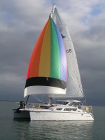
| Vessel Name: | Jascat |
| Vessel Make/Model: | Gemini 105Mc (hull #1006) |
| Hailing Port: | San Antonio, Texas |
| Crew: | John and Ann Barton (and Sarah, part time) |
| About: | |
| Extra: |
Gallery not available
Who: John and Ann Barton (and Sarah, part time)
Port: San Antonio, Texas