
Passion for nature
Palawan, My land
12 July 2009 | Palawan, Philippines
JoeyR
Palawan
Palawan is an island province of the Philippines located in the MIMAROPA region. Its capital is Puerto Princesa City, and it is the largest province in the country in terms of total area of jurisdiction. The islands of Palawan stretch from Mindoro in the northeast to Borneo in the southwest. It lies between the South China Sea and the Sulu Sea. The province is named after its largest island, Palawan Island, measuring 450 kilometers (280 mi) long, and 50 kilometers (31 mi) wide.
Palawan is composed of the long and narrow Palawan Island, plus a number of other smaller islands surrounding the main island. The Calamianes Group of Islands, to the northwest consists of Busuanga Island, Culion Island, and Coron Island. Durangan Island almost touches the westernmost part of Palawan Island, while Balabac Island is located off the southern tip, separated from Borneo by the Balabac Strait. In addition, Palawan covers the Cuyo Islands in the
Sulu Sea. The disputed Spratly Islands, located a few hundred kilometers to the west is considered part of Palawan by the Philippines, and is locally called the Kalayaan Group of Islands.
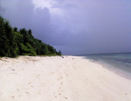
Palawan's almost 2,000 kilometers (1,200 mi) of irregular coastline are dotted with 1,780 islands and islets, rocky coves, and sugar-white sandy beaches. It also harbors a vast stretch of virgin forests that carpet its chain of mountain ranges. The mountain heights average 3,500 feet (1,100 m) in altitude, with the
highest peak rising to 6,843 feet (2,086 m) at Mount Matalingahan. The vast mountain areas are the source of valuable timber. The terrain is a mix of coastal plain, craggy foothills, valley deltas, and heavy forest interspersed with riverine arteries that serve as irrigation.
The history of Palawan may be traced back 22,000 years ago, as confirmed by the discovery of bone fragments of the Tabon Man in the municipality of Quezon. Although the origin of the cave dwellers is not yet established, anthropologists believe they came from Borneo. Known as the Cradle of Philippine Civilization, the Tabon Caves consist of a series of chambers where scholars and anthropologists discovered the remains of the Tabon Man along with his tools and a number of artifacts.
Geography focus on Bataraza (Rio Tuba)
Bataraza is located on the southernmost tip of mainland Palawan, approximately 236 km from Puerto Princesa City and about five to six hours by land. It has total land area of 957 km². Bataraza is situated some 775 km (480 mi) southwest of Manila. It stretches approximately 80 km in northeasterly to southwesterly direction between roughly 8.3 and 8.75 degrees latitude north of the equator.
Bataraza lies amidst the south Sulu Sea Malis River rounded at Cape Buliluyan and further extended up to Wangly River in the south western part of the mainland. It is bounded in the east by the Sulu Sea, in the west by a great mountain range, extending from Mount Mantalingahan (the highest peak in the province) to Mount Malitub, which serves as the divider between Bataraza and Rizal, and in the southwest by the South China Sea.
Rio Tuba is one of the populated barangays in the Municipality of Bataraza in the Province of Palawan in the Philippines. It is about 236 kilometers from Puerto Princesa City, the provincial capital. The town of Bataraza can be reached by bus, jeepney, or shuttle van which departs daily from the city. Bataraza is about 6 hours drive from Puerto Princesa City.
Name:
The name "Rio" is a Spanish term which means river. However "Tuba" is a local plant which was used by the natives a poisons to fishes during their local festivities.
Sitios:
* Bukid-Bukid
* Santo Niño
* Marabahay
* Tagdalungon
* Bungkol-Bungkol
* Macadam
* Racob
* Kinurong
* RTN Townsite
* BCI
Transportation: (early years)
It is also in Rio Tuba where means of transport are available to reach most of the inner barangays of Bataraza either by public utility jeeps, tricycle, motorcycle or pumpboat. Today, Rio Tuba is now accessible from Puerto Princesa Port and Airport via (shuttles) vans, busses jeepneys and others.
Economy:
Rio Tuba is known for its nickel mineral reserves. Nickel mining is a very important industry in the locality. The primary minesite of Rio Tuba Nickel Mining
Corporation(RTN) is located within its jurisdiction. The Coral Bay Nickel Corporation (CBNC), a joint venture between Japanese investors and RTN, put up a US$180-million expanded Hydrometallurgical Processing Plant (HPP). The plant is designed to extract nickel from low-grade ores previously considered waste.
Ursula Island:
Ursula island is a bird sanctuary that is about 2 hours pumpboat ride from Rio Tuba. This island is a haven for birds that converge here about two hours before sunset, to take their rest after a day's long ride.
You can't take/bring any bird from the island because you will not be going back where you came from. Unless you exchanged for something.
Photo above courtesy of jeromeSadongdong
Palawan is an island province of the Philippines located in the MIMAROPA region. Its capital is Puerto Princesa City, and it is the largest province in the country in terms of total area of jurisdiction. The islands of Palawan stretch from Mindoro in the northeast to Borneo in the southwest. It lies between the South China Sea and the Sulu Sea. The province is named after its largest island, Palawan Island, measuring 450 kilometers (280 mi) long, and 50 kilometers (31 mi) wide.
Palawan is composed of the long and narrow Palawan Island, plus a number of other smaller islands surrounding the main island. The Calamianes Group of Islands, to the northwest consists of Busuanga Island, Culion Island, and Coron Island. Durangan Island almost touches the westernmost part of Palawan Island, while Balabac Island is located off the southern tip, separated from Borneo by the Balabac Strait. In addition, Palawan covers the Cuyo Islands in the
Sulu Sea. The disputed Spratly Islands, located a few hundred kilometers to the west is considered part of Palawan by the Philippines, and is locally called the Kalayaan Group of Islands.
Palawan's almost 2,000 kilometers (1,200 mi) of irregular coastline are dotted with 1,780 islands and islets, rocky coves, and sugar-white sandy beaches. It also harbors a vast stretch of virgin forests that carpet its chain of mountain ranges. The mountain heights average 3,500 feet (1,100 m) in altitude, with the
highest peak rising to 6,843 feet (2,086 m) at Mount Matalingahan. The vast mountain areas are the source of valuable timber. The terrain is a mix of coastal plain, craggy foothills, valley deltas, and heavy forest interspersed with riverine arteries that serve as irrigation.
The history of Palawan may be traced back 22,000 years ago, as confirmed by the discovery of bone fragments of the Tabon Man in the municipality of Quezon. Although the origin of the cave dwellers is not yet established, anthropologists believe they came from Borneo. Known as the Cradle of Philippine Civilization, the Tabon Caves consist of a series of chambers where scholars and anthropologists discovered the remains of the Tabon Man along with his tools and a number of artifacts.
Geography focus on Bataraza (Rio Tuba)
Bataraza is located on the southernmost tip of mainland Palawan, approximately 236 km from Puerto Princesa City and about five to six hours by land. It has total land area of 957 km². Bataraza is situated some 775 km (480 mi) southwest of Manila. It stretches approximately 80 km in northeasterly to southwesterly direction between roughly 8.3 and 8.75 degrees latitude north of the equator.
Bataraza lies amidst the south Sulu Sea Malis River rounded at Cape Buliluyan and further extended up to Wangly River in the south western part of the mainland. It is bounded in the east by the Sulu Sea, in the west by a great mountain range, extending from Mount Mantalingahan (the highest peak in the province) to Mount Malitub, which serves as the divider between Bataraza and Rizal, and in the southwest by the South China Sea.
Rio Tuba is one of the populated barangays in the Municipality of Bataraza in the Province of Palawan in the Philippines. It is about 236 kilometers from Puerto Princesa City, the provincial capital. The town of Bataraza can be reached by bus, jeepney, or shuttle van which departs daily from the city. Bataraza is about 6 hours drive from Puerto Princesa City.
Name:
The name "Rio" is a Spanish term which means river. However "Tuba" is a local plant which was used by the natives a poisons to fishes during their local festivities.
Sitios:
* Bukid-Bukid
* Santo Niño
* Marabahay
* Tagdalungon
* Bungkol-Bungkol
* Macadam
* Racob
* Kinurong
* RTN Townsite
* BCI
Transportation: (early years)
It is also in Rio Tuba where means of transport are available to reach most of the inner barangays of Bataraza either by public utility jeeps, tricycle, motorcycle or pumpboat. Today, Rio Tuba is now accessible from Puerto Princesa Port and Airport via (shuttles) vans, busses jeepneys and others.
Economy:
Rio Tuba is known for its nickel mineral reserves. Nickel mining is a very important industry in the locality. The primary minesite of Rio Tuba Nickel Mining
Corporation(RTN) is located within its jurisdiction. The Coral Bay Nickel Corporation (CBNC), a joint venture between Japanese investors and RTN, put up a US$180-million expanded Hydrometallurgical Processing Plant (HPP). The plant is designed to extract nickel from low-grade ores previously considered waste.
Ursula Island:
Ursula island is a bird sanctuary that is about 2 hours pumpboat ride from Rio Tuba. This island is a haven for birds that converge here about two hours before sunset, to take their rest after a day's long ride.
You can't take/bring any bird from the island because you will not be going back where you came from. Unless you exchanged for something.
Photo above courtesy of jeromeSadongdong
| Vessel Name: | M/V Rio IV |
Gallery not available