Kaimusailing
s/v Kaimu Wharram Catamaran
| Vessel Name: | Kaimu |
| Vessel Make/Model: | Wharram Custom |
| Hailing Port: | Norwalk, CT |
| Crew: | Andy and the Kaimu Crew |
| About: | Sailors in the Baltimore, Annapolis, DC area. |
17 April 2024 | St Marys, GA
Dinghy Skeg
I was suffering with what seemed like a cold and also had allergy symptoms. I awoke and felt fine. The green pollen that was coating everything was gone. Maybe it will return.
07 April 2024 | St. Marys, GA
Clammy Hands
Items came in from TEMU, the Chinese cut rate retailer. One was a nice little drone that cost about twelve and a half dollars. It looked like an easy thing to play with while I coughed and sneezed. I was fighting a summer cold, even though it is not summer elsewhere, it seems like it here. A nice [...]
02 April 2024 | St. Marys, GA
Sun Doggie
After laminating the cedar strips onto the gunwales of the dinghy I found the screws I used wouldn’t come out. The epoxy had seized them. The screw heads were stripped so I cut a straight slot in the heads with the cut off wheel. The cedar smoked when the screw heads got red hot. I could remove [...]
21 March 2024 | St. Marys, GA
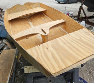
Just Add Water
The rainy weekend started off with overcast and fog but no rain. It looked like I might be able to get something done on the D4 dinghy. I wanted to change the bow seat which is really the bow deck. The sailing option uses the deck to hold the freestanding mast. I didn’t like how the deck looked, [...]
01 March 2024 | St. Marys, GA
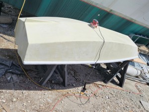
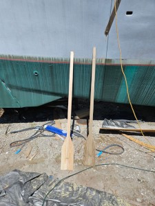
D4 Dinghy Alternative Seats
The rain event was more wind than rain, strong winds with gusts up to 44 mph. We drove into town to see what the harbor was like. There was a small sailboat that had dragged anchor and was sitting close to shore. The tide was out. We left and played with Bleu at Notter’s Pond.
23 February 2024 | St. Marys, GA
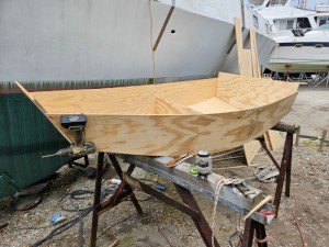
D4 Inside Seams
Day two of the dinghy build started out with me finishing wiring the hull bottoms together on the centerline of the bottom panels. This was much easier than the wiring of the chine edges of the bottom panels and the side panels.
The Arrival Part
.
We seemed to be constantly fighting an opposing current, no matter what time of day. Our speed over the ground would drop to 1.8 knots or something like that when I knew we were doing about 3 1/2 through the water.
.
At New River Inlet we ran into another confusing twisting of the channels and by following the boat icon on Marine Navigator Lite we avoided going off into a cul-de-sac. I saw a bridge on the chart display and saw that we could reach it at the top of the hour if we could get speed over the ground up to 5 knots. I gunned the engine and we ran along at a high rate. I had the radio set to channel 13, the bridge channel. As we got closer I called the bridge, no answer. I looked at the chart again and saw it was a high rise ICW bridge with about 65 feet of clearance under it. I backed off on the engine.
.
After a while we came upon a real opening bridge, the swing bridge at Surf City. We once again arrived just in time to watch it close and had to wait for the 7 PM opening. I thought I would anchor near the bridge and idled the engine, dropped the genoa, and pulled over to the side of the channel to see if I could anchor near the bridge. There was a sign, and when I got close enough to read it, it said, “No Anchoring”. Darn. I tacked back into the channel and found the current was much stronger near the bridge and I barely made it across. When I tried to tack back, the wind angle was bad and I was being swept into the closed bridge. Panic. I tacked back and the boat came to rest against the timber bumper that sits at an angle to the current. I quickly tied the boat to it with anything I could find, in this case, the end of the genoa sheet. The force of the current was very strong and pressed the boat against the timber. It wasn’t going anywhere. I started the engine which had conked out, and rev’d it up. It strained against the line I had tied, so I had to regulate the engine down to allow the line to be untied. Then rev again, push off the timber with the boathook, into the channel again, into the current. We made it back to where we started. The bridge called on channel 13 saying they were amazed I got the boat out of there. I said, “That one really tightened my screws”.
.
There was a 45 minute wait for the next opening and we motored through. It was getting near sunset, so I pulled over to the right side of the channel and anchored just outside the red daymarker. When the anchor line didn’t come taut, I realized we were aground. I started the engine and reversed, then pulled the anchor which pulled the boat backward. It slid back into the channel rather easily and I anchored there, close to the day mark.
.
Next we were getting boats coming by right and left as though we were in the center of the channel. I slept fitfully and got up to check our position several times during the night.
.
In the morning we got underway and grounded on the opposite side of the channel. There was almost no channel, that’s why we were getting buzzed by all those boats the evening before. We were aground, but with all sails set. That quick run up on deck to hoist sail wasn’t quick enough. I had to work some, brought the anchor aft and tossed it in, then went forward and pulled the boat around so it was facing the channel. This jibed the mainsail and I hoisted the genoa again, retrieved the anchor, started the engine and rev’d it up. We slowly crept toward the channel, helped by the wake of passing boats. I could feel the keel bouncing on the bottom. Then we were moving normally again.
.
We didn’t get too far, maybe 5 miles, and we grounded again. This time was serious, we were sailing along wing and wing with a good 10 knots or so breeze and I was standing holding the tiller. Suddenly I was thrown forward and slammed against the main hatch, sliding it all the way open. I was very surprised, because we were in what should have been the center of the channel. I called Sea Tow and expected quick service because I could see a Sea Tow dock only about a mile away. We had just passed it. They said they didn’t have anyone manning that station, so it would be a half hour for a boat to come down from Topsail Beach. It took more like 45 minutes, which would be similar to calling a tow truck for your car.
.
The problem that caused the grounding was the channel moves over to the left. The day mark there was missing its green sign on the side facing us, so it looked like two red marks to the right and an open channel going forward. If I had the navigation app running then, it would have shown me. I had to recharge the phone from time to time, or it would die completely.
.
The delay was about an hour and a half in total, not too bad when waiting for bridges to open causes an accumulated delay of about the same. I was now super vigilant about staying in the channel and running the navigation app. Then we came to another confusing set of day marks. It looked like a pair of green marks marking and entrance off to the left. I continued in the channel and suddenly felt that awful lurch when hitting the bottom. I quickly turned Trillium to the right, although I had thought that it was shallow over there, and a gust of wind came along to lay the boat down, lifting the keel a bit. We bumped along and were free. Just then a Tow Boat/US boat came into the channel from the side and I hailed him on the VHF about the shoal. He said there was deeper water right at the right bank of the channel.
.
Now I was getting worried about this inside route. We could have gone outside at Morehead City and sailed to Masonboro Inlet, which several skippers have recommended to me to do. I was conservative, though, due to tropical depression Julie which is stalled off the coast and giving us brisk fair winds in the ICW, but giving much stronger winds just off shore.
.
The next bridge was the Figure Eight swing bridge and once again we were there just in time to see it close. No excitement here, just a wait, then go through. It looked like we were on schedule to make it to the end of this part of the waterway. I searched for a marina with reasonable rates that had the services we needed. I found Joyner’s Marina which sits at the junction of the ICW and the Snow’s Cut channel that connects with the Cape Fear River.
.
Of course there was one more bridge, the lift bridge at Wrightsville. There was a lot of radio chatter about the current and one skipper was talking to another about how many rev’s to turn to keep from arriving too early. They were evidently large yachts that would have difficulty turning in the narrow channel. Everything in this neighborhood was large, huge mansions cheek by jowl lining the waterway.
.
When I got to the bridge it was only a 40 minute wait and the current was so strong I could sit motionless under power. Then the large motor yachts arrived. They were magnificent. No wonder there was so much concern about handling the current. They sat motionless in reverse. There were actually a lot of yachts waiting to go both North and South at the bridge. I wondered what kind of melee would happen when it opened. We all got in line and went through. The large yachts found room to turn and head into the adjacent marina where a band was playing and it looked like a good time to be had. I continued along with some smaller boats and they were fishing boats that zoomed off as soon as they were out of the congested area.
.
Now I called Joyner’s Marina and made reservations for a transient slip. It turned out they would not be open after 6 and I didn’t think I could make it before 7. They suggested I tie up at their gas dock and check in the following morning. I think they were concerned that I would tie up and leave early without paying, but I planned to take a day of rest and stay all day.
.
To fight the continually opposing tide current, I had sail hoisted and the engine running strongly. There was no need to conserve fuel, we were going to a gas dock. Even so, our speed dropped into the 3 knot range in spite of all the wind and horse power. The problem is that the tide schedule on this side of Cape Fear is different that from what we had gone through, so we were hitting the flood tide coming from Cape Fear River.
.
We won, though, and pulled into the marina’s gas dock just at sunset, tied up, showered, laundered, and this is being written while the laundry is drying.
.
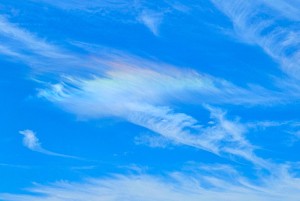
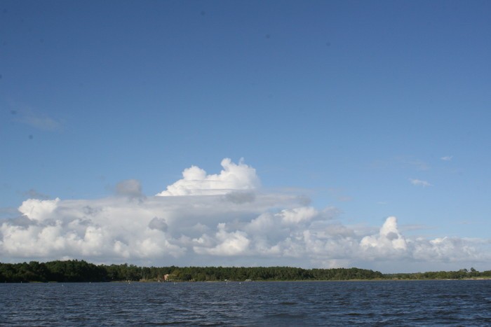
The photo is of an interesting cloud along the ICW.