Kaimusailing
s/v Kaimu Wharram Catamaran
| Vessel Name: | Kaimu |
| Vessel Make/Model: | Wharram Custom |
| Hailing Port: | Norwalk, CT |
| Crew: | Andy and the Kaimu Crew |
| About: | Sailors in the Baltimore, Annapolis, DC area. |
17 April 2024 | St Marys, GA
Dinghy Skeg
I was suffering with what seemed like a cold and also had allergy symptoms. I awoke and felt fine. The green pollen that was coating everything was gone. Maybe it will return.
07 April 2024 | St. Marys, GA
Clammy Hands
Items came in from TEMU, the Chinese cut rate retailer. One was a nice little drone that cost about twelve and a half dollars. It looked like an easy thing to play with while I coughed and sneezed. I was fighting a summer cold, even though it is not summer elsewhere, it seems like it here. A nice [...]

02 April 2024 | St. Marys, GA
Sun Doggie
After laminating the cedar strips onto the gunwales of the dinghy I found the screws I used wouldn’t come out. The epoxy had seized them. The screw heads were stripped so I cut a straight slot in the heads with the cut off wheel. The cedar smoked when the screw heads got red hot. I could remove [...]
21 March 2024 | St. Marys, GA
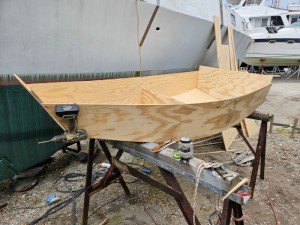
Just Add Water
The rainy weekend started off with overcast and fog but no rain. It looked like I might be able to get something done on the D4 dinghy. I wanted to change the bow seat which is really the bow deck. The sailing option uses the deck to hold the freestanding mast. I didn’t like how the deck looked, [...]
01 March 2024 | St. Marys, GA
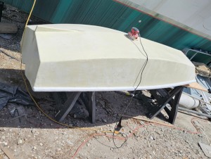
D4 Dinghy Alternative Seats
The rain event was more wind than rain, strong winds with gusts up to 44 mph. We drove into town to see what the harbor was like. There was a small sailboat that had dragged anchor and was sitting close to shore. The tide was out. We left and played with Bleu at Notter’s Pond.
23 February 2024 | St. Marys, GA
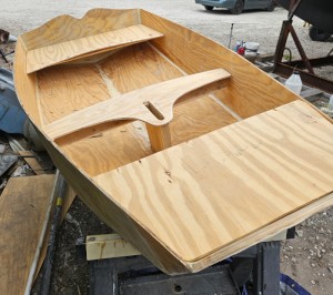
D4 Inside Seams
Day two of the dinghy build started out with me finishing wiring the hull bottoms together on the centerline of the bottom panels. This was much easier than the wiring of the chine edges of the bottom panels and the side panels.
Myrtle Beach to Charleston 1/2 Part
.
We got underway in the chilly morning. We could have enjoyed a couple hours more sleep, but if we waited too long we would lose the wind. If we left early we could possibly catch the NW 10-15 and hang on to it for a while. It was a fair breeze, broad on the starboard quarter, 120 degrees apparent. I wanted to see how this catamaran performed and was chagrined to see only 6-7 knots in 15 knots of wind. This is how fast this boat sails. Our earlier high speeds on Albemarle Sound were with assistance of the Westerbeke.
.
The course was set for the sea buoy off St. Marys Entrance, the entrance to Fernandina Beach. Distance was about 240 miles at about 240 degrees magnetic. We could see a difference between the compass and the GPS, which was set at magnetic, and the flux gate compass of the autopilot. The autopilot uses its own compass to follow courses. The problem is that it has no way to register being offset by a sideways current. If the boat is pointing in the right direction, the auto pilot does not make a correction, even if a strong current is pushing the boat way off course. We had noticed the GPS chart plotter display, which is set on “course up”, jitters from side to side as the GPS course information shifts. There should be a way to average the GPS course information so that the display doesn’t react to every jitter of GPS course. I do not know how the system on this boat was installed, or the details of the set up of the fundamental parameters, but it looks like they chose to have the autopilot reference its own flux gate compass instead of responding to GPS course information, because of the jitter of the GPS course information.
.
We tried sailing with the boards down to increase speed, but it didn’t seem to make any difference. It did make a difference in how the boat handled, it was “loose” with the boards up. We put the windward board down to steady things up.
.
As we sailed along our rumb line to Fernandina Beach, skipper got a text message from the boat’s owner saying he needed to contact us urgently. We were just outside cell phone coverage, so we headed straight for shore until we were able to call him. It turned out he wanted to make a change in plans and bring the boat to the St. Marys boatyard to haul it out and show a prospective buyer. This fit in with our plans, as we had decided to stop over at Fernandina Beach, and St. Marys was nearby.
.
The wind was getting lighter, so skipper decided to deploy the code zero sail. This is kind of like a spinnaker, made of heavier cloth though, and cut flat so that it can be used on a close reach. It was a lot of trouble to set the sail, due to it not being used often, but when it was up and flying, the boat took off.
.
We were heading SSW at 6-7 knots in 15 knots or so of apparent wind. When a gust would come through I would get a little anxious, the big sail was pulling so hard. Unfortunately the boat didn’t respond as it should, but it was going as fast as it could.
.
We took watches 4 on and 4 off. We expected the wind to die down and go further to the west and northwest. It didn’t happen. The wind was up to 20 knots at times and I was getting really concerned.
.
In the morning at first light we headed downwind to blanket the code zero and rolled the sail up. There were problems with the roller drum, it was jamming. Skipper got the sail rolled up manually, on deck in his PFD and clipped into his harness. We tried to get the genoa rolled out and working, but the wind was high and its direction from the WSW meant we had to head for Charleston or south and out to sea. We decided to go to Charleston. The forecast was for very high winds from the NE, so we wanted to wait that one out, maybe go down the ICW again.
.
It was my turn to go off watch and I went below and fell asleep, ignoring the boat’s engine, which sounds like a locomotive, and the waves crashing against the bridgedeck, which sounds like the boat is hitting the rocks. When I awoke we were motorsailing WNW to Charleston. It was the same approach I had taken with Kaimu back in 2002. I remember then it was 25 knots or so and I was sure we had hit 11 knots, but I couldn’t leave the helm to look at the chart display.
.
The wind was 15 to 20 and there was a lot of ship traffic through the port of Charleston. Skipper reserved a slip at the municipal marina and we motored in the long channel. It was flood tide and we were soon tied up.
.
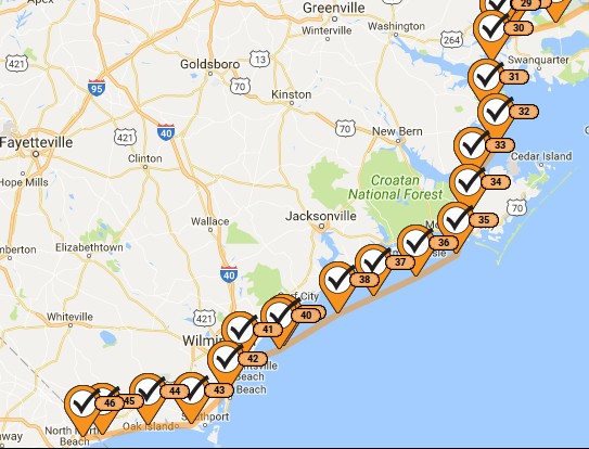
The image is of the SPOT tracking for the previous leg from Dowry Creek to the Myrtle Beach Yacht Club.