Kaimusailing
s/v Kaimu Wharram Catamaran
| Vessel Name: | Kaimu |
| Vessel Make/Model: | Wharram Custom |
| Hailing Port: | Norwalk, CT |
| Crew: | Andy and the Kaimu Crew |
| About: | Sailors in the Baltimore, Annapolis, DC area. |
17 April 2024 | St Marys, GA
Dinghy Skeg
I was suffering with what seemed like a cold and also had allergy symptoms. I awoke and felt fine. The green pollen that was coating everything was gone. Maybe it will return.
07 April 2024 | St. Marys, GA
Clammy Hands
Items came in from TEMU, the Chinese cut rate retailer. One was a nice little drone that cost about twelve and a half dollars. It looked like an easy thing to play with while I coughed and sneezed. I was fighting a summer cold, even though it is not summer elsewhere, it seems like it here. A nice [...]

02 April 2024 | St. Marys, GA
Sun Doggie
After laminating the cedar strips onto the gunwales of the dinghy I found the screws I used wouldn’t come out. The epoxy had seized them. The screw heads were stripped so I cut a straight slot in the heads with the cut off wheel. The cedar smoked when the screw heads got red hot. I could remove [...]
21 March 2024 | St. Marys, GA
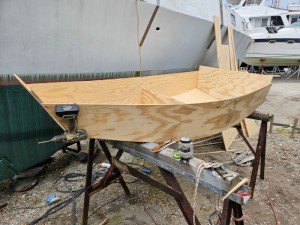
Just Add Water
The rainy weekend started off with overcast and fog but no rain. It looked like I might be able to get something done on the D4 dinghy. I wanted to change the bow seat which is really the bow deck. The sailing option uses the deck to hold the freestanding mast. I didn’t like how the deck looked, [...]
01 March 2024 | St. Marys, GA
D4 Dinghy Alternative Seats
The rain event was more wind than rain, strong winds with gusts up to 44 mph. We drove into town to see what the harbor was like. There was a small sailboat that had dragged anchor and was sitting close to shore. The tide was out. We left and played with Bleu at Notter’s Pond.
23 February 2024 | St. Marys, GA
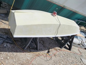
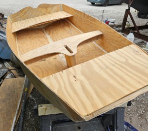
D4 Inside Seams
Day two of the dinghy build started out with me finishing wiring the hull bottoms together on the centerline of the bottom panels. This was much easier than the wiring of the chine edges of the bottom panels and the side panels.
Stowaway On Board
.
Instead of getting more sleep I remained on deck and we experienced some more glorious sailing with 15-20 on the beam and a steady boat speed of 8 1/2 knots. I tried some fine tuning of our sails and autopilot, as we were 1.7 miles to the right of our intended track. Great Inagua Island was coming up on our starboard, so it would be better to keep to our track than stray from it. In the planning stage the route is examined at highest detail to make sure there are no rocks, shoals, or other nasties along the way. On some vector charts objects that are visible at extreme zoom in are not visible when you zoom out. So, a route planned on a chart with less detail might have a buoy or a rock waiting, only to be found by hitting it or by taking the time to zoom in.
.
By coming left 5 degrees, our cross track error was eliminated quickly, our speed improved, and we were going in the direction of our next waypoint, not off on an angle. The distance to the waypoint was now about 160 miles, less than a day at these speeds.
.
Dinner was leftover pasta with meat sauce plus a new salad with cheddar and orange sweet peppers. Because we were sleeping in the daytime in shifts, almost like nighttime watch standing, dinner was dished out individually and Ron got his while I was asleep.
.
A sail that appeared on the horizon far behind us to the East gradually grew larger and passed us to starboard and too far off to make out much more than it was a sailing vessel. Because it was passing us and we were doing over 8 knots, it must be either a very large sailboat or a catamaran.
.
All three of us ended up on deck when Ron was coming on watch to relieve the skipper and I was up there unable to sleep. Skipper reported we have completed 1/3 of the route and are ahead of schedule. We are also saving diesel and making good time under sail. We pass just south of Great Inagua Island. A ship passes us starboard to starboard when we notice our starboard running light is out. Uh oh. It comes back on.
.
I took a look on this computer at our route using OpenCPN and I couldn’t find my GPS puck. I had another, but it hadn’t worked on this computer. Fortunately I had taken notes when I got it to work on the Getac computer and saved the notes on this one. This has been written up on the blog in the past and it involves reconfiguring GPSD to recognize an ACM device. When I made the change the puck worked and of course I found the missing Microsoft Pharos puck.
.
Once again I looked ahead on the route and it became apparent that we needn’t bother with the Cape Lucrecia separation zone, once we were clear of Great Iguana we could head straight for the entrance of Old Bahama Channel, so I changed our next waypoint to Old Baha Cha E, which was how it was entered in the chartplotter. The chartplotter is limited in length of names. This could create confusion such as P Cana (Punta Cana) being mistaken for Panama Canal. The waypoints can be sorted out so that they can be in groups which enables waypoints of same name to be put into different groups. P Cana would be in the Greater Antilles group, for instance, and Panama Canal would be in Western Caribbean, or in its own group of approaches to the canal.
.
Skipper wanted to put 2 reefs in the main before nightfall and I thought that might be excessively cautious. We already had one reef in it and a forecast of 20, we could just roll up more of the jib. The previous night we had been battling with a rain squall and wished we had a second reef in the main, so maybe that influenced his decision. As it turned out we lost no speed because as he said, the boat stands up more and projects more sail area. The motion of the boat was better and if a rain squall happened we would be well prepared.
.
The 3 man 3 hour watch scheme was working very well. It automatically rotates the watches so no one gets the same watch each day, over and over. There is a 6 hour gap between watches so the watchstander can get sleep if needed. We were exhausted after the rain squall chinese firedrill in the middle of the night and we kept to our schedule during the day and caught up on sleep.
.
I was able to get off watch at 5 PM and have 6 hours till I was on at 11 PM, then off at 2 AM until 8 AM, plenty of time for sleep. The previous night I stood 8 PM to 11PM, then off till 5 AM, probably the worst of the rotating schedule, but still enough to get almost 6 hours of sleep.