Kaimusailing
s/v Kaimu Wharram Catamaran
| Vessel Name: | Kaimu |
| Vessel Make/Model: | Wharram Custom |
| Hailing Port: | Norwalk, CT |
| Crew: | Andy and the Kaimu Crew |
| About: | Sailors in the Baltimore, Annapolis, DC area. |
07 April 2024 | St. Marys, GA
Clammy Hands
Items came in from TEMU, the Chinese cut rate retailer. One was a nice little drone that cost about twelve and a half dollars. It looked like an easy thing to play with while I coughed and sneezed. I was fighting a summer cold, even though it is not summer elsewhere, it seems like it here. A nice [...]

02 April 2024 | St. Marys, GA
Sun Doggie
After laminating the cedar strips onto the gunwales of the dinghy I found the screws I used wouldn’t come out. The epoxy had seized them. The screw heads were stripped so I cut a straight slot in the heads with the cut off wheel. The cedar smoked when the screw heads got red hot. I could remove [...]
21 March 2024 | St. Marys, GA
Just Add Water
The rainy weekend started off with overcast and fog but no rain. It looked like I might be able to get something done on the D4 dinghy. I wanted to change the bow seat which is really the bow deck. The sailing option uses the deck to hold the freestanding mast. I didn’t like how the deck looked, [...]
01 March 2024 | St. Marys, GA
D4 Dinghy Alternative Seats
The rain event was more wind than rain, strong winds with gusts up to 44 mph. We drove into town to see what the harbor was like. There was a small sailboat that had dragged anchor and was sitting close to shore. The tide was out. We left and played with Bleu at Notter’s Pond.
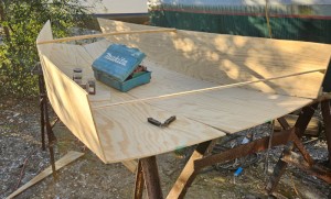
23 February 2024 | St. Marys, GA
D4 Inside Seams
Day two of the dinghy build started out with me finishing wiring the hull bottoms together on the centerline of the bottom panels. This was much easier than the wiring of the chine edges of the bottom panels and the side panels.
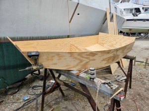
15 February 2024 | St. Marys, GA
D4 Dinghy Day One
A Wharram Pahi 26 had been anchored in the river nearby the boatyard and was hauled out with the travel lift. I went around to look at it and talked to the owner couple. I was surprised that it had been built in Martinique in 1988. The boat is more than 30 years old.
The Penguins Have Us

.
In correspondence and phone conversations I was getting observations of those up north, from Albany, NY, and Chicago, IL, Connecticut, Maryland, and from those on the Gulf Coast. I used weatherunderground.com to look at conditions in those places. Here in St Marys we are touching freezing in the overnight and only coming up to maybe 40 in the day. Down in the Keys, OK. Up in Albany my younger daughter had the heating system in her building fail on New Year’s Eve and it was a whole day for that to be fixed. Their forecast is nothing above freezing for the next week and a half, plus this heating failure occurred with minus temperatures. But conditions are much worse around the Great Lakes with double digit minus temperatures and most places have their abundant share of lake effect snow. Connecticut they complain, I was there and I did that, but inland Connecticut and Massachusetts can get snow from the ocean blowing in on a northeast wind. Maine, forget it, they are in the arctic.
.
So, I cannot fight the weather gods, I hunker down and fiddle around on the computer(s). I noticed I had plenty of Bahamas charts on one computer but only vector charts on the two others. The two others are the designated navigation computers, set up for use on a boat, not for internet or piling up a mess of photos, music, or any other non-oceanic stuff. But they only have the vector charts, no rasters. I found that I had a folder of raster charts that didn’t get transferred to those computers, so I ventured out, they are kept in the woodshop, closer to the water, and hopped on the bicycle, whose tires were very soft in the cold weather, air shrinks, and the handlebars felt like ice, those Chinese who didn’t send my handlebar tape, grrr, and the wind is blowing strong from the North, of course, so when I got to the woodshop, not that far, I was having cold symptoms returning, when I thought I was beating it. I began shivering spontaneously, no control over it, and that is a big sign of hypothermia, if you start shivering, take a mental note of what goes on afterwards. If you are having trouble thinking about it, that is one of the symptoms, trouble with fine motor coordination, lethargy, not that we don’t have those at other times, so I was having trouble typing on the computer and I thought maybe this is what it’s like when you get hit with Parkinson’s, loss of control. The little chart package of the Bahamas only took a minute or so to load, but it felt like forever. I finished up and sped back to the warm, relatively, boat. A Northerner.
.
I notice that as time goes on, my charts get more and more out of date. When I offer the oldest charts to the yardbirds, they say great, but they are not really enthusiastic, old charts are a danger, new stuff is happening along the coasts and hurricane damage and shifting of shoals, new construction, like wind farms, and of course buoys and lights can change, wrecks happen and usually right along the path you want to take. When I was a Navy sailor I went from radar to updating charts. It was a big job, and back then it was important to have good charts, there was nothing like instant updates from the internet. Now you have, for USA waters, very up to date free charts as well as Notice to Mariners, which advises what changes are happening right now. In the old days you updated a chart with electric erasers that rubbed out the wrong stuff and then added the update as best you could. Now it comes down the pipe already updated at high speed.
.
It looks like the marine electronics industry is going along like Microsoft vs. linux, that is, proprietary software and charts at hefty prices versus open source information that is free, except for a donation. I do donate to things that I understand are well meant and helpful, and those fellows who are working at it ought to get some compensation. Usually if I wanted to congratulate an open source provider, I would do it with a donation. It feels so good.
.
When you look at the evolution of marine charting, it is obvious that things in the future will be a lot different, markedly so when mariners have always been slow to adopt new things, there is always an old fashionedness, keeping old ways, speaking the old nautical tongue, resisting the modern stuff. Just as all of our staid old ways of communication have been overrun by modern online versions that are quicker and easier, charts have already lost their paper and now are becoming live online images that can be updated, corrected, and shared by almost anyone in port. The old salt that likes to make space on his boat for a good sized chart table, and likes to lean over it to mark things in light pencil, so it won’t be in the way Next Time, will learn that he doesn’t have to get so involved with the chart, it is electronically transportable, mutable, and now we have to have the same cautions of charts that we have with anything else from the internet, is it a “fake” chart.
.
The alternative is buying a chart package from one of the big marine electronics companies, and this is what the well heeled will do, buy the latest chartplotter with included charts. I’ve seen how this works out. If you are sailing, voyaging, it will be very expensive to get charts for the areas you will visit. You want to go to Bermuda, then go to the Azores, then to Portugal, and maybe the Med. You will come back via the Canaries to the Caribbean, and then work your way back to wherever you started from. I don’t think any chart package will cover all that trip, plus the little individual packages that are offered from the big marine guys will add up to a big expense in your voyaging budget.
.
Most people don’t have charting needs like that, they like to go out sailing for a few hours and then return to port. The package they paid for fits them very well. If they want to snow bird down to the Keys, which is not a bad idea right now, and then return to Raritan Bay, it will cost a little bit more, but not a whole lot. Many sailors sail just like that, up and down the coast, and they are always in familiar ground, no problems.
.
There is another type of sailor that is getting more popular and needing more attention from the big marine guys, the expedition sailors, who bring smaller boats to unfamiliar waters, they need coverage for their GPS for that new area. I identify with these guys, they return to the age old ethic of build it yourself, get it in the water, and why shouldn’t they have support from the big electronics guys, even though they are sailing a small boat, why should it cost so much?
.
And so there is a movement, by hands on boaters, to take care of this situation, since the big companies don’t even care about the DIY’ers. Why even cater to them? No money there, go after the big sportfishers and charter boats. That’s where the money is.
.
It’s like hiking and navigating your SUV. On the one hand, the hikers are in the minority and have other needs than the SUV’ers, who also include anyone using GPS navigation in any vehicle.
.
It’s funny how the expedition boaters and the hikers also include some of the most active DIY opensource programmers. There is a constant stream of new apps for you to just go out with your phone and tap into a resource of many many adept programmers who just want to work out how to get that function you want, and sometimes it’s free, sometimes you have to pay a few dollars. So unlike the big sportfishing electronics guys who want a lot of money for something you don’t really want, the alternative is friendly to you, whether you hike or sail along, and you can pick and choose from what’s available.
.
OK, the conditions of the night intrude, it is cold out there and it is coming in, I burn the stove with nothing on the flame, the little heater seems to have no affect.
.
When Fahrenheit invented his thermometer gauge, he came up with a strange gauge. Why was 32 the freezing point, but it turned out he had a definite scale in mind. His idea was to make each degree equal to what a human could determine as a temperature change, so 1 degree more was noticeable. There are theories about why 212 at boiling, but that‘s the way it works out.
.
We are not measuring degrees, we are burning things to maintain a habitable temperature on board. It will be cold like this for a couple of days. The penguin is the image that linux adopts, and is appropriate for this season.