s/v Skylark
It's Always An Adventure
02 September 2017 | Yarmouth, ME
02 September 2017 | Yarmouth, ME
01 January 2017 | Bethel, Maine
01 January 2017 | Bethel, Maine
13 December 2016 | Bethel, Maine
13 December 2016 | Bethel, Maine
13 December 2016 | Charlotte, NC
01 December 2016 | Charlotte, NC
01 December 2016 | Charlotte, NC
20 November 2016 | Washington DC/Charlotte NC
06 November 2016 | Bethel, Maine
06 November 2016 | Yarmouth, ME
26 October 2016 | Colombia, Cartagena (posted from Bethel, ME)
26 October 2016 | Bethel, Maine
16 October 2016 | Camden, Maine
16 October 2016 | Bethel, Maine
06 October 2016 | Bethel, Maine
06 October 2016 | Bethel, Maine
06 October 2016 | Bethel, Maine
02 October 2016 | Bethel, Maine
Hurricane Danny et. al
21 August 2015 | Bonaire, Kralendijk
Elizabeth (Internet photo)
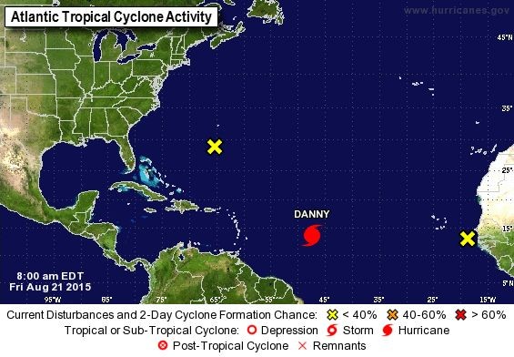
We are relieved to be in the ABC's below the hurricane belt, especially with the current activity in the Caribbean. We've been monitoring the situation but not with any concern for ourselves; mostly thinking of friends in Antigua and others in the VI's or with homes on St. Croix. Interestingly, a shopkeeper on Thursday told me the locals here were concerned about Hurricane Danny and shopping for food and water supplies. I said I was surprised to hear this since there's no forecast to suggest Danny would impact our area and she simply shrugged and waved her hands like everyone (other than her) were crazy. We checked in with our friends in Antigua and they're in good shape and I looked up the progress on FB of another friend outrunning the hurricane (or the potential of a problem), moving south from the Virgins to Grenada by himself. Here's Chris's weather update from last night and the photo from NOAA's website is from this morning. Some of you will have a big yawn while others might find it interesting. For cruisers or liveaboards it will be old hat.
"Wx Update, INTERIM TROPICAL - Invest97, etc. -, //WL2K R/ Thu20, 7p
In addition to Danny, we have Invest97 (near Bermuda), and Invest98 (off Africa), and there may be an Invet99 exiting Africa Sat22.
INVEST 97: models initialize broad, non-Tropical surface LO near 30N/68W, and move LO little thru Fri21. Invest97 should begin lifting N (or NW or NE) late Fri21 or Sat22, and there's a wide range of solutions.
We have discussed Invest97 since Mon17, so vessels transiting offshore waters between US Coast and Bermuda should find this no surprise. NOAA gives 20% chance Invest97 develops sufficient Tropical characteristics to be given a Number/Name thru Sat22, and a 60% chance thru Tue25.
Models which lift Invest97 N of GulfStream (to near 40N/68W Mon24) predict a weak system (20-30k sustained wind - and most of this N / E / SE of the LO).
Models which keep Invest97 near GulfStream predict much more strengthening (50-60k sustained strong TropicalStorm).
I have no opinion to offer on likely solution, but it makes lots of sense that intensity depends on whether Invest97 remains near GulfStream or not...and no significant changes from the Bahamas/US E Coast forecast emailed a couple hours ago.
*.*
INVEST 98: WAVE just off Africa may develop into Tropical LO as it moves W. NOAA gives 10% chance thru Sat22 / 30% chance thru Tue25. We have discussed this feature since Sat15. I give 50% chance Invest98 develops into Tropical LO thru Thu27, and possibly as soon as Sat22, when Invest98 passes S of CpVerdeIslands.
Models move Invest98 faster than Danny...GFS & EURO predict Invest98 makes its closest approach to E Caribbean (passing near Leewards) about Wed26 - or only 2 days after Danny. EURO predicts Invest98 absorbs Danny's remnant energy near or N of the Hispanola/Bahamas area Fri28-Sat29, and lies between Bermuda-Bahamas as a strong Hurricane Sun30-Mon31.
Given my opinion that Danny will not be a major problem for areas W of 60W, I am actually more concerned about Invest 98.
*.*
Another Tropical LO could follow about 4 days behind Invest98.
NEXT UPDATE on Danny and Invest97 / Invest98 Fri21, unless necessary sooner.
NOAA/USAF are flying a couple RECON missions to investigate Danny Fri21 afternoon, so I hope we can be more confident about Danny either Fri21 evening or Sat22...Chris."
Comments
| Vessel Name: | Skylark |
| Vessel Make/Model: | Bristol 41.1CC 1985 |
| Hailing Port: | Boothbay Harbor, Maine |
| Crew: | Ed Easter, Elizabeth Meadows and Luna the dog |
| About: | Ed, Elizabeth and Luna the dog lived for many years in Charlotte, NC. They started their live aboard experience in Charleston, SC in June 2011, cutting the lines one month later. They have been living the cruiser's life ever since. |
| Extra: |
Skylark's Photos - Main
 |
Three In A Boat

Who: Ed Easter, Elizabeth Meadows and Luna the dog
Port: Boothbay Harbor, Maine
Gallery