The First Mate's Journal
Where to next?
Great Lakes to The Bahamas
Who: Wayne & Pat
Port: Jackson
Favorites
05 November 2009 | Deltaville, VA
16 October 2009 | Deltaville, VA
27 May 2009 | Deltaville
26 May 2009 | Deltaville
25 May 2009 | Deltaville
24 May 2009 | Fishing Bay (N37*32.418 W76*20.203) to Deltaville
23 May 2009 | Great Bridge VA (N36*43.285 W76*14.508) to Fishing Bay VA (N37*32.418 W76*20.203)
22 May 2009 | Buck Island, NC (N36*16.034 W75*57.520) to Great BridgeVA (N36*43.285 W76*14.508)
21 May 2009 | The Alligator River Bridge, NC (N35*53.847 W76*02.024) to Buck Island, NC (N36*16.034 W75*57.520)
20 May 2009 | Alligator River Bridge, NC
19 May 2009 | Alligator River Swing Bridge, NC
17 May 2009 | The Pungo River, NC (N35*33.715 W76*28.557) to Alligator Swing Bridge, NC (N35*53.874 W76*02.024)
16 May 2009 | Eastham Creek Anchorage NC (N35*17.680 W76*36.514) to The Pungo River, NC (N35*33.715 W76*28.557)
15 May 2009 | Town Creek Marina, Beaufort NC (N34*43.519 W76*39.898) to Eastham Creek, NC (N35*17.680 W76*36.514)
14 May 2009 | Town Creek Marina, Beaufort, NC
13 May 2009 | Taylor Creek, Beaufort, NC (34*42.860 76*39.831) to Town Creek Marina, Beaufort, NC
12 May 2009 | Mile Hammock Bay (N34*33.163 W77*19.528) SM#244.5 to Taylor Creek, Beaufort, NC (34*42.860 76*39.831)
11 May 2009 | Wrightsville Beach NC (N34*12.441 W77*47.965) SM#283.2 to Mile Hammock Bay (N34*33.163 W77*19.528) SM#244.5
10 May 2009 | Shallottes Inlet, NC (N33*54.913)SM330 to Wrightsville Beach Anchorage (N34*12.447 W77*47.953)
09 May 2009 | Bull Creek, SC (N33 36.667 W79 06.228) to Shallottes Inlet, NC (N33*54.913)
Broken Throttle... to be repaired
16 September 2008 | Bannerman's Island aka Pollepel Isl. to Haverstraw Marina
Cool, cloudy
Well, after coffee Wayne had the wheel off, engine open and we were trying to figure out if the cable had come undone or had broken somewhere along the way. After following it from the engine to the steering - the conclusion was - a broken cable somewhere. We managed to get it loose from above but the casing stayed attached from below. The metal was definitely broken clean.
At low tide, surrounded by shallows and a current running 3 times faster than our idle speed, we decided that it wasn't smart to try to up anchor and motor out at idle. One option was to manually control it from below - adjusting the throttle from near the engine (set it at 1000 to 2000 rpms - need almost 2000 to counter the currents) but once the engine compartment was open and running it seemed like one of us had to remain below also not an option for the windlass and steering or we needed to do it at a high speed.
Sailing to get out at low tide, high current and the wind against us - not an option. Option? Do our cell phones work out here? YES! Call Boat US... We have unlimited towing. Undignified for a sailboat - but one way of getting out of the shallows near the castle ruins. Boat US had nobody in our area (gave them our position with Longitude and Latitude) but put us in touch with SeaTow and said that they'd reimburse us, send them a fax of the bill. Sea Tow called us back and they were out on a run but would get back to us ASAP. They called us back and we had about an hour and half wait for them so I made a scrambled concoction of egg, potatoes, peppers, ham, onion, and whatever else for breakfast while we waited.
When he showed up (Walter) he was most cordial and explained the process of the tow. The cost - cough, cough... $275/hour and we were looking at 3 hours plus to get to a place that could work on sailboats. He asked which way we were going - north or south so of course we chose south (why go back from where we came, specially if there was nowhere to get the parts and labor). We got hooked up and the tow was on.
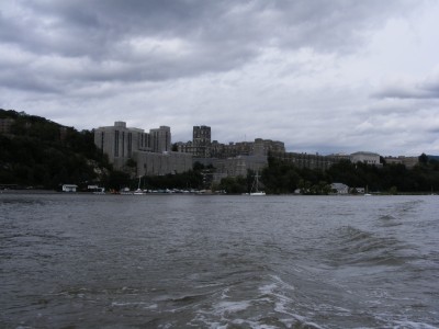
Not exactly the way I wanted to see West Point from the water but - yikes - I didn't know this boat could move so fast... Mike was right - West Point looks like Hogwart's from the water - quite impressive. We wouldn't have been able to anchor here or dock at West Point though - since security measures in place now forbid it.
Probably some of the best scenery on the Hudson River was along this stretch. The narrow section of the river we passed through is designated as "The Worlds End." It is the deepest section of the entire river (around 175 ft). Storm King Mountain - 1355 ft peak - spectacular, Bear Mountain (had the longest suspension bridge in 1924 - Big Mack has it beat all to hell now), Dunderberg Mountain (a legendary 1,000 ft legendary dwelling of the Dutch Goblin held responsible for summer storms) all magnificent old remnants of ancient mountains. I guess that during the Revolutionary War, we stretched a huge chain across the Hudson north of Bear Mountain Bridge to prevent the British warships from passing. But they seized the chain, sent it to Gibralter (to protect their harbor) then went on to Kingstorn and burned the town down. Anyhow the Appalachian Mountain chain that we passed through was gorgeous. The old granite remnants of the mountain roots visible under layers of twisted rock and capped with tall trees in the distance were a delight for my eyes.
We passed by a nuclear power plant that had no cooling towers... I asked Walter about it - he said they cool it by the river water which was a bone of contention for many because of the amount of fish it destroys (wow, I thought they couldn't do that - it must be grand fathered in). I'm not familiar with it but I guess striped bass is a very popular fish here that gets sucked up into the cooling water. We got to the Haverstraw Bay and the Marina about 3pm and they charge you from the time they leave their port so we were looking at a 3 hour 40 minute bill. Ouch...Boat US better come through... One note of history here - Haverstraw Bay (the widest part of the Hudson at 3 miles across) is the place in 1780 where Benedict Arnold schemed to betray and surrender West Point with British Major John Andre. The tree where they hanged Andre still stands in the town square of Tappan.
Once we were tied up at the T Dock, the mechanic got here pretty quickly, but none of us could figure out what was holding the cable from coming loose near the column. Turns out it was a screw that locked the cable to the column that wasn't easily accessible. Pretty tricky these Bayfield People... Finally got it out and the part ordered. We were told it'd be here in the morning.
It looks like things get more expensive the closer we get to NY. Here it costs $2.50 a foot for berthing plus another $7 for power. This is one expensive day...
This is one of many photos I shot going past West Point at 9.0 knots... (who say's a Bayfield can't go fast...)
At low tide, surrounded by shallows and a current running 3 times faster than our idle speed, we decided that it wasn't smart to try to up anchor and motor out at idle. One option was to manually control it from below - adjusting the throttle from near the engine (set it at 1000 to 2000 rpms - need almost 2000 to counter the currents) but once the engine compartment was open and running it seemed like one of us had to remain below also not an option for the windlass and steering or we needed to do it at a high speed.
Sailing to get out at low tide, high current and the wind against us - not an option. Option? Do our cell phones work out here? YES! Call Boat US... We have unlimited towing. Undignified for a sailboat - but one way of getting out of the shallows near the castle ruins. Boat US had nobody in our area (gave them our position with Longitude and Latitude) but put us in touch with SeaTow and said that they'd reimburse us, send them a fax of the bill. Sea Tow called us back and they were out on a run but would get back to us ASAP. They called us back and we had about an hour and half wait for them so I made a scrambled concoction of egg, potatoes, peppers, ham, onion, and whatever else for breakfast while we waited.
When he showed up (Walter) he was most cordial and explained the process of the tow. The cost - cough, cough... $275/hour and we were looking at 3 hours plus to get to a place that could work on sailboats. He asked which way we were going - north or south so of course we chose south (why go back from where we came, specially if there was nowhere to get the parts and labor). We got hooked up and the tow was on.
Not exactly the way I wanted to see West Point from the water but - yikes - I didn't know this boat could move so fast... Mike was right - West Point looks like Hogwart's from the water - quite impressive. We wouldn't have been able to anchor here or dock at West Point though - since security measures in place now forbid it.
Probably some of the best scenery on the Hudson River was along this stretch. The narrow section of the river we passed through is designated as "The Worlds End." It is the deepest section of the entire river (around 175 ft). Storm King Mountain - 1355 ft peak - spectacular, Bear Mountain (had the longest suspension bridge in 1924 - Big Mack has it beat all to hell now), Dunderberg Mountain (a legendary 1,000 ft legendary dwelling of the Dutch Goblin held responsible for summer storms) all magnificent old remnants of ancient mountains. I guess that during the Revolutionary War, we stretched a huge chain across the Hudson north of Bear Mountain Bridge to prevent the British warships from passing. But they seized the chain, sent it to Gibralter (to protect their harbor) then went on to Kingstorn and burned the town down. Anyhow the Appalachian Mountain chain that we passed through was gorgeous. The old granite remnants of the mountain roots visible under layers of twisted rock and capped with tall trees in the distance were a delight for my eyes.
We passed by a nuclear power plant that had no cooling towers... I asked Walter about it - he said they cool it by the river water which was a bone of contention for many because of the amount of fish it destroys (wow, I thought they couldn't do that - it must be grand fathered in). I'm not familiar with it but I guess striped bass is a very popular fish here that gets sucked up into the cooling water. We got to the Haverstraw Bay and the Marina about 3pm and they charge you from the time they leave their port so we were looking at a 3 hour 40 minute bill. Ouch...Boat US better come through... One note of history here - Haverstraw Bay (the widest part of the Hudson at 3 miles across) is the place in 1780 where Benedict Arnold schemed to betray and surrender West Point with British Major John Andre. The tree where they hanged Andre still stands in the town square of Tappan.
Once we were tied up at the T Dock, the mechanic got here pretty quickly, but none of us could figure out what was holding the cable from coming loose near the column. Turns out it was a screw that locked the cable to the column that wasn't easily accessible. Pretty tricky these Bayfield People... Finally got it out and the part ordered. We were told it'd be here in the morning.
It looks like things get more expensive the closer we get to NY. Here it costs $2.50 a foot for berthing plus another $7 for power. This is one expensive day...
This is one of many photos I shot going past West Point at 9.0 knots... (who say's a Bayfield can't go fast...)
Comments
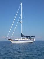
| Vessel Name: | Kolibrie |
| Vessel Make/Model: | Bayfield 36 |
| Hailing Port: | Jackson |
| Crew: | Wayne & Pat |
| About: | Back in Michigan for Hurricane Season 2009... |
| Extra: | Our boat is a Bayfield 36. Not the fastest little thing, but a nice little cruiser that we like to call home. |
| Home Page: | www.kolibrie.us |
Gallery not available
Great Lakes to The Bahamas
Who: Wayne & Pat
Port: Jackson