The First Mate's Journal
Where to next?
Great Lakes to The Bahamas
Who: Wayne & Pat
Port: Jackson
Favorites
05 November 2009 | Deltaville, VA
16 October 2009 | Deltaville, VA
27 May 2009 | Deltaville
26 May 2009 | Deltaville
25 May 2009 | Deltaville
24 May 2009 | Fishing Bay (N37*32.418 W76*20.203) to Deltaville
23 May 2009 | Great Bridge VA (N36*43.285 W76*14.508) to Fishing Bay VA (N37*32.418 W76*20.203)
22 May 2009 | Buck Island, NC (N36*16.034 W75*57.520) to Great BridgeVA (N36*43.285 W76*14.508)
21 May 2009 | The Alligator River Bridge, NC (N35*53.847 W76*02.024) to Buck Island, NC (N36*16.034 W75*57.520)
20 May 2009 | Alligator River Bridge, NC
19 May 2009 | Alligator River Swing Bridge, NC
17 May 2009 | The Pungo River, NC (N35*33.715 W76*28.557) to Alligator Swing Bridge, NC (N35*53.874 W76*02.024)
16 May 2009 | Eastham Creek Anchorage NC (N35*17.680 W76*36.514) to The Pungo River, NC (N35*33.715 W76*28.557)
15 May 2009 | Town Creek Marina, Beaufort NC (N34*43.519 W76*39.898) to Eastham Creek, NC (N35*17.680 W76*36.514)
14 May 2009 | Town Creek Marina, Beaufort, NC
13 May 2009 | Taylor Creek, Beaufort, NC (34*42.860 76*39.831) to Town Creek Marina, Beaufort, NC
12 May 2009 | Mile Hammock Bay (N34*33.163 W77*19.528) SM#244.5 to Taylor Creek, Beaufort, NC (34*42.860 76*39.831)
11 May 2009 | Wrightsville Beach NC (N34*12.441 W77*47.965) SM#283.2 to Mile Hammock Bay (N34*33.163 W77*19.528) SM#244.5
10 May 2009 | Shallottes Inlet, NC (N33*54.913)SM330 to Wrightsville Beach Anchorage (N34*12.447 W77*47.953)
09 May 2009 | Bull Creek, SC (N33 36.667 W79 06.228) to Shallottes Inlet, NC (N33*54.913)
Goodbye NC, Hello SC
23 November 2008 | Southport NC to Coquina Harbor SC (N35 51.852 x W78 38.295)
Temps in the Mid 50s Winds NE 10 changing to SE 5 later in the day
Cape Fear has an interesting history from pirates to treacherous shoals where the mighty Atlantic rolls in here with amazing force. It's earned the nickname of the Graveyard of the Atlantic with reason. We faced going through here with some trepidation first because we were heading out at low tide and there were several problem spots along the way that we needed to watch out for - at Lockwood's Folly several boats ahead of us had run aground in shoaling and the intersection of the ICW and Shallotte Inlet the same held true. We also had to make sure to be careful at the bridge construction where it became very shallow. We managed to make it along this stretch with little problem by using extreme caution in the trouble spots but almost lost it at Calabash. I saw a line of sailboats and started following them - they were all headed towards two Towboat US boats near a red beacon and I thought they were following the channel - only they weren't - they were going into a shallow anchorage. I watched my depths change to 8 ft, 6 ft and thought - ohhhhhh ohhhh, then swerved and made my way back into the channel. Close one!
We went through a pontoon bridge today - first one I ever saw - interesting - they move that section for vessels to pass and because it's a pontoon bridge they won't open it at low tide (they can't).
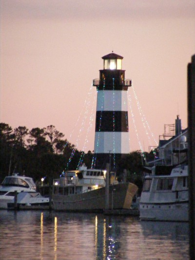
We got in at 5pm - hard to see with the sun setting in our eyes but we made it in just at dark. There's a lighthouse that signals you've reached the marina - pretty cool looking. Maneuvering in was a bit tricky to find our marina though - there's 3 or 4 marinas in here (I made reservations this morning at the Coquina Yacht Club), and they book up quickly too, so I called this morning before leaving to make sure we had a spot. It's an interesting spot - it used to be a coquina quarry (the sedimentary rock that looks like shell fragments) but as they kept quarrying, they went below water level and flooded the mine site, then tried to fill it in with other materials that kept washing out, so finally left it be to become waterfront property/marinas. Sandy was here to meet us with her husband - they've been together 48 years - and manage the Coquina Yacht Club Marina. I really liked her. We chatted with them for a while, then helped 3 other boats come in. We'd heard/saw them back at the pontoon bridge coming up hard behind us but they didn't make it for the bridge opening and had to wait for the next opening at 4pm (it only opens on the hour).
Made Steak and salad for dinner and we had sourdough hardrolls with it. Long hard day (stressful avoiding shallows) but I finished it off with a nice meal... Happy Anniversary Capt'n.
Tomorrow we face the infamous "rock pile". When the Army Corp began this cut, they didn't realize they would be digging through Cretaceous Limestone and marl pits. This limestone varies from 65-144 million years old and formed at the end of the age of dinosaurs and the ledges underwater have been know to damage many boats. It worries me because we'll be transiting this area at low tide so the possibility exists that we may encounter these underwater ledges if we're not careful...
Comments
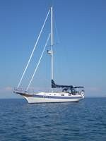
| Vessel Name: | Kolibrie |
| Vessel Make/Model: | Bayfield 36 |
| Hailing Port: | Jackson |
| Crew: | Wayne & Pat |
| About: | Back in Michigan for Hurricane Season 2009... |
| Extra: | Our boat is a Bayfield 36. Not the fastest little thing, but a nice little cruiser that we like to call home. |
| Home Page: | www.kolibrie.us |
Gallery not available
Great Lakes to The Bahamas
Who: Wayne & Pat
Port: Jackson