The First Mate's Journal
Where to next?
Great Lakes to The Bahamas
Who: Wayne & Pat
Port: Jackson
Favorites
05 November 2009 | Deltaville, VA
16 October 2009 | Deltaville, VA
27 May 2009 | Deltaville
26 May 2009 | Deltaville
25 May 2009 | Deltaville
24 May 2009 | Fishing Bay (N37*32.418 W76*20.203) to Deltaville
23 May 2009 | Great Bridge VA (N36*43.285 W76*14.508) to Fishing Bay VA (N37*32.418 W76*20.203)
22 May 2009 | Buck Island, NC (N36*16.034 W75*57.520) to Great BridgeVA (N36*43.285 W76*14.508)
21 May 2009 | The Alligator River Bridge, NC (N35*53.847 W76*02.024) to Buck Island, NC (N36*16.034 W75*57.520)
20 May 2009 | Alligator River Bridge, NC
19 May 2009 | Alligator River Swing Bridge, NC
17 May 2009 | The Pungo River, NC (N35*33.715 W76*28.557) to Alligator Swing Bridge, NC (N35*53.874 W76*02.024)
16 May 2009 | Eastham Creek Anchorage NC (N35*17.680 W76*36.514) to The Pungo River, NC (N35*33.715 W76*28.557)
15 May 2009 | Town Creek Marina, Beaufort NC (N34*43.519 W76*39.898) to Eastham Creek, NC (N35*17.680 W76*36.514)
14 May 2009 | Town Creek Marina, Beaufort, NC
13 May 2009 | Taylor Creek, Beaufort, NC (34*42.860 76*39.831) to Town Creek Marina, Beaufort, NC
12 May 2009 | Mile Hammock Bay (N34*33.163 W77*19.528) SM#244.5 to Taylor Creek, Beaufort, NC (34*42.860 76*39.831)
11 May 2009 | Wrightsville Beach NC (N34*12.441 W77*47.965) SM#283.2 to Mile Hammock Bay (N34*33.163 W77*19.528) SM#244.5
10 May 2009 | Shallottes Inlet, NC (N33*54.913)SM330 to Wrightsville Beach Anchorage (N34*12.447 W77*47.953)
09 May 2009 | Bull Creek, SC (N33 36.667 W79 06.228) to Shallottes Inlet, NC (N33*54.913)
On the road or into the ditch...
26 January 2009 | Vero Beach FL (N27*39.399 x W80*22.262) to Peck Lake FL (N27*06.863 x W80*08.563)
Partly Sunny High 70, Low 50
Monday, January 26, 2009
On the "road" again or should I say, "ditch". After coffee we cast off the mooring and headed to the marina dock for fuel, pump out water and a last look at Vero Beach Marina then we were off headed south again at 9:00am. The weather is nice today; the sun keeps shining through the clouds (mostly fair weather clouds). It was funny because while at the helm, I was acutely aware of the breeze blowing across the cockpit. A cool air whispered ever so briefly across the skin, on my arms & shoulders, tickling the little hairs there as the sun disappeared behind a cloud. When the sun's out it's perfect, but the air seems to be much cooler when the sun disappears behind the clouds. One minute we're all covered up and the next minute, off come the sweatshirts. It's that kind of day - sunny but still able to raise goose bumps in the breeze.
It's nice to see blue/green water again. The water at Vero was always a muddy brown color. We had dolphins around us again whenever we neared an inlet - it's interesting to watch them hunt. They team up and circle the small fry to round them up and then seem to pounce on the minnows.
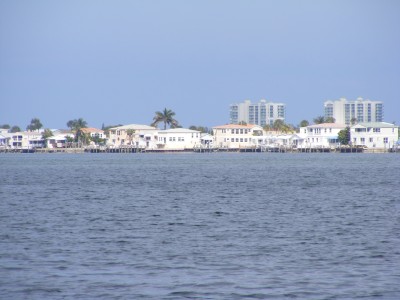
Passing Red buoy 172 there was an oceanographic institution that was new to me - Harbor Branch Oceanographic Institution - right before Fort Pierce. I'll have to look them up and see what they specialize it. We also passed an interesting island today - perfectly square in shape, with trailers and prefab homes on them. I've never seen such a thing. It's called Nettles Island. It must be some way of garnering more water front property or something - but it's packed - wall to wall with homes. The picture is one of our views of it - doesn't quite show it in it's entire square though.
I swear the water keeps getting skinnier and skinnier the farther south we go. Most of the way to Peck Lake seemed like it was between 8-10 ft and you'd think that it was still the weekend - I couldn't believe the amount of boat traffic and people out fishing. I'm not sure why they need to anchor "in" the channel to fish though. All this water from shore to the channel will accommodate the draft (depth) of most of the fishing boats and pontoons but it won't accommodate the draft on boats like ours that have to stay in the channel and yet they persist in anchoring in the channel. Perhaps they're secretly trying to run us aground, or trying to collect on some insurance, as we have to run into them? LOL... whatever...
In trying to anchor in Peck Lake, I did run aground. But I expected to because I wasn't sure where the shoal was and most of this area is very shallow so I had to nose around looking for where to get into the anchorage. We nosed in, grounded (ever so lightly), backed out, and circled and then "Our Way" a powerboat/yacht (I think I remember them from another anchorage but I'm not sure where), radioed directions on where to get into the anchorage (up to the danger sign at the weather station and to the north of them). I was really grateful for the assist. My depth sounder read 5.5 as Wayne dropped anchor and I happily backed up as he dropped anchor. I realize that our depth sounder is maybe a couple feet below the water level, but I get really nervous when we approach that 5 ft depth because right after that we go "clunk".
I can hear the waves from the Atlantic washing ashore from the anchorage. I think tomorrow we'll go investigate it. It's on the other side of Jupiter Island and we're on the ICW side of it in Peck Lake.
By the way - I almost forgot! Happy New Years! Today is the Chinese New Year and so begins the year of the Ox. It lasts from January 26, 2009 to February 14, 2010. Based on traditional beliefs, some form of this quasi-lunar calendar has been in use for almost five millennia. Based on archaeological evidence some form of it has been in use for three and a half millennia. It is the year 4705, 4706, or 4645 (depending on the epoch used). In ancient China, the new year began on the second new moon after the winter solstice (in times under some other dynasties in ancient China, the year might occasionally have begun on the first or third new moon after winter solstice). But since the time of the Emperor Wu of Han, starting the new year on the second new moon after winter solstice has been the norm for more than two thousand years. So the year of the Rat is over and the year of the Ox starts today.
Soooo Gōngxǐ fācái (sounds like - gung he fat choy) time to kick back and celebrate with a beer (in my case probably a diet coke or green tea - beer for Wayne LOL).
On the "road" again or should I say, "ditch". After coffee we cast off the mooring and headed to the marina dock for fuel, pump out water and a last look at Vero Beach Marina then we were off headed south again at 9:00am. The weather is nice today; the sun keeps shining through the clouds (mostly fair weather clouds). It was funny because while at the helm, I was acutely aware of the breeze blowing across the cockpit. A cool air whispered ever so briefly across the skin, on my arms & shoulders, tickling the little hairs there as the sun disappeared behind a cloud. When the sun's out it's perfect, but the air seems to be much cooler when the sun disappears behind the clouds. One minute we're all covered up and the next minute, off come the sweatshirts. It's that kind of day - sunny but still able to raise goose bumps in the breeze.
It's nice to see blue/green water again. The water at Vero was always a muddy brown color. We had dolphins around us again whenever we neared an inlet - it's interesting to watch them hunt. They team up and circle the small fry to round them up and then seem to pounce on the minnows.
Passing Red buoy 172 there was an oceanographic institution that was new to me - Harbor Branch Oceanographic Institution - right before Fort Pierce. I'll have to look them up and see what they specialize it. We also passed an interesting island today - perfectly square in shape, with trailers and prefab homes on them. I've never seen such a thing. It's called Nettles Island. It must be some way of garnering more water front property or something - but it's packed - wall to wall with homes. The picture is one of our views of it - doesn't quite show it in it's entire square though.
I swear the water keeps getting skinnier and skinnier the farther south we go. Most of the way to Peck Lake seemed like it was between 8-10 ft and you'd think that it was still the weekend - I couldn't believe the amount of boat traffic and people out fishing. I'm not sure why they need to anchor "in" the channel to fish though. All this water from shore to the channel will accommodate the draft (depth) of most of the fishing boats and pontoons but it won't accommodate the draft on boats like ours that have to stay in the channel and yet they persist in anchoring in the channel. Perhaps they're secretly trying to run us aground, or trying to collect on some insurance, as we have to run into them? LOL... whatever...
In trying to anchor in Peck Lake, I did run aground. But I expected to because I wasn't sure where the shoal was and most of this area is very shallow so I had to nose around looking for where to get into the anchorage. We nosed in, grounded (ever so lightly), backed out, and circled and then "Our Way" a powerboat/yacht (I think I remember them from another anchorage but I'm not sure where), radioed directions on where to get into the anchorage (up to the danger sign at the weather station and to the north of them). I was really grateful for the assist. My depth sounder read 5.5 as Wayne dropped anchor and I happily backed up as he dropped anchor. I realize that our depth sounder is maybe a couple feet below the water level, but I get really nervous when we approach that 5 ft depth because right after that we go "clunk".
I can hear the waves from the Atlantic washing ashore from the anchorage. I think tomorrow we'll go investigate it. It's on the other side of Jupiter Island and we're on the ICW side of it in Peck Lake.
By the way - I almost forgot! Happy New Years! Today is the Chinese New Year and so begins the year of the Ox. It lasts from January 26, 2009 to February 14, 2010. Based on traditional beliefs, some form of this quasi-lunar calendar has been in use for almost five millennia. Based on archaeological evidence some form of it has been in use for three and a half millennia. It is the year 4705, 4706, or 4645 (depending on the epoch used). In ancient China, the new year began on the second new moon after the winter solstice (in times under some other dynasties in ancient China, the year might occasionally have begun on the first or third new moon after winter solstice). But since the time of the Emperor Wu of Han, starting the new year on the second new moon after winter solstice has been the norm for more than two thousand years. So the year of the Rat is over and the year of the Ox starts today.
Soooo Gōngxǐ fācái (sounds like - gung he fat choy) time to kick back and celebrate with a beer (in my case probably a diet coke or green tea - beer for Wayne LOL).
Comments
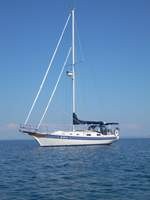
| Vessel Name: | Kolibrie |
| Vessel Make/Model: | Bayfield 36 |
| Hailing Port: | Jackson |
| Crew: | Wayne & Pat |
| About: | Back in Michigan for Hurricane Season 2009... |
| Extra: | Our boat is a Bayfield 36. Not the fastest little thing, but a nice little cruiser that we like to call home. |
| Home Page: | www.kolibrie.us |
Gallery not available
Great Lakes to The Bahamas
Who: Wayne & Pat
Port: Jackson