The First Mate's Journal
Where to next?
Great Lakes to The Bahamas
Who: Wayne & Pat
Port: Jackson
Favorites
05 November 2009 | Deltaville, VA
16 October 2009 | Deltaville, VA
27 May 2009 | Deltaville
26 May 2009 | Deltaville
25 May 2009 | Deltaville
24 May 2009 | Fishing Bay (N37*32.418 W76*20.203) to Deltaville
23 May 2009 | Great Bridge VA (N36*43.285 W76*14.508) to Fishing Bay VA (N37*32.418 W76*20.203)
22 May 2009 | Buck Island, NC (N36*16.034 W75*57.520) to Great BridgeVA (N36*43.285 W76*14.508)
21 May 2009 | The Alligator River Bridge, NC (N35*53.847 W76*02.024) to Buck Island, NC (N36*16.034 W75*57.520)
20 May 2009 | Alligator River Bridge, NC
19 May 2009 | Alligator River Swing Bridge, NC
17 May 2009 | The Pungo River, NC (N35*33.715 W76*28.557) to Alligator Swing Bridge, NC (N35*53.874 W76*02.024)
16 May 2009 | Eastham Creek Anchorage NC (N35*17.680 W76*36.514) to The Pungo River, NC (N35*33.715 W76*28.557)
15 May 2009 | Town Creek Marina, Beaufort NC (N34*43.519 W76*39.898) to Eastham Creek, NC (N35*17.680 W76*36.514)
14 May 2009 | Town Creek Marina, Beaufort, NC
13 May 2009 | Taylor Creek, Beaufort, NC (34*42.860 76*39.831) to Town Creek Marina, Beaufort, NC
12 May 2009 | Mile Hammock Bay (N34*33.163 W77*19.528) SM#244.5 to Taylor Creek, Beaufort, NC (34*42.860 76*39.831)
11 May 2009 | Wrightsville Beach NC (N34*12.441 W77*47.965) SM#283.2 to Mile Hammock Bay (N34*33.163 W77*19.528) SM#244.5
10 May 2009 | Shallottes Inlet, NC (N33*54.913)SM330 to Wrightsville Beach Anchorage (N34*12.447 W77*47.953)
09 May 2009 | Bull Creek, SC (N33 36.667 W79 06.228) to Shallottes Inlet, NC (N33*54.913)
On to Ashtabula
18 August 2008 | Fairport Harbor to Ashtabula (N41o55.1� W080o47.8
Wonderful!!!
Nice sailing day - we averaged 6.35 knots today and it felt good to sail - running with the wind all day (hey isn't that a Bob Segar tune?) with all sails up. From Fairport we could see huge cooling towers in the distance for the Perry Nuclear Facilities and as we got closer I thought why not... 15 minute sketch with my colored pencils... I discovered that I have no perspective when it comes to drawing rolling waves... but it was fun to sketch again - it's been a while since I've picked up a pencil in Marcie's art room.
We put into Ashtabula at 2:45pm and Carpe' Diem was anchored already there. Looks like a mud bottom - 10-15 ft depths. They'd left in the morning about a half hour before us and it looks like they're heading in the same direction as us. We don't have our dingy in the water yet so I can't go over and chat with them. They don't have their ears on either so we'll wait a bit to contact them. It'd be nice to meet another couple doing the same thing as us.
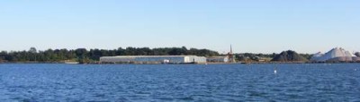
Ashtabula is an interesting looking harbor. It has major iron piles and coal piles. We watched them unloading a freighter most of the evening and into the night too. A little history - The name Ashtabula is a Native American term meaning "many fish". The river was the boundary between the eastern and western tribes with the Iroquois claiming the western territory and the Algonquin claiming the land to the east. This was also the northern terminus of the "underground railroad" before the Civil War.
We put into Ashtabula at 2:45pm and Carpe' Diem was anchored already there. Looks like a mud bottom - 10-15 ft depths. They'd left in the morning about a half hour before us and it looks like they're heading in the same direction as us. We don't have our dingy in the water yet so I can't go over and chat with them. They don't have their ears on either so we'll wait a bit to contact them. It'd be nice to meet another couple doing the same thing as us.
Ashtabula is an interesting looking harbor. It has major iron piles and coal piles. We watched them unloading a freighter most of the evening and into the night too. A little history - The name Ashtabula is a Native American term meaning "many fish". The river was the boundary between the eastern and western tribes with the Iroquois claiming the western territory and the Algonquin claiming the land to the east. This was also the northern terminus of the "underground railroad" before the Civil War.
Comments
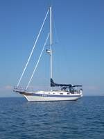
| Vessel Name: | Kolibrie |
| Vessel Make/Model: | Bayfield 36 |
| Hailing Port: | Jackson |
| Crew: | Wayne & Pat |
| About: | Back in Michigan for Hurricane Season 2009... |
| Extra: | Our boat is a Bayfield 36. Not the fastest little thing, but a nice little cruiser that we like to call home. |
| Home Page: | www.kolibrie.us |
Gallery not available
Great Lakes to The Bahamas
Who: Wayne & Pat
Port: Jackson