The First Mate's Journal
Where to next?
Great Lakes to The Bahamas
Who: Wayne & Pat
Port: Jackson
Favorites
05 November 2009 | Deltaville, VA
16 October 2009 | Deltaville, VA
27 May 2009 | Deltaville
26 May 2009 | Deltaville
25 May 2009 | Deltaville
24 May 2009 | Fishing Bay (N37*32.418 W76*20.203) to Deltaville
23 May 2009 | Great Bridge VA (N36*43.285 W76*14.508) to Fishing Bay VA (N37*32.418 W76*20.203)
22 May 2009 | Buck Island, NC (N36*16.034 W75*57.520) to Great BridgeVA (N36*43.285 W76*14.508)
21 May 2009 | The Alligator River Bridge, NC (N35*53.847 W76*02.024) to Buck Island, NC (N36*16.034 W75*57.520)
20 May 2009 | Alligator River Bridge, NC
19 May 2009 | Alligator River Swing Bridge, NC
17 May 2009 | The Pungo River, NC (N35*33.715 W76*28.557) to Alligator Swing Bridge, NC (N35*53.874 W76*02.024)
16 May 2009 | Eastham Creek Anchorage NC (N35*17.680 W76*36.514) to The Pungo River, NC (N35*33.715 W76*28.557)
15 May 2009 | Town Creek Marina, Beaufort NC (N34*43.519 W76*39.898) to Eastham Creek, NC (N35*17.680 W76*36.514)
14 May 2009 | Town Creek Marina, Beaufort, NC
13 May 2009 | Taylor Creek, Beaufort, NC (34*42.860 76*39.831) to Town Creek Marina, Beaufort, NC
12 May 2009 | Mile Hammock Bay (N34*33.163 W77*19.528) SM#244.5 to Taylor Creek, Beaufort, NC (34*42.860 76*39.831)
11 May 2009 | Wrightsville Beach NC (N34*12.441 W77*47.965) SM#283.2 to Mile Hammock Bay (N34*33.163 W77*19.528) SM#244.5
10 May 2009 | Shallottes Inlet, NC (N33*54.913)SM330 to Wrightsville Beach Anchorage (N34*12.447 W77*47.953)
09 May 2009 | Bull Creek, SC (N33 36.667 W79 06.228) to Shallottes Inlet, NC (N33*54.913)
Fort Matanza
17 December 2008 | Saint Augustine to Matanzas Fort anchorage (N29o42.992; W081o14.349) on the Matanzas River Inlet 2:45pm
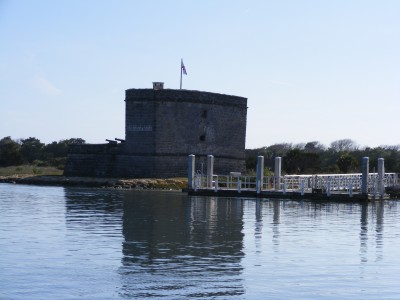
The fog bank that rolled in from the Atlantic Ocean last night stayed with us all morning. We were finally able to weigh anchor after noon o'clock which meant we weren't able to go very far so we anchored in the Matanzas river inlet, in front of the fort, in 13-15 feet of water (s.t.m. 792.4) The current here is strong - running out at 1.6 knots (we're approaching low tide). Neat looking fort (in the picture) but after reading the history - kind of gruesome. Matanzas means slaughter in Spanish and more than 300 French Huguenots were killed where the fort stands in 1565. I guess that a group of them left their settlement somewhere near Jacksonville to attack the Spanish at Saint Augustine. They evidently got lost and shipwrecked here near the inlet and when the Spanish discovered them, on the beach, they demanded that they surrender and renounce their protestant ways (and change to Catholicism). They did surrender but when they refused to renounce their faith, the founder of St Augustine (Pedro Menendez de Aviles) ordered their deaths. They were bound and led behind the sand dunes and all summarily stabbed to death. The fort was then erected sometime after that to guard St Augustine's from further attacks that might come through Matanzas Inlet.
The surf sounds loud from where we're anchored. There's a ferry (free) that runs from across the beach over to the fort. They give a tour of the place and the history (once again gruesome). An osprey flew overhead with a small fish. Is this guy following us? Stay away from our mast and boom. Gorgeous birds...
The surf sounds loud from where we're anchored. There's a ferry (free) that runs from across the beach over to the fort. They give a tour of the place and the history (once again gruesome). An osprey flew overhead with a small fish. Is this guy following us? Stay away from our mast and boom. Gorgeous birds...
Comments
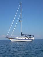
| Vessel Name: | Kolibrie |
| Vessel Make/Model: | Bayfield 36 |
| Hailing Port: | Jackson |
| Crew: | Wayne & Pat |
| About: | Back in Michigan for Hurricane Season 2009... |
| Extra: | Our boat is a Bayfield 36. Not the fastest little thing, but a nice little cruiser that we like to call home. |
| Home Page: | www.kolibrie.us |
Gallery not available
Great Lakes to The Bahamas
Who: Wayne & Pat
Port: Jackson