The First Mate's Journal
Where to next?
Great Lakes to The Bahamas
Who: Wayne & Pat
Port: Jackson
Favorites
05 November 2009 | Deltaville, VA
16 October 2009 | Deltaville, VA
27 May 2009 | Deltaville
26 May 2009 | Deltaville
25 May 2009 | Deltaville
24 May 2009 | Fishing Bay (N37*32.418 W76*20.203) to Deltaville
23 May 2009 | Great Bridge VA (N36*43.285 W76*14.508) to Fishing Bay VA (N37*32.418 W76*20.203)
22 May 2009 | Buck Island, NC (N36*16.034 W75*57.520) to Great BridgeVA (N36*43.285 W76*14.508)
21 May 2009 | The Alligator River Bridge, NC (N35*53.847 W76*02.024) to Buck Island, NC (N36*16.034 W75*57.520)
20 May 2009 | Alligator River Bridge, NC
19 May 2009 | Alligator River Swing Bridge, NC
17 May 2009 | The Pungo River, NC (N35*33.715 W76*28.557) to Alligator Swing Bridge, NC (N35*53.874 W76*02.024)
16 May 2009 | Eastham Creek Anchorage NC (N35*17.680 W76*36.514) to The Pungo River, NC (N35*33.715 W76*28.557)
15 May 2009 | Town Creek Marina, Beaufort NC (N34*43.519 W76*39.898) to Eastham Creek, NC (N35*17.680 W76*36.514)
14 May 2009 | Town Creek Marina, Beaufort, NC
13 May 2009 | Taylor Creek, Beaufort, NC (34*42.860 76*39.831) to Town Creek Marina, Beaufort, NC
12 May 2009 | Mile Hammock Bay (N34*33.163 W77*19.528) SM#244.5 to Taylor Creek, Beaufort, NC (34*42.860 76*39.831)
11 May 2009 | Wrightsville Beach NC (N34*12.441 W77*47.965) SM#283.2 to Mile Hammock Bay (N34*33.163 W77*19.528) SM#244.5
10 May 2009 | Shallottes Inlet, NC (N33*54.913)SM330 to Wrightsville Beach Anchorage (N34*12.447 W77*47.953)
09 May 2009 | Bull Creek, SC (N33 36.667 W79 06.228) to Shallottes Inlet, NC (N33*54.913)
Wow Submarines and we're now officially back on US Soil!
04 May 2009 | Fernandina Beach Florida to Charleston, South Carolina

Monday, May 4, 2009
Okay we called in to Customs at 9:15am and are now officially cleared back into the U.S.A. What a difference from clearing in at the Port Huron Customs. This time we weren't made to feel like fugitives - Thank you guys...I hated how the Port Huron guys made us feel like criminals... By the way I mentioned the Horse Latitudes yesterday... Way back in the day of the heavy sailing ships, when the tall ships ruled the seas, they would travel between 4-8 knots in the Atlantic crossings. But when they came into the mid-latitudes between 30-35* either north or south of the equator, the winds became weaker. These areas of weak winds would make a ships progress even slower. If the vessel was becalmed for weeks on end without proper provisions, the horses became the main fare so the crew would not starve. Other tales talk about throwing the horses overboard to lighten the load and save provisions. Either way, the horses were usually the first to go. Hence these areas were called the "Horse Latitudes"
Weather from Fernandina to Altamaha Sound GA looks pretty good for today and tonight. S winds 15 knots, 2-4 ft seas are called for the next few days with only an isolated shower or so.
12:30pm we raised our anchor and headed out of the harbor. As we were leaving we heard a call come in over the radio that a submarine was going to be coming into the St. Mary's Channel (the one we were departing from). Two Coast Guard boats came zooming by us at the same time so we thought it might be one of our subs (the Coast Guard acts as escorts for Naval Vessels). Seeing the Coast Guard reminded me that I needed to call my brother and let him know I was heading out for Charleston so I quickly called him then went on Sub Alert. I've always wanted to go on a working submarine and thought well, I'll at least try and get a picture of one. There's a sub base of some sort as you turn right into the St Mary's River (to Georgia). If you turn left you go to Florida, right you go to Georgia.
We've run into those carnivourous flys that plagued us on Lake Michigan. They've found us here - ouch! These little varmints take chunks out of you! I managed to get some distant shots of the sub and it's pilot ship. It wasn't a Naval Sub but one from Brazil (?). Exciting nonetheless to share a channel with a sub J
At 1600 Otto decided to come apart on us again so when Wayne got back up (1700) we re-McGyvered it with more strapping tape (what a wonderful tape - duct tape wouldn't work in this situation). So we are clipping along at 7.5 knots with Otto again. I've discovered that he steers the boat much better than Wayne or I, but the tape and belt keep separating, and the belt is falling apart. We are led by Strapping Tape...
Spotted another sea turtle again - they are so incredible looking bobbing along the surface with their little yellow heads and they can dive pretty quickly. More dolphins joined us around1800 but I didn't get any pictures of them this time. The waves are building and wave periods shortening. With clouds building on the horizon we decided that it was time to put a reef back in the main. Then decided to put 2 reefs in the main sail. With 2 reefs (shortened sail) we're still clipping along at 6.7 to 7.1 knots in speed.
Comments
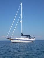
| Vessel Name: | Kolibrie |
| Vessel Make/Model: | Bayfield 36 |
| Hailing Port: | Jackson |
| Crew: | Wayne & Pat |
| About: | Back in Michigan for Hurricane Season 2009... |
| Extra: | Our boat is a Bayfield 36. Not the fastest little thing, but a nice little cruiser that we like to call home. |
| Home Page: | www.kolibrie.us |
Gallery not available
Great Lakes to The Bahamas
Who: Wayne & Pat
Port: Jackson