Sailing with the Andersons
17 May 2015 | Great Barrier Reef
15 May 2015 | Yulara, Australia
10 May 2015 | Dingo Fence North of Coober Pedy
06 May 2015 | Coober Pedy, Australia
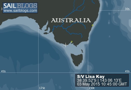
03 May 2015
30 April 2015 | Melbourne, Australia
29 April 2015 | Sydney Harbor, Australia
13 November 2014 | Coral Sea
02 October 2014 | Tanna Island, Vanuatu
28 September 2014 | Mamanuca's, Fiji
25 August 2014 | South Pacific Ocean
12 August 2014 | Kandavu
05 August 2014 | Suva, Fiji
04 August 2014 | Fulaga (Vulaga), Fiji
03 August 2014 | Fulaga (Vulaga), Fiji
22 July 2014 | Fulaga (Vulaga), Fiji
20 July 2014 | Fulaga (Vulaga), Fiji
18 July 2014 | Fulaga (Vulaga), Fiji
17 July 2014 | Fulaga (Vulaga), Fiji
16 July 2014 | Fulaga (Vulaga)
Passage notes: Kadavu to Denerau
25 August 2014 | South Pacific Ocean
Larry Anderson
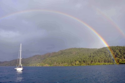
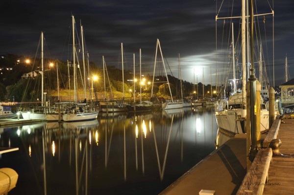
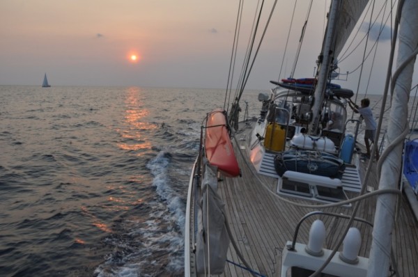
A double rainbow over S/V Alearis
August 25, 2014
From the notes of Larry: Kadavu to Denerau
We've been in Kadavu (pronounced Kandavu) for 13 days now and it's time to move on. The winds have been blowing pretty good for most of our stay here. We've had strong trade winds out of the South East. We are anchored in Nagara bay on the North side of Ono Island. This bay is only open to the North East and should provide good protection from the South East trades. Except it seems that the winds are bending around the island and blowing straight down on us. There is a lot of water "fetch" when the winds come into this bay so the wind waves have a chance to build and make life on the boat a tad uncomfortable. It's blowing 20-25 knots and forecast to pick up over the next few days. So we have to leave now or find a more protected anchorage and hunker down for the next 3 or 4 days at least. Another factor when the winds blow that hard for any length of time is the sea state. The longer the wind blows the higher and steeper the waves become. We found out early on it's usually the seas that get you. We can handle high winds but the waves cause all kinds of other problems.
After a quick crew discussion we vote to weigh anchor tonight. What? Sail out of a reef infested anchorage at night? After calculating the distance to our destination, about 120 nautical miles to Nadi, and figuring our typical boat speed about 7 kts., we should arrive at our destination in 16 hours. Two problems with that. First, we have to be able to sail out of a pass from the island we are on, with reefs between us and the pass. Second, 3 hours before our arrival in Nadi we have to cross a barrier reef and thread our boat thru another pass. Our only option is to leave as late in the afternoon as we can and try not to arrive before sunrise. The charts are so far off in Fiji, and just don't show all the reefs and rocks, therefore you should really only sail between the hours of 9am and 3pm - this is when there is enough light with the sun at a high enough angle that you can actually see the reefs and "bommies" (growths of coral that can pop straight up for 100 feet or more in the middle of nowhere).
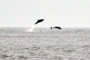
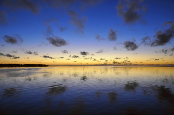
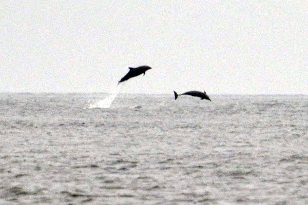
So we pull up the anchor around 3:35pm and start making our way around the island to exit the pass. As we leave we look back and see our good friends on Buena Vista (who left Ventura California in 2009 also) and Alearis. A double rainbow is over their boats. Just as we exit the reef we have dolphins on our bow. What a great sign, good luck I'm thinking.
We are pretty much sailing dead down wind which is kind of hard to do. This requires the jib (the sail in the front) to be on one side of the boat, and the main sail to be on the other side. Ben had helped me rig the spinnaker pole out on the port side of the boat before we left the anchorage (when it's much easier to do). We attach the jib to the end of this pole to hold the sail in position, the only way you can sail dead down wind. Unfortunately I've miscalculated the wind angle and we have the pole on the wrong side of the boat, arghhhhhh! So now we have to wrestle the pole down and reposition it correctly on a heaving deck as the sun is setting. Ben is great and we get the job done and the sails are set.
We watch a beautiful sunset and we can see yet another wildfire on the main island of Kadavu as we pass. Looking ahead on the chart we have to pass between two islands on our way to Nadi. They are Mbengga and Vatulele islands. No problem as I look on the electronic chart plotter. I measure a distance of 26 miles apart. Until I zoom in for more detail. Then I can see their outlying reefs which cut the distance down dramatically. Only 14 miles between the reefs if the chart is acurrate. In addition I see a tiny little island about half way in between the reefs cutting that distance almost in half. No problem I think I still have a little over 3 miles if I pass in between the little island and the fringing reef.
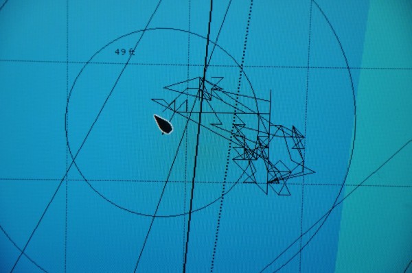
The sun sets and it is one of the darkest night I can remember, no moon and not even a star, just overcast and howling winds, which are starting to increase the farther away from Kadavu we sail. We must be getting out of the islands' wind shadow. As the winds increase so do the height of the waves. But the worst part is the waves are now close together. They have an extremely short period (the distance measured in time from one wave crest to the next). Our boat speed is now passed the 7 knots I calculated our passage on and is fluctuating between 8-10 knots. Lisa Kay is now starting to surf down the waves as they push under the boat. As each wave passes and we balance on the crest the boat starts to yawl back and forth. It's so bad that the compass gyrates back and forth so much it's impossible to tell what course we are actually sailing. The course over ground indicator on the chart plotter has a delay in it as it gets it's information transmitted from half a dozen GPS satellites, that makes it of minimal use. Now I'm thinking about threading the needle between these islands, crap!
But wait the charts show both islands have navigation lights. As we approach where I think we should be seeing them I don't. It's still pitch black. The waves keep building and now as each wave passes under the the stern the bow dips down at an incredible angle. I keep thinking, if we were sailing onto one of those reefs and a breaking wave was pushing the boat, this is exactly what it would feel like. The waves are passing by now with such force and breaking on both sides of the boat it does feel like we're in the surf line. But we're not, yet I can see a dull glow from the lights on shore on the mainland reflecting off the clouds to my right. Now I can really tell how much the boat is yawling on top of each wave.
Short of being able to tell our actual course I start watching the "cross track error" or "XTE" readout on our GPS. This handy measurement shows how far to the left or right you are from your intended course. It's also fluctuating wildly, but if I note the reading every few minutes I can tell the trend. Are we moving farther off our course? To the port or starboard? I start making small incremental corrections to the auto pilot and anxiously watch the XTE to see if the number increases or decreases. In between checks I'm trying to not focus on the breaking waves going off on both sides of the boat every few seconds. I'm trying to remember my Coastal Navigation class at Olympic Circle Sailing Club in Berkeley. I'm pretty sure they never touched on this. I'll speak with them about this if we survive :).
I'm watching the depth gage as well, trying to use as many different sources to narrow down our exact location and direction. It's no help, it only measures to 300 feet and we are in over 2000 feet of water. The edge of the reefs go from about 1800 feet to the edge of the reef very quickly. The radar is sweeping the 385 meter rise on Mbengga and also showing Vatulele as a good return, however the boat is yawling so violently that with every sweep of the radar both islands move dramatically on the screen. No help.
We carry on, I am afraid to let Ben start his shift so I do a double. Finally the chart plotter is showing our tiny boat (there are no big boats on the ocean) has cleared the pass between the two islands and the reefs. I start to breath a sigh of relief. We are still moving way too fast but in order to reef the main we would have to disconnect the jib from the spinnaker pole and turn the boat head on into these nasty breaking seas. I tell Ben when we get to the next pass before dawn we'll just heave to and wait for sunrise. Goodnight........
Lisa wakes me before dawn as a 600 foot freighter is heading straight for us. He wants to go in the same pass we are heading for. But that is another story.
August 25, 2014
From the notes of Larry: Kadavu to Denerau
We've been in Kadavu (pronounced Kandavu) for 13 days now and it's time to move on. The winds have been blowing pretty good for most of our stay here. We've had strong trade winds out of the South East. We are anchored in Nagara bay on the North side of Ono Island. This bay is only open to the North East and should provide good protection from the South East trades. Except it seems that the winds are bending around the island and blowing straight down on us. There is a lot of water "fetch" when the winds come into this bay so the wind waves have a chance to build and make life on the boat a tad uncomfortable. It's blowing 20-25 knots and forecast to pick up over the next few days. So we have to leave now or find a more protected anchorage and hunker down for the next 3 or 4 days at least. Another factor when the winds blow that hard for any length of time is the sea state. The longer the wind blows the higher and steeper the waves become. We found out early on it's usually the seas that get you. We can handle high winds but the waves cause all kinds of other problems.
After a quick crew discussion we vote to weigh anchor tonight. What? Sail out of a reef infested anchorage at night? After calculating the distance to our destination, about 120 nautical miles to Nadi, and figuring our typical boat speed about 7 kts., we should arrive at our destination in 16 hours. Two problems with that. First, we have to be able to sail out of a pass from the island we are on, with reefs between us and the pass. Second, 3 hours before our arrival in Nadi we have to cross a barrier reef and thread our boat thru another pass. Our only option is to leave as late in the afternoon as we can and try not to arrive before sunrise. The charts are so far off in Fiji, and just don't show all the reefs and rocks, therefore you should really only sail between the hours of 9am and 3pm - this is when there is enough light with the sun at a high enough angle that you can actually see the reefs and "bommies" (growths of coral that can pop straight up for 100 feet or more in the middle of nowhere).
So we pull up the anchor around 3:35pm and start making our way around the island to exit the pass. As we leave we look back and see our good friends on Buena Vista (who left Ventura California in 2009 also) and Alearis. A double rainbow is over their boats. Just as we exit the reef we have dolphins on our bow. What a great sign, good luck I'm thinking.
We are pretty much sailing dead down wind which is kind of hard to do. This requires the jib (the sail in the front) to be on one side of the boat, and the main sail to be on the other side. Ben had helped me rig the spinnaker pole out on the port side of the boat before we left the anchorage (when it's much easier to do). We attach the jib to the end of this pole to hold the sail in position, the only way you can sail dead down wind. Unfortunately I've miscalculated the wind angle and we have the pole on the wrong side of the boat, arghhhhhh! So now we have to wrestle the pole down and reposition it correctly on a heaving deck as the sun is setting. Ben is great and we get the job done and the sails are set.
We watch a beautiful sunset and we can see yet another wildfire on the main island of Kadavu as we pass. Looking ahead on the chart we have to pass between two islands on our way to Nadi. They are Mbengga and Vatulele islands. No problem as I look on the electronic chart plotter. I measure a distance of 26 miles apart. Until I zoom in for more detail. Then I can see their outlying reefs which cut the distance down dramatically. Only 14 miles between the reefs if the chart is acurrate. In addition I see a tiny little island about half way in between the reefs cutting that distance almost in half. No problem I think I still have a little over 3 miles if I pass in between the little island and the fringing reef.
The sun sets and it is one of the darkest night I can remember, no moon and not even a star, just overcast and howling winds, which are starting to increase the farther away from Kadavu we sail. We must be getting out of the islands' wind shadow. As the winds increase so do the height of the waves. But the worst part is the waves are now close together. They have an extremely short period (the distance measured in time from one wave crest to the next). Our boat speed is now passed the 7 knots I calculated our passage on and is fluctuating between 8-10 knots. Lisa Kay is now starting to surf down the waves as they push under the boat. As each wave passes and we balance on the crest the boat starts to yawl back and forth. It's so bad that the compass gyrates back and forth so much it's impossible to tell what course we are actually sailing. The course over ground indicator on the chart plotter has a delay in it as it gets it's information transmitted from half a dozen GPS satellites, that makes it of minimal use. Now I'm thinking about threading the needle between these islands, crap!
But wait the charts show both islands have navigation lights. As we approach where I think we should be seeing them I don't. It's still pitch black. The waves keep building and now as each wave passes under the the stern the bow dips down at an incredible angle. I keep thinking, if we were sailing onto one of those reefs and a breaking wave was pushing the boat, this is exactly what it would feel like. The waves are passing by now with such force and breaking on both sides of the boat it does feel like we're in the surf line. But we're not, yet I can see a dull glow from the lights on shore on the mainland reflecting off the clouds to my right. Now I can really tell how much the boat is yawling on top of each wave.
Short of being able to tell our actual course I start watching the "cross track error" or "XTE" readout on our GPS. This handy measurement shows how far to the left or right you are from your intended course. It's also fluctuating wildly, but if I note the reading every few minutes I can tell the trend. Are we moving farther off our course? To the port or starboard? I start making small incremental corrections to the auto pilot and anxiously watch the XTE to see if the number increases or decreases. In between checks I'm trying to not focus on the breaking waves going off on both sides of the boat every few seconds. I'm trying to remember my Coastal Navigation class at Olympic Circle Sailing Club in Berkeley. I'm pretty sure they never touched on this. I'll speak with them about this if we survive :).
I'm watching the depth gage as well, trying to use as many different sources to narrow down our exact location and direction. It's no help, it only measures to 300 feet and we are in over 2000 feet of water. The edge of the reefs go from about 1800 feet to the edge of the reef very quickly. The radar is sweeping the 385 meter rise on Mbengga and also showing Vatulele as a good return, however the boat is yawling so violently that with every sweep of the radar both islands move dramatically on the screen. No help.
We carry on, I am afraid to let Ben start his shift so I do a double. Finally the chart plotter is showing our tiny boat (there are no big boats on the ocean) has cleared the pass between the two islands and the reefs. I start to breath a sigh of relief. We are still moving way too fast but in order to reef the main we would have to disconnect the jib from the spinnaker pole and turn the boat head on into these nasty breaking seas. I tell Ben when we get to the next pass before dawn we'll just heave to and wait for sunrise. Goodnight........
Lisa wakes me before dawn as a 600 foot freighter is heading straight for us. He wants to go in the same pass we are heading for. But that is another story.
Comments
| Vessel Name: | Lisa Kay |
| Vessel Make/Model: | Tayana 55 Cutter Rigged Sloop |
| Hailing Port: | San Francisco |
| Crew: | Larry, Lisa & Ben |
| About: | |
| Home Page: | http://www.sailblogs.com/member/lisakay/ |
Lisa Kay's Photos - Main
 |
 |
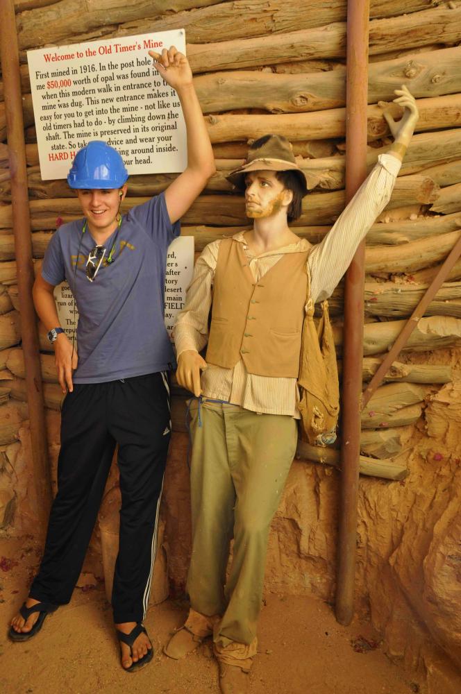 |
Tour of an underground hotel, opal mine and an underground church.
27 Photos
Created 6 May 2015
|
 |
 |
 |
 |
 |
 |
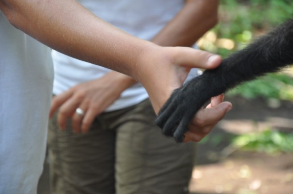
This gallery goes with "They Like White Meat Don't They?"
23 Photos
Created 29 October 2012
|
 |
 |
 |
 |
 |
 |
Misc shots of our Carnival experience in Panama City, Panama.
34 Photos
Created 24 March 2012
|
 |
Photos of our trip into the Darien province of Panama.
90 Photos
Created 21 February 2012
|
 |
 |
 |
 |
 |
 |
Halloween at Marina Papagayo and moving to Bahia Ballena
20 Photos
Created 13 November 2011
|
 |
 |
Shots selected by Ben of his time in Costa Rica
38 Photos
Created 21 September 2011
|
 |
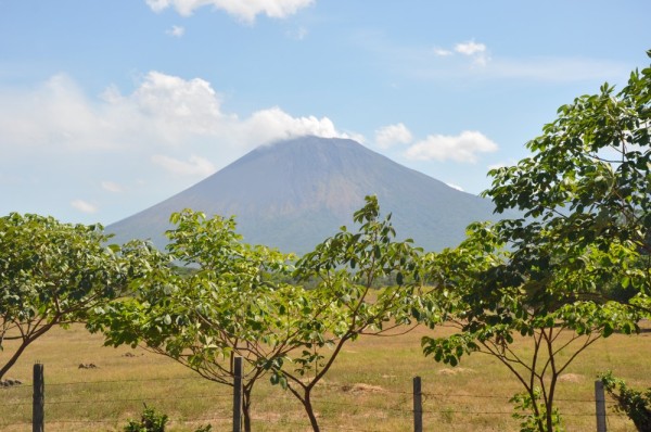 |
Our trip to the capitol city of Managua, Masaya Volcano, Granada, Mombacho Volcano, Puenta Teonoste, and a zipline adventure.
56 Photos
Created 10 June 2011
|
 |
Our sailing into Nicaragua then hiking and surfing Cerro Negro Volcano!!!
34 Photos
Created 10 June 2011
|
 |
 |
These are shots of our inland trip to an Eco Lodge at the Mayan ruins near Paleque, 2 waterfalls, and a trip through Sumidero Canyon.
53 Photos
Created 6 June 2011
|
 |
 |
S/V Lisa Kay
Who: Larry, Lisa & Ben
Port: San Francisco
Gallery