
MangoandMe
14 December 2012
30 June 2012 | ASCENSION ISLAND
30 June 2012 | ASCENSION ISLAND
04 June 2012
28 May 2012 | St Helena, South Atlantic Ocean
28 May 2012 | St Helena, South Atlantic Ocean
25 May 2012 | Riviera Beach, Florida
23 May 2012 | Riviera Marina, Riviera Beach FL
23 May 2012 | Riviera Beach Marina, Riviera Beach, Florida
21 May 2012 | En route to Riviera Beach, Florida
20 May 2012 | En route to Riviera Beach, Florida
19 May 2012 | En route to Riviera Beach, Florida
18 May 2012 | En route to Riviera Beach, Florida
17 May 2012 | En route to Riviera Beach, Florida
16 May 2012 | En route to Riviera Beach, Florida
15 May 2012 | En route to Riviera Beach, Florida
14 May 2012 | En route to Florida
13 May 2012 | Destination:Riviera Beach Marina, Riviera Beach, Florida
12 May 2012 | Destination:Florida
11 May 2012 | On the way to the Caribbean
CAIRNS TO THE TIP OF AUSTRALIA(video)
31 July 2011
david
AT THE TOP, finally
30 July 2011 | Mt Adolphus Island in the Torres Strait
david
AT THE TOP, finally. Today, as I dropped the anchor at Mt Adolphus Island, the first leg of my voyage back to the USA ended. After approximately 1500 miles up the east coast of Australia with numerous stops, some in very questionable anchorages and, for the most part, in strong winds, we have finally reached the 'TOP'. Many a time was repeated in my head the words of a colleague of mine who completed a circumnavigation with his wife last month. "Dave" he said, "the fun part is over... from here west, its all work". Gosh, I hope he's not completely right but so far...
We are now in the Torres Strait, a unique place in the world as it is the coincidence between two great oceans: in effect the Pacific from the east ends here and the Indian Ocean in effect begins here. At same time two big land masses, Papua New Guinea in the north and Australia in the south are separated by a mere 75 miles making this one of the great natural 'funnels' of the world. The trade winds are perhaps the strongest and most prolonged found anywhere on the globe and the currents in this narrow space of water can move up to 6 knots.
Everything changes at this point. I transition from coastal sailing to open ocean sailing. Upon setting out from Mt Adolphus and with a little bit of luck my first stop will be Christmas Island - over 2000 miles of open water. At that point, I will be officially in the middle of the Indian Ocean. Im always awed by those kind of water distances and, to tell you the truth, can never quite get 'my mind around it' until Im there.
Shearwater seems strong and ready, all systems are functioning well and as for me, well, I learnt some good lessons here on the east coast of Australia leading me to a deeper understanding, indeed respect, for Shearwater's powers.
More from the Torres Strait in the next days.
SOMETIMES ONE GOES WITH THE GUT
29 July 2011 | Bushy Islets off the East Coast of Australia
david
Ok, so after all that handwringing I shared with you as to 'what to do', finally, I 'went with the gut' and did none of them.
230 AM: the alarm sounds, dutifully I got out of bed ready for the 90 mile dash, only to find ...its raining. Lord...add that to this already complicated mix! Went back to bed.
7 AM: winds had lessened a little, rain had stopped - quickly put all in gear, hauled up the anchor and sailed away....but to where?
Hadnt decided yet. I knew that there were two little 'islets' about 40 miles to the north. But the book said: "...secure but thoroughly miserable anchorage". Hmmm thats not good. Ok, well then lets sail right by and have a look. Five hours later...sailed right by, had a look and...well, it wasnt that bad - didnt seem any worse than some of the others - threw the anchor down - 25 knots wind - it held and here I am hoping that come first light tomorrow, I am as approving of my gut as I am now.
Incidentally, we have only 50 miles to the top of Australia!
A NAVIGATIONAL QUANDRY
27 July 2011
david
Tonight finds me in Margaret Bay, wide, pretty... anything but peaceful. Yes, we are now, once again, under a 'strong wind warning' - the incessant force against the boat at anchor confirms that description.
Here's the quandry. They are predicting this 'strong wind' for the next 4 days. Do I sit here in this maelstrom or, do I keep going? But, the next anchorage is 90 miles from here...a long day at high speeds. But even more to the point, if one doesnt make that anchorage by dark, then one must keep going all night - coming into an unknown anchorage in pitch black is for me, not an option. Ironically, this high wind would be the very ticket to getting to this anchorage in one day - Shearwater is more than enthusiastic. With lower winds I might be forced to do an intermediate stop - the only option being an 'up the river' deal and... we dont like that.
And to add to the considerations - this anchorage, Mt Adolphus, is the last and final one before the launch of the next leg and points west. That makes it even more imperative to be able to make it in the light, stop, rest study, particularly the weather, before continuing on through the current ridden Torres Straits, into the Arafura Sea and finally, the Indian Ocean. So there you have it...perhaps a sleepless night for me. Any ideas?
AN "OUTPOST OF CIVILIZATION"
26 July 2011
david
Heading into the Northern Territory, it really feels like the frontier here. Since leaving Cairns, I have not seen a single human on shore. But tonight, Im anchored in a bay and directly ahead of me on shore are about 5 houses in varying states of disrepair-and, the first humans since Cairns! It is described as follows: " An outpost of civilization...200 miles north of Cairns...two public coin and card operated STD phones...towards the old dock is the Kennedy Memorial(?)a picnic shelter and a pit toilet." Well there you have it...at least a good toilet!
THE LONE COCONUT TREE
25 July 2011 | Morris Island, a tiny coral cay on the East Coast of Australia
david
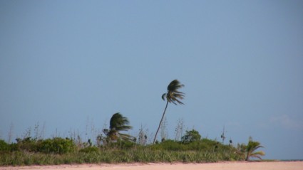
For days now I have been anticipating this stop - 'Isolated atoll, blue water, tiny spit of land with some scrub, fine sand, one grave and...ONE COCONUT TREE'! A famous coconut tree, so famous that it has now been included on the official map of this area titled and numbered..."Australian Chart 834". This must be the only coconut tree to have ever attained such status and... well, after all, rightly deserved considering its 'against all odds' sort of thing on this tiny spit of land.
So today as I approached starting at about 2pm I eagerly sought the horizon and the small island....nothing. But, then at around 3 pm outlines started to etch into the endless expanse, there it was, the atoll, low lying, barely a few feet above sea level. But where was that coconut tree? Simply couldnt see it....then almost suddenly, as though to defend its charted status, there it was, leaned over from centuries of winds from the east, and yes, all alone. I was in awe as I approached and as we got closer so did the windswept profile of that lone coconut tree with its withered trunk. But I had things to do, so I tore my thoughts away from the reverie, put the anchor down, breathed a great sigh of relief and... immediately returned to the coconut tree, this time gazing upon it from its other side. And then horror struck, NO! It couldnt be. I was aghast, after all this anticipation, all this wonderment, this admiration, there, seemingly nestling up against its leaning trunk was... ANOTHER COCONUT TREE! Im going to call the Australians!
So today as I approached starting at about 2pm I eagerly sought the horizon and the small island....nothing. But, then at around 3 pm outlines started to etch into the endless expanse, there it was, the atoll, low lying, barely a few feet above sea level. But where was that coconut tree? Simply couldnt see it....then almost suddenly, as though to defend its charted status, there it was, leaned over from centuries of winds from the east, and yes, all alone. I was in awe as I approached and as we got closer so did the windswept profile of that lone coconut tree with its withered trunk. But I had things to do, so I tore my thoughts away from the reverie, put the anchor down, breathed a great sigh of relief and... immediately returned to the coconut tree, this time gazing upon it from its other side. And then horror struck, NO! It couldnt be. I was aghast, after all this anticipation, all this wonderment, this admiration, there, seemingly nestling up against its leaning trunk was... ANOTHER COCONUT TREE! Im going to call the Australians!
| Vessel Name: | Shearwater |
| Vessel Make/Model: | CONSER 47 Racer/Cruiser Catamaran |
| Hailing Port: | West Palm Beach Florida |
| Crew: | MANGO AND ME |
| About: | |
| Extra: | Shearwater is a 47 foot, very sleek and light catamaran. She is part of a fleet of 11 that were built - its a sister ship of Shearwater that holds the unofficial speed record. 31 knots! Of the this fleet, only one has flipped...so we are on the side of good odds! |
Gallery not available
Who: MANGO AND ME
Port: West Palm Beach Florida
Favorites
- A11.TO SOUTH AFRICA-LURKING LOWS!
- A10. COCOS KEELING-INDIAN OCEAN-MAURITIUS
- 9. AUSTRALIA - OVER THE TOP TO CHRISTMAS
- 8. AUSTRALIA'S EAST COAST
- 7. FIJI TO AUSTRALIA
- SHEARWATER - THE CATAMARAN
- 6. RANGIROA/TAHITI/PALMERSTON
- 5. TO THE MARQUESAS - NUKU HIVA
- 4. PANAMA/GALAPAGOS
- 3. KUNA INDIANS/PANAMA CANAL
- 2. JAMAICA/CARTAGENA
- 1. FLORIDA/BAHAMAS/CUBA
- Show All Posts