MOONBEAM: Circumnavigation 2013 - 2015
MOONBEAM INFO
Who: Capt Ken and Lil Bardon
Port: Marco Island, FL, USA
POSTS
FAVORITE LINKS
SAILING SCHEDULE 2015
FEB-MAR - Thailand, get boat ready for shipping to the Med
APR - boat in Marmaris, Turkey
MAY - sail from Turkey to Crete
JUNE - sail the Greek Isles, thru the Corinth Canal and up the Adriatic
JUL-OCT - Croatia, Italy, France, Monaco, Spain, Gibraltar
OCT-NOV - cross the Atlantic to BVI’s
NOV - Thanksgiving in the BVI’s
DEC - ?????
___________________________________
SAILING SCHEDULE 2014
EARLY APRIL: depart New Zealand for Brisbane, Australia
MID APRIL - EARLY JULY cruise North towards Cairns along the Great Barrier Reef
JULY - OCTOBER cruise islands of Indonesia to Bali
MID OCTOBER - NOVEMBER sail from Bali to Thailand with a stop on Singapore
___________________________________
SAILING 2013
JAN 13 - depart Marco Island for Panama
MAR 11 - Panama - Marquesas
LATE APR - Marquesas - Tahiti
MID MAY - Cruise Pacific Islands
MID JUN/JUL/AUG - Tahiti - Fiji via Cook, Samoa, Tonga Islands
MID AUG - Cruise Fiji Islands
MID SEPT - Fiji - New Zealand
OCT INTO 2014 - Moonbeam in New Zealand
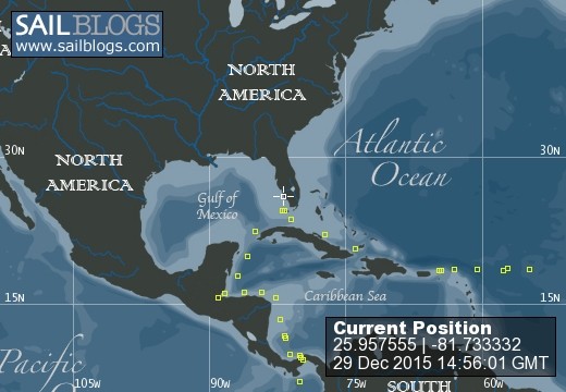
29 December 2015 | MARCO ISLAND
13 December 2015 | MARCO ISLAND, FLORIDA
11 December 2015 | KEY WEST, FLORIDA. USA (YEAH)
11 December 2015 | KEYWEST, FL
10 December 2015 | APPROACHING KEY WEST
08 December 2015 | SAILING THE NORTH COAST OF CUBA
07 December 2015 | APPROACHING THE EAST END OF CUBA
05 December 2015 | LEAVING LUPERON, DR
03 December 2015 | APPROACHING PUERTO PLATA, DOMINICAN REPUBLIC
01 December 2015 | ROAD TOWN, BVI
30 November 2015 | ROAD TOWN, TORTOLA, BVI
27 November 2015 | LEVERICK BAY, VIRGIN GORDA
23 November 2015 | 18 30'N:64 23'W, VIRGIN GORDA. BVI'S
21 November 2015 | 18 36'N:62 59'W, 75 MILES TO VIRGIN GORDA
20 November 2015 | 18 34'N:60 23'W, 220 MILES TO VIRGIN GORDA
19 November 2015 | 18 28'N:57 35'W, APPROACHING THE ISLANDS
18 November 2015 | 18 32'N:54 43'W, APPROACHING THE ISLANDS
16 November 2015 | 18 44'N:49 54'W, APPROACHING THE ISLANDS
15 November 2015 | 18 24'N:47 06'W, APPROACHING THE ISLANDS
14 November 2015 | 18 15'N:44 26'W, SOMEWHERE IN THE NORTH ATLANTIC
RUNNING OUT OF (BLOG) STEAM
11 October 2015 | BENALMÁDENA, ESPAÑA
LIL

As you may have noticed, my blogs are getting a little light (or lite) since, besides our recent paparazzi experience, we're basically just taking care of the business of readying the boat for the next leg, and meeting up with local friends. Faithful Moonbeam followers that you may be, you're probably not all that interested in which restaurant at the marina has the best cheeseburger with sautéed onions. (If you are, you can email me and I'll provide that important info.)
So...since it is a rainy day today (one of three all summer), and a perfect day for blog-writing, I thought I'd give you a run-down of where we've been. Over the past two and a half years, on several occasions, I've updated the blog site with Moonbeam's route. Those map pictures were taken from the Rand McNally 4' X 3 ' world map which currently adorns our dining room table at home, while the Bardon Bed and Bistro is closed for the season.
However, most Americans have never thought about this (nor had I before the odyssey started): American style world maps are all about us. When I bought one and got ready to chart Moonbeam's passage from Florida, south to and through the Panama Canal, and across the Pacific, it quickly became apparent to me that in no time at all, Moonbeam and crew would be falling off the end of the earth (map). I did a little (old-fashioned) cut and paste (with scissors and tape....yep...they still make that stuff), split the map in half, and then re-taped the two ends together, so the passage would take center stage. That worked very well....until now.
I can plot this summer's Med adventure...but once Moonbeam and crew leave the straits of Gibraltar, they will, once again face the same 'dropping off the face of the earth (map)' situation as they head west across the Atlantic. I guess that is why they make globes. I have a few more weeks to figure out that solution...but I'm thinking of contributing to Barnes and Noble's continued existence by buying another map and pasting just the 'Spain to the east coast of the U.S.' part onto the western side. Stay tuned.
Meanwhile, my rainy day activity for today (cookies are all baked and Atlantic crossing meals are prepared) was to chart out this summer's trip. The pink line highlights Moonbeam's trip from the time I joined Ken in Chania, Greece, through the Greek Isles, north to Croatia, south to Montenegro, across to Italy, around the boot, up to Rome, across to Sardinia, Menorca, Mallorca, to Barcelona, and then past Ibiza and west and south along the Spanish coast until we arrived here in Benalmádena. (Whew...I'm exhausted just reliving it,) The green line highlights our road trips. We rented cars in Croatia, Montenegro, Italy, Menorca, Mallorca, Spain and Andorra.
You may be wondering why we picked the places we did, and by-passed others. First of all, it's a boat...a sailboat...which by definition means that we don't make huge distances, and we have to plan out our time and travel carefully to be where we need to be to join up with crew and..stay within the good weather windows, where possible. Secondly, we have already been to many of the places we by-passed. Several years ago, before Moonbeam hit the high seas, we had the pleasure of cruising with our dear buddies, Bob and Mina, on their sailboat, and we spent time then on the east coast of Italy, Croatia, Crete, Malta and Sicily. Not that these aren't places to revisit but...it's a big world out there..and and our ages, we need to be somewhat selective as to how we spend our time. Finally, we did want the trip to meet the desires of our visiting crew, so to some extent, we wanted to organize the trip around their interests.
This probably sounds like my last hurrah...but it isn't. As the risk of boring myself and you, I will try to update the blog for the next few weeks while I'm here. Then, I'll pass the torch (iPad notes) to a new generation of blog updaters: the crazy cronies who will join Captain Ken for the transatlantic crossing. Those of you who are the 'real boaters' will get what will probably interests you more: the 'real deal' of circumnavigation and life at sea.
Comments
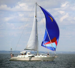
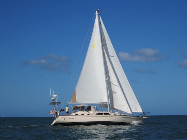
| Vessel Name: | Moonbeam |
| Vessel Make/Model: | Island Packet 485 |
| Hailing Port: | Marco Island, FL, USA |
| Crew: | Capt Ken and Lil Bardon |
Moonbeam's Photos - Main
.jpg) |
 |
MOONBEAM INFO
Who: Capt Ken and Lil Bardon
Port: Marco Island, FL, USA
POSTS
FAVORITE LINKS
SAILING SCHEDULE 2015
FEB-MAR - Thailand, get boat ready for shipping to the Med
APR - boat in Marmaris, Turkey
MAY - sail from Turkey to Crete
JUNE - sail the Greek Isles, thru the Corinth Canal and up the Adriatic
JUL-OCT - Croatia, Italy, France, Monaco, Spain, Gibraltar
OCT-NOV - cross the Atlantic to BVI’s
NOV - Thanksgiving in the BVI’s
DEC - ?????
___________________________________
SAILING SCHEDULE 2014
EARLY APRIL: depart New Zealand for Brisbane, Australia
MID APRIL - EARLY JULY cruise North towards Cairns along the Great Barrier Reef
JULY - OCTOBER cruise islands of Indonesia to Bali
MID OCTOBER - NOVEMBER sail from Bali to Thailand with a stop on Singapore
___________________________________
SAILING 2013
JAN 13 - depart Marco Island for Panama
MAR 11 - Panama - Marquesas
LATE APR - Marquesas - Tahiti
MID MAY - Cruise Pacific Islands
MID JUN/JUL/AUG - Tahiti - Fiji via Cook, Samoa, Tonga Islands
MID AUG - Cruise Fiji Islands
MID SEPT - Fiji - New Zealand
OCT INTO 2014 - Moonbeam in New Zealand
FEB-MAR - Thailand, get boat ready for shipping to the Med
APR - boat in Marmaris, Turkey
MAY - sail from Turkey to Crete
JUNE - sail the Greek Isles, thru the Corinth Canal and up the Adriatic
JUL-OCT - Croatia, Italy, France, Monaco, Spain, Gibraltar
OCT-NOV - cross the Atlantic to BVI’s
NOV - Thanksgiving in the BVI’s
DEC - ?????
___________________________________
SAILING SCHEDULE 2014
EARLY APRIL: depart New Zealand for Brisbane, Australia
MID APRIL - EARLY JULY cruise North towards Cairns along the Great Barrier Reef
JULY - OCTOBER cruise islands of Indonesia to Bali
MID OCTOBER - NOVEMBER sail from Bali to Thailand with a stop on Singapore
___________________________________
SAILING 2013
JAN 13 - depart Marco Island for Panama
MAR 11 - Panama - Marquesas
LATE APR - Marquesas - Tahiti
MID MAY - Cruise Pacific Islands
MID JUN/JUL/AUG - Tahiti - Fiji via Cook, Samoa, Tonga Islands
MID AUG - Cruise Fiji Islands
MID SEPT - Fiji - New Zealand
OCT INTO 2014 - Moonbeam in New Zealand