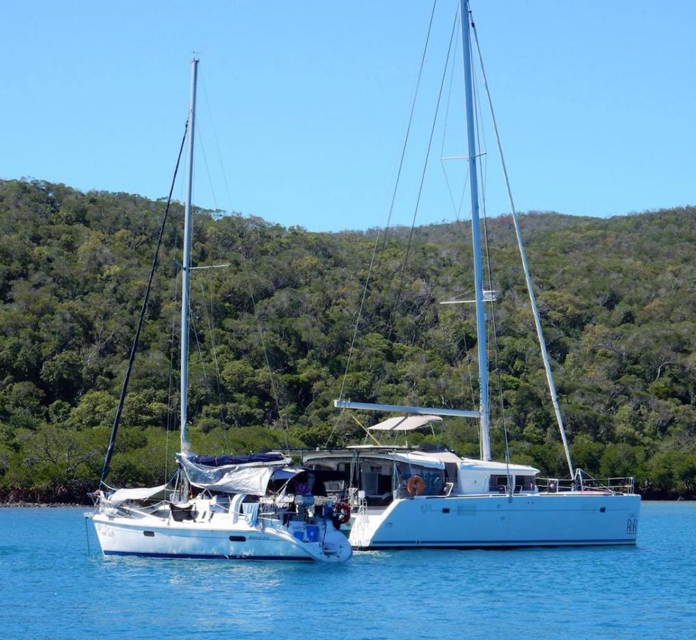
Lagoon 450 Moor R&R Kathryn Roper & Paul Rogers
Incorporating the world famous photo series East Coast Australian Walks "Paul did not do" plus the much rarer "See Paul Walk" series of photos. Although two photos hardly a series make. As for grammar, spelling and punctuation (Forgetaboutit)
09 January 2019
05 January 2019
28 December 2018
24 December 2018
21 December 2018
19 December 2018
15 December 2018
11 December 2018
08 December 2018
03 December 2018
27 November 2018
17 November 2018
15 November 2018
14 November 2018
11 November 2018
30 October 2018
22 October 2018
12 October 2018
09 October 2018
30 September 2018
Here comes the Rain.
29 March 2017
Been raining in Brisbane area since late yesterday evening so far 30 to 80 mm have fallen.
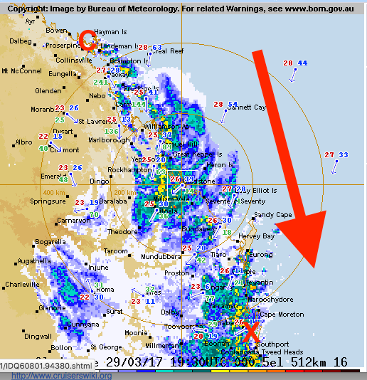
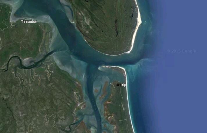
Current Rain Radar image tells the story of the progress of ex tropical Cyclone Debbie.
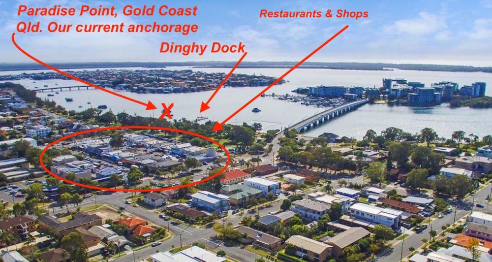
"C" at the top of map marks the point of landfall on Oz mainland. That is aprox 900 km NNW (550 miles) of point "X" where we currently are. The whole system is traveling in the direction of the arrow. So probably in for another 24 to 36 hours of rain.
BOM Forecast
At 4am EST Ex-Tropical Cyclone Debbie was located over inland central Queensland just south of Emerald. The system is expected to continue moving southeastwards over the Central Highlands this morning, before tracking over southeast Queensland during Thursday afternoon.
Impacts:
Ex-Tropical Cyclone Debbie will continue to generate areas of very heavy rain over the Capricornia, Southern parts of the Central Highlands and Coalfields, Wide Bay and Burnett and parts of the Darling Downs and Granite belt and Southeast Coast districts. Currently the heaviest rainfall is occurring over much of the Capricornia and Wide Bay and Burnett region, and parts of the Southeast Coast district.
Widespread daily rainfall totals of 150 to 250mm are expected (thats 6 to 10 inchs) a day for my non-metricated readers), with significantly higher accumulations possible locally. This rainfall will likely be very intense at times, leading to a risk of severe localised flash flooding.
Locations that may be affected include Rockhampton, Gladstone, Kingaroy, Bundaberg, Miles and the Sunshine Coast.
The focus for heavy rain will then shift south and extend into southeastern parts of the state during Thursday afternoon. Widespread daily rainfall totals in excess of are 200mm (10 inches) possible, with isolated very heavy daily totals in excess of 400mm (16 inches) possible, mostly around the higher ground in southeast Queensland.
Looks like we are not doing a lot for the next couple of days.
Current Rain Radar image tells the story of the progress of ex tropical Cyclone Debbie.
"C" at the top of map marks the point of landfall on Oz mainland. That is aprox 900 km NNW (550 miles) of point "X" where we currently are. The whole system is traveling in the direction of the arrow. So probably in for another 24 to 36 hours of rain.
BOM Forecast
At 4am EST Ex-Tropical Cyclone Debbie was located over inland central Queensland just south of Emerald. The system is expected to continue moving southeastwards over the Central Highlands this morning, before tracking over southeast Queensland during Thursday afternoon.
Impacts:
Ex-Tropical Cyclone Debbie will continue to generate areas of very heavy rain over the Capricornia, Southern parts of the Central Highlands and Coalfields, Wide Bay and Burnett and parts of the Darling Downs and Granite belt and Southeast Coast districts. Currently the heaviest rainfall is occurring over much of the Capricornia and Wide Bay and Burnett region, and parts of the Southeast Coast district.
Widespread daily rainfall totals of 150 to 250mm are expected (thats 6 to 10 inchs) a day for my non-metricated readers), with significantly higher accumulations possible locally. This rainfall will likely be very intense at times, leading to a risk of severe localised flash flooding.
Locations that may be affected include Rockhampton, Gladstone, Kingaroy, Bundaberg, Miles and the Sunshine Coast.
The focus for heavy rain will then shift south and extend into southeastern parts of the state during Thursday afternoon. Widespread daily rainfall totals in excess of are 200mm (10 inches) possible, with isolated very heavy daily totals in excess of 400mm (16 inches) possible, mostly around the higher ground in southeast Queensland.
Looks like we are not doing a lot for the next couple of days.
Comments
| Vessel Name: | Moor R&R |
| Vessel Make/Model: | Lagoon 450 2013 |
| Hailing Port: | Wherever the Boat is anchored is Home. |
| Crew: | Kathryn Roper, Paul Rogers, Mo and Omah (Cat Cats). |
| About: | Mo (Black cat) and Omar (White cat) Moor R&R (Fat cat) Kathy and Paul cleaners, repairers and feeders. |
| Extra: | One Glass of Red wine = 1 hour in the Gym no wonder I am so fit. |
Moor R&R's Photos - Main
 |
 |
 |
 |
 |
 |
 |
 |
 |
 |
 |
 |
 |
 |
 |
 |
 |
 |
 |
 |
 |
 |
 |
 |
 |
 |
 |
 |
 |
 |
 |
 |
 |
 |
 |
 |
 |
 |
 |
 |
 |
 |
 |
 |
 |
.JPG) |
 |
 |
 |
.jpg) |
 |
 |
 |
 |
 |
 |
 |
 |
 |
 |
 |
 |
 |
 |
 |
 |
 |
 |
 |
.JPG) |
 |
 |
 |
 |
 |
 |
 |
 |
 |
 |
 |
 |
 |
 |
 |
 |
 |
Southern Moreton Bay Islands
6 Photos
Created 14 October 2014
|
 |
Leaving Cleveland for the Start
3 Photos
Created 14 October 2014
|
 |
River Fire Brisbane from QPAT reception
11 Photos
Created 14 October 2014
|
 |
 |
 |
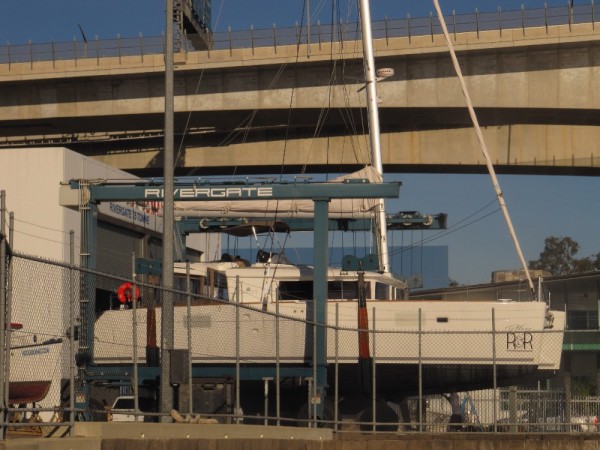 |
Haul out for Water maker , bow sprite, solar panels and new anti foul paint at Brisbane's Rivergate Marina and Shipyard
6 Photos
Created 23 June 2014
|
 |
 |
Moor R&R Lagoon 450

Who: Kathryn Roper, Paul Rogers, Mo and Omah (Cat Cats).
Port: Wherever the Boat is anchored is Home.
Gallery