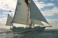
Dermot's NW Passage voyage on board Young Larry
23 September 2010 | Just left Nome
23 September 2010 | Just left Nome
17 September 2010 | Approaching Nome
12 September 2010 | Barrow
11 September 2010 | 25 miles east of Point Barrow
11 September 2010 | 25 miles east of Point Barrow
10 September 2010 | Beaufort Sea
09 September 2010 | Beaufort Sea
08 September 2010 | Approaching Demarcation Point
07 September 2010 | Herschel Island
06 September 2010 | Herschel Island
05 September 2010 | The rather splendidly named Beluga Bay- despite its absence of said whales so far
05 September 2010
04 September 2010
04 September 2010 | Tuktoyaktuk
03 September 2010 | Approaching Tuktoyaktuk
02 September 2010 | Franklin Bay
02 September 2010 | Franklin Bay
02 September 2010 | Franklin Bay
01 September 2010
US of A, here we come
08 September 2010 | Approaching Demarcation Point
Liz for Dermot
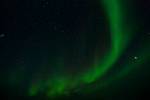
After supper last night cottage pie and whilst I was blogging (all cooked one pan at a time by Maire on the diesel stove to save gas) Sibeal noticed that the Northern Lights were starting up. She was very keen to get a photo (or a few dozen) of them. In order to do so you need a long exposure time and the movement of the boat even at anchor will blur the picture.
For the photo nerds out there, the trick seems to be to put up the ISO speed setting to about 1,600. Set the camera somewhere steady, preferably on a tripod. Use a wide-angle lens, at a wide aperture of 4.5 and an exposure time of 30 seconds with a remote release or timer so there is no wobble pressing the shutter release, and then experiment.
She and I went ashore after midnight to wait and to experiment. By the time we got ashore they had faded a bit but this gave us time to get set up. I was sure I had packed a mini-tripod but I haven't been able to find it. As a result we set up our cameras on a sheet of polystyrene. I balanced my camera on the loaded rifle! It was quite disturbing to think that there could be a bear out there. When walking with the crew of Ariel IV that day, Sibeal had come across very clear ice bear tracks on the beach on the other side of the bay. One suspects that a bear would be much better at spotting us than we would him! To start with I couldn't make my camera do what I wanted it to, but I found an obscure bit of its menu choice and it worked. I hope you like the results! Note Jupiter shining brightly in the picture too.
It was gone 2am before we were back on the boat. Nevertheless Andrew, Maire and I (but not Sibeal!) were up early to finish off the gaff and rig the sail. It does look great and is effectively a near identical replacement. There was also a fair bit of tidying up to do after all the work. I have to say we could not have had a better place to do it than Herschel Island. It was midday before we were weighing (and washing) a very muddy anchor.
We could have aimed for an anchorage just inside the USA/Alaska border but would have arrived at about 2am. For this reason, and because time is marching on (I have to be back on call at work and Young Larry has almost 2,000 miles to cover to Kodiak before winter proper arrives) we decided to press directly onto Point Barrow, about 400 miles away.
There isn't really much between here and there. There is the giant oil refinery at Prudhoe Bay but it is possibly too shallow for us and they really don't welcome the likes of us in yachts.
The winds have eased away to become light and variable. There is some conflict between various forecasts, but it is likely that we could have a day or two of headwinds to slow us down, before it veers (a clockwise change in direction) into a more favourable NE direction. We hope.
We are currently motoring along the last of the Yukon coast before we get to Alaska. An impressively high mountainous area, with ranges of 7-9,00 foot mountains inland. Looking at the chart, it is amusing to see that the British mountains straddle the Canada/USA border.
The border runs due north. Cheekily, the Americans then claim territorial waters perpendicular to the coast, rather than continuing northwards towards the North Pole. This leaves a disputed wedge shaped stretch of sea and sea-bed. The whole issue of sovereignty of the ocean bed stretching towards the pole is highly contentious, especially as it gets more accessible with global warming. Russia, USA, Canada, Denmark (through Greenland) and Norway are all in the chase for potential mineral and oil rights. The Chinese even think they should have a say along the lines of the way that Antarctica was declared a global resource!
We have had a look at the Canadian and US ice charts- we prefer the Canadian ones. There is a band of ice close to the Alaska shore that has been pretty static doe sometime. The centre of it is old 7/10ths ice with thinner 2/10th around the outside. There is potentially a passage inside it but the distance we would save going that way, as opposed to going over the top and north of the ice, isn't that great. In addition we really don't fancy the thought of negotiating even 2/10ths ice in the longer hours of proper darkness that we now experience. Accordingly we have set a course to go the slightly long way round.
We heard on the radio schedule that Ariel IV are staying in Demarcation Bay which is apparently fabulous. A shame to miss it but I am sure we are doing the right thing.
We also heard about the progress of some other boats. There is a New Zealander doing the NW Passage single-handed and non-stop in a boat called Astral Express. One has to ask oneself why one would want to miss out on all the fabulous places that we have stopped off at. Presumably it is another "record" to aim for but from my point of view would be a shame.
In addition the motor-less Norwegian trimaran is currently in the lead for the combined attempt to be the first to do NE and NW passages in one season. They are going the other way to us and have recently passed Point Barrow so we might pass them soon.
Best go now. I am cooking and tonight's menu is a novel form of Chilli Con Carne- made with chick peas in the absence of kidney beans.
Comments
| Vessel Name: | Young Larry |
Gallery not available