
Options
17 October 2012 | North Carolina
16 October 2012 | Near Elizabeth City, North Carolina
12 October 2012 | Dismal Swamp, VA-NC
07 October 2012 | Baltimore to Portsmouth, VA
29 August 2012 | Ptown to Edgartown
14 August 2012 | Portland, Maine
13 August 2012 | Freeport, Maine
09 August 2012 | Baltimore to Portsmouth, NH
05 July 2012
07 May 2012 | Cape Hatteras to Norfolk
04 May 2012 | East of Georgia?
03 May 2012 | Stuart, FL
06 January 2012
27 August 2011 | BWI Airport
24 August 2011
21 August 2011 | Now in Delaware City
20 August 2011 | Long Island Sound
13 August 2011 | Newport to Cuttyhunk to Vineyard Haven
13 August 2011 | BI, RI
07 August 2011 | Vineyard Haven, Martha's Vineyard
Sunny Skies
17 October 2012 | North Carolina
David
After large doses of wind, rain and clouds from Baltimore to Elizabeth City, we were more than ready to see the sun again. Tuesday was spent fixing the rudders under gloomy, spitting skies. On Wednesday morning, we resumed our trip south, past Elizabeth City and out into Albemarle Sound. As Wednesday wore on and we entered the Alligator River, the sun returned and changed our cool and cloudy day into a pleasantly warm one. We anchored for the night just short of the Alligator River canal, with a couple of hours to enjoy the afternoon and watch the sunset. With no clouds to be underlit by the setting sun, it was a "blue sunset".
With only 30 nautical miles to Belhaven on Thursday, we slept in a little and got going about an hour after sunrise. Another sunny day! As we made our way down the canal, we were baffled by the mysterious beast swimming across the river. It was too long to be a fowl or a beaver. As we closed the distance, we realized we were seeing the head and spine of a deer! We did not see a single alligator, though.
It didn't take long before the first of many power boats flew by us. Almost all of them slowed down to pass us, which was polite of them. In some cases, though, it's actually better when they go by at full speed, with their hulls planing across the top of the water. Then again, there are the big "Sportfisher" boats that were apparently designed to move more water more violently than any other boat ever built. Sportfishers produce the biggest wakes at all speeds. They accomplish this by having very wide, deep and heavy butts that they drag through the water, with their bows pointing towards the sky. The only thing I can think is that these characteristics were part of the Sportfisher design criteria.
Brooke and I explored Belhaven on bikes and were a little saddened by the experience. Clearly, it is a town that was once prosperous. Many of the stately homes along the waterfront are gone or dilapidated. We counted about 20 nice homes remaining and 20 in dire need of repair and as many vacant lots. Likewise, the downtown business district was largely deserted. We decided to bike to the Food Lion, which was over a mile away from downtown along a busy highway. That's where all the commercial development has gone. We finished the day with a huge and tasty meal at the Fish Hook, one of the few establishments remaining downtown. Both Tim and I woke up in the middle of the night, reeling from too much food!
Friday, we were off to Oriental. There was a little fog as we got going, but it quickly burned off, giving us another glorious day. We decided to go off the beaten path: Instead of following the parade of boats down the Intercoastal Waterway, we sailed out towards Pamlico Sound. While this added an hour or so to our journey, it allowed us to relax at the wheel, with no obstructions to avoid, no boats to dodge, no huge wakes to curse at, and, best of all, no danger of going aground by straying a little from the middle of the canal. Our esteemed crewman, Otto the Pilot, did all the steering for us.
We docked at Oriental Marina and Inn and were very pleased all around--friendly people, great accommodations and a very popular Tiki Bar. It was undoubtedly an exaggeration, but we were told Oriental is a town of 900 people and 3000 sailboats.
Brooke and I went on a beautiful walk through the town and along the shore. The only snag was finding a nautically-themed store on Main St. which had too many things we liked. The store owners appreciated our business.
We were curious about how Oriental got its name. We found out that, when one of the boring founding fathers thought to call it Smithville, his more clever wife suggested "Oriental," after the name she had seen on a wrecked ship.
We drove to New Bern on Saturday for lunch with Russell Adams, a friend and experienced sailor who has logged many miles aboard Options. As we were leaving town, we noticed an endless stream of people parking far away from downtown and walking a mile or more across a long bridge. They were heading to the New Bern Mum Festival, which attracts a quarter million or so unfortunate souls each year. We were not impressed. We did see a few mums, but mostly it reeked of fried food and was heavily congested. It seemed like all 250,000 people were packed into a few city blocks.
With over a mile to walk back to the car, Brooke's sandal strap broke. I was able to snag some clear packing tape from one of the vendors. I taped the sandal to Brooke's foot in a secure and not unattractive manner. With all the boat problems we've had, I think I'm getting better at improvising temporary fixes!
How to Use a Truck to Fix Your Boat
16 October 2012 | Near Elizabeth City, North Carolina
David - another wet day
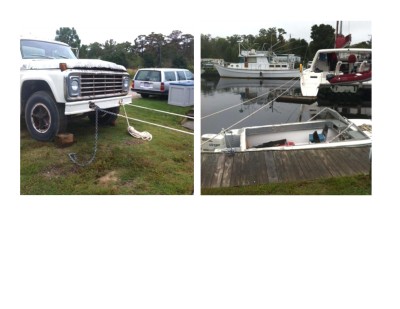
In our last installment, Options suffered a tremendous blow to her port-side rudder, temporarily losing steering. That was last Monday. When we got to Lambs Marina, we shared our problem and Mr. Lamb arranged for a diver and all-around fix-it guy to come first thing Tuesday morning.
Michael Mayo II dove on the rudder and confirmed we had a bent rudder. Mike cheated by using a light to shine through the tobacco-colored water to make his determination. He found that our biggest problem was that the bottom of the rudder had been shoved backwards and was scraping hard on the back bottom of the boat when the rudder was turned through the middle. Miraculously, Mike also had a way to fix the boat without pulling it out of the water to drop the rudder out. This is where the truck comes in!
Mike described a thick, strong padded belt that he would wrap around the lower part of the rudder and connect to a long chain. The chain would be led across the harbor in front of Options and attached to a piling. Ropes would then be led from Options' port-side cleats across the harbor in back of Options and attached to the marina's fuel truck, which apparently had rings mounted on its front bumper just for this purpose!
Options was docked on its starboard side to the marina's fuel dock. To keep Options from moving laterally, Tim and I tied eight or so dock lines from Options' cleats to as many fuel dock pilings. We unwrapped a 250 foot spare anchor line and tied it between the truck's bumper and two port-side cleats. We tugged and tugged until those lines were as tight as we could make them (Tim and I had sore backs that night to remind us how hard we had tugged!). Mike had already dropped chain onto the bottom of the harbor from just beneath the rudder all the way to the dock about 50 feet in front of Options. Mike and his Dad, Michael Mayo I, rigged up a "come along" between the piling and the chain.
Let me pause here. Apparently, every guy in the world knows what a "come along" is. I had never heard of it. Tim explained to me that it was invented during the Civil War to help move field artillery around. With the repeated movement of a short cranking arm, it allows you to tighten a chain by a very small fraction. It took hundreds of cranks to tighten the chain! Here's a link if you want to see the exact 3-ton model they used: http://www.buy.com/prod/3-ton-lever-block-chain-hoist-come-along/227962439.html?listingId=231196327
It took Mike a while to rig the belt to the rudder with a rope to hold it in place. Then, Mike's father, Michael Mayo I, and Mr. Lamb alternated between two come alongs to make the chain tighter and tighter. Mike was under the boat, checking the gap between the boat and the rudder as all the ropes to the truck got very tight. My job was to hold onto a line that Mike would tug on when the gap was right and then I would call out to the "come-along team" to stop. We stopped several times before Mike was satisfied that we had it just tight enough to bend the rudder back without breaking the boat. I was nervous!
Once the padded belt and chain were removed, I gave the wheel a try. You could still feel the rudder rubbing as it turned through the middle, but you could push the wheel through that rough patch with much less force. We were back in business!
Dismal Swamp vs. Options
12 October 2012 | Dismal Swamp, VA-NC
David
Monday morning, Tim and I were up early and had Options underway at 6:25, a good 40 minutes before sunrise. Coming out of Ocean Marine Yacht Center in Portsmouth, Virginia, into the Elizabeth River's south channel, it was very disorienting: There were lights all around, but no depth perception in the black of night. I could see the bows of ships ahead, but was unsure on which side of the ships the channel led. My best guess was wrong, but I was saved by the electronic chartplotter--a GPS for boats. The confusion continued for the next 25 minutes until enough of the coming sunlight made our surroundings more evident.
As we have done twice before, we arrived at the Gilmerton bridge in Portsmouth more than a half hour before its scheduled opening at 7:30 am--I always overestimate the distance and time required to motor from the marina to the bridge! We were at the first lock of the Dismal Swamp by 8 am, in plenty of time for the first opening at 8:30. Once through the lock, we were again amazed at the beauty of the canal stretching to infinity with both overhanging trees and the sky prefectly reflected. On the other hand, the water is eerily brown, the color of tea or coffee--the result of leaves decaying to form tannic acid.
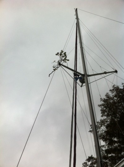
There are dangers lurking in the Dismal Swamp. There are big and small chunks of wood floating at or just below the surface. Some are large enough to do considerable damage. Should you move to one side of the canal to dodge a log, you risk hitting the overhanging branches. We not only managed to do just that, but we also captured a trophy--see the accompanying photo.
Rather than race through the canal as in past years and then hurry up and wait at the next lock, we motored slowly, though still arrived 45 minutes before the 1:30 lock opening. For those in a hurry, this is not the route you want to take. We averaged under 5 miles an hour from the time we left the marina until 2 pm, when we cleared the drawbridge just beyond the second lock!
Once free of the canal and its locks and bridges, we accelerated to a breathtaking 6 knots, or about 7 miles an hour, which is cruising speed with one engine. Running both engines adds less than 2 miles per hour, so we settle for 80% of two-engine speed while consuming half as much diesel.
We picked up the Pasquotank River coming out of the Dismal Swamp canal. It winds around, almost in circles, so that you never know what direction you many be going. For the first several miles, the river is barely wider than the canal--then it widens out to several hundred feet wide. It was at that point that near-disaster struck.
We were keeping wide of the green marker, as the cruising guide suggested, and were in 19 feet of water when the boat hit something very hard--it seemed to lift the boat up and twist us to starboard. It seemed we had lost our ability to steer--the wheel wouldn't budge! After a few minutes, we confirmed that both engines were OK. When we tried to move forward, we circled, doing perfect donuts. We tried to steer using the engines, which almost worked, if you don't mind backing up a lot.
Our rudders were stuck! We suspected a branch had become wedged between one of the rudders and the boat, making the rudders immovable. We had to find out what the problem was. It was 4 pm, so we still had plenty of daylight. The water was as dark brown as could be--you couldn't see anything below the surface!
Since the water was cold and the only wet suit on board fit yours truly, you can guess who was elected to dive under the boat to check the rudders. After running my hands around the tops of both sides of both rudders, I discovered nothing--there were no stuck branches. It occurred to me to use my legs to kick the rudders sideways. I was able to get the starboard rudder to move a little in both directions. The port rudder was more stubborn, but after harder and harder kicks, it finally came loose. We then discovered that we could turn the wheel, although it took a strong effort using both arms to get the rudder past a point just to starboard of the middle.
Once back on board with the anchor stowed, we motored successfully to Lambs Marina, a few miles outside of Elizabeth City. We were safe for the night, but the boat was not in suitable shape for a long journey. Stay tuned…
P.S. Note the trophy that Options is clutching up high on the port side.
As we have done twice before, we arrived at the Gilmerton bridge in Portsmouth more than a half hour before its scheduled opening at 7:30 am--I always overestimate the distance and time required to motor from the marina to the bridge! We were at the first lock of the Dismal Swamp by 8 am, in plenty of time for the first opening at 8:30. Once through the lock, we were again amazed at the beauty of the canal stretching to infinity with both overhanging trees and the sky prefectly reflected. On the other hand, the water is eerily brown, the color of tea or coffee--the result of leaves decaying to form tannic acid.
There are dangers lurking in the Dismal Swamp. There are big and small chunks of wood floating at or just below the surface. Some are large enough to do considerable damage. Should you move to one side of the canal to dodge a log, you risk hitting the overhanging branches. We not only managed to do just that, but we also captured a trophy--see the accompanying photo.
Rather than race through the canal as in past years and then hurry up and wait at the next lock, we motored slowly, though still arrived 45 minutes before the 1:30 lock opening. For those in a hurry, this is not the route you want to take. We averaged under 5 miles an hour from the time we left the marina until 2 pm, when we cleared the drawbridge just beyond the second lock!
Once free of the canal and its locks and bridges, we accelerated to a breathtaking 6 knots, or about 7 miles an hour, which is cruising speed with one engine. Running both engines adds less than 2 miles per hour, so we settle for 80% of two-engine speed while consuming half as much diesel.
We picked up the Pasquotank River coming out of the Dismal Swamp canal. It winds around, almost in circles, so that you never know what direction you many be going. For the first several miles, the river is barely wider than the canal--then it widens out to several hundred feet wide. It was at that point that near-disaster struck.
We were keeping wide of the green marker, as the cruising guide suggested, and were in 19 feet of water when the boat hit something very hard--it seemed to lift the boat up and twist us to starboard. It seemed we had lost our ability to steer--the wheel wouldn't budge! After a few minutes, we confirmed that both engines were OK. When we tried to move forward, we circled, doing perfect donuts. We tried to steer using the engines, which almost worked, if you don't mind backing up a lot.
Our rudders were stuck! We suspected a branch had become wedged between one of the rudders and the boat, making the rudders immovable. We had to find out what the problem was. It was 4 pm, so we still had plenty of daylight. The water was as dark brown as could be--you couldn't see anything below the surface!
Since the water was cold and the only wet suit on board fit yours truly, you can guess who was elected to dive under the boat to check the rudders. After running my hands around the tops of both sides of both rudders, I discovered nothing--there were no stuck branches. It occurred to me to use my legs to kick the rudders sideways. I was able to get the starboard rudder to move a little in both directions. The port rudder was more stubborn, but after harder and harder kicks, it finally came loose. We then discovered that we could turn the wheel, although it took a strong effort using both arms to get the rudder past a point just to starboard of the middle.
Once back on board with the anchor stowed, we motored successfully to Lambs Marina, a few miles outside of Elizabeth City. We were safe for the night, but the boat was not in suitable shape for a long journey. Stay tuned…
P.S. Note the trophy that Options is clutching up high on the port side.
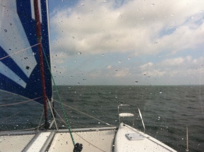
All the Wind You Could Want
07 October 2012 | Baltimore to Portsmouth, VA
David - windy, wet and wild
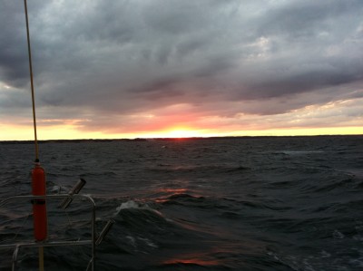
After the "Summer of Our Discontent" due to so little wind for sailing, we've been making up for lost ground this fall. We left Baltimore yesterday around 10am. Starting around 2 pm, we had winds between 20 and 30 knots (23 to 35 mph!) all the way down the Chesapeake Bay, from Annapolis to Norfolk! We wound up flying our jib, a wee handkerchief of a sail, for 18 hours straight! There was a small craft warning in effect, but Options was in her element: flying downwind with two hulls for stability and a big autopilot for control
With that much wind, you get some interesting effects. At first, with the wind coming at us from an angle, we got whacked by the waves. From inside the boat, it sounded and felt like little bombs going off. From outside, the wind was so noisy, you felt the waves rather than heard them. Once the waves lined up a little better with our course, we surfed down the larger ones. As the wind continued to blow, it started moving the water south as well. So not only did we have 20+ knots of winds to send us flying, but we were riding on a moving carpet that added one to three knots of extra speed.
An hour after sunset, it was pitch black, with clouds overhead and no moon yet. The only source of light was the distant glow of the Washington, D.C. metroplex. At 10 pm, the stars came out in wonderful abundance and the moon joined the show about an hour later but, alas, more clouds rolled in before midnight. The only significant source of light remaining was a periodic flash of light over the southern horizon. As we approached Point Lookout at the mouth of the Potomac River, the flashing turned out to be the warning beacon at Brown Point.
Tim took over the night watch shortly after. I went to bed only to discover how cold I was, in spite of two shirts and two layers of fleece. The motion inside our cabin felt like a toboggan negotiating an endless slalom course. Brooke helped me warm up and get to sleep…no, not THAT way--get your mind out of the gutter!. I awoke around 6 am to the sound of heavy rain. I decided to get dressed and lend a hand, as well as place a bowl under our recurring leak. I found poor Ryann (Tim's daughter) wet, cold and shivering at the helm. She was more than ready to call it a night. Tim had been sleeping in the cockpit when the rain sprang its surprise attack. He was equally cold and wet.
As the sun rose, I was amazed to find the strong winds still at work. Apparently, we caught the big winds up north as they formed and rode them all the way south as they filled in. Our timing was flawless! As usual, I will take all the credit for anything that goes right.
We arrived at Ocean Marine Yacht Center in Portsmouth, VA at 9:30 am, a good 4-6 hours earlier than expected, with plenty of time to tie up before the next rain storm blew through. Next up: The StL Cardinals are hosting the Washington Nationals at for Game 1 of the playoffs. Go Cards!
David
P.S. The picture is of the sunset over the western shore of the Chesapeake near Solomon's Island. Pictures never do justice to the size of the waves!
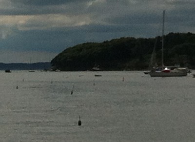
New England Romp
29 August 2012 | Ptown to Edgartown
David - windy
We knew Tuesday morning would be a little wild, with 15-20 knots of wind on our nose and plenty of thunderstorms to add a little excitement. The forecast for the afternoon was much better: Once we got through the Cape Cod Canal, we knew the wind would come from a direction that would let us sail right down to Martha's Vineyard. As things turned out, we were surprised at every turn!
We left Provincetown at 6 am. When we rounded the lighthouse and turned toward our destination, we were hit with the full force of the wind and waves. We were rocking and rolling, but mostly hobby-horsing: The bow was pitching way up and then smacking down with each big wave. That continued for about a half hour and then a little miracle happened. In spite of the 15 knots of wind on our nose, the sea laid itself down and formed a smooth carpet. It made no sense to Tim, Russell or me. We each knew from our sailing experience that wind blowing for 20 hours across 20 miles of open water at 15-20 knots will produce waves of 2-3 feet or more. Instead, we had waves of no more than 1 foot. We still don't understand that.
We watched the radar and saw two large storms that would be crossing our path. As it turned out, the larger of the two storms passed a little to our north as we headed south. The other, more southern storm ran out into the Atlantic before we could catch up with it. After four hours underway, dodging storms, we were amazed that all we had to show for it were a few drops of rain.
My friend Dave Snell is vacationing in Cape Cod this week and suggested I give him a call when Options was going through the Cape Cod Canal so he could bring his family down to see the boat and wave as we went by. Dave's timing was flawless! He pulled into the parking lot just as we were coming down the canal. However, as they got out of the car, the heavens opened up with a drenching downpour. We waved back from under the protection of our bimini and side screens. As soon as we passed, the rain stopped as suddenly as it had started. So much for flawless timing!
The big surprise still awaited us. Tim had been reading one of the cruising guide books to find out more about the Cape Cod Canal Some trivia: It is the widest sea-level canal in the world. The book went on to tell about how rough the waters can be when a strong current is flowing southwest out of the canal and there is a strong wind coming up out of the southwest: Strong wind against strong current can whip up some vicious waves.
As it turned out, we were flying through the canal with 4 knots of current carrying us to the southwest, right into the teeth of a 20 knot southwest wind. Arrghh! After 20,000 miles of cruising aboard Options, I thought I had been through some pretty rough water, but these waves were the worst. We were tossed around like we were in a washing machine. One moment, we we'd be moving at six knots. The next moment, after being bashed in the nose by a wave or two, we were crawling forward at 3 knots. The beating continued for about 30 minutes, until we could get out of the canal, veer away from the wind and lose some of the current.
But there's more. We had wisely reefed the mainsail, seeing 20 knots of wind in the forecast. The first reef reduces the main's sail area by about 20-25% and makes it safe to sail in winds up to 25 knots. We raised sails after exiting the maelstrom and were instantly greeted by 20-25 knots of wind. We had a romp through rough seas, tacking back and forth into the wind because Wood's Hole, our next target, was a little upwind of where we could reach with the sails pulled in tight. There was another sailboat going the same direction, so we of course were racing them. Sad to say, the sailboat, not being a catamaran, was able to sail directly to Wood's Hole without having to tack, and beat us by a mile.
We dropped sail before threading our way through the Wood's Hole channel. This channel can be treacherous, with sideways currents pushing you out of the narrow channel carved through the rocks. Traffic was mercifully light. Between our three pairs of eyes and the chartplotter that shows which direction the boat is actually going (it can be very different than the direction the boat is pointing, due to wind and current), we had an easy time of it.
Coming out of Wood's Hole, we had 20-25 knots of wind on our starboard quarter (i.e., wind coming from the right rear corner of the boat). We unleashed the fabled Code Zero sail, our downwind "screecher" or "gennaker", and took off. In fact, we had so much wind at first, I was worried it was beyond the boat's capacity. The wind must have been squeezed and accelerated as it came through Wood's Hole, but it soon died down to 15-20 knots as we got into the thick of Vineyard Sound. We relaxed and enjoyed a comfortable downwind sail, surfing the waves as they passed under us and dodging the occasional ferry.
As we approached the top of Martha's Vineyard, we spied another sailboat about a mile inshore of us. They also seemed to be headed to Edgartown, so the race was on. We were flying downwind, drawing ever closer. As we approached the final turn towards Edgartown, we were breathing down their necks. We could see the fear in their body language. Then, they cheated! As they made their final turn onto a beam reach (wind coming from the side of the boat), they raised their mainsail and left us in the dust. Raising our main would have required some effort and made no sense for the short distance remaining. So we went 0 for 2 on the racing card for the day.
We had a pleasant evening in Edgartown, hooking up to a mooring around 4 pm and heading in for a walkabout and dinner around 6 pm. Later that evening, Russell was checking the upcoming weather and figured out that we should leave for New York City first thing the Wednesday morning: The forecast showed we could face winds up to 30 knots on the nose if we left as planned on Thursday morning.
David
P.S. The picture is of the downwind romp through Vineyard Sound.
Ode to the Lobstaman
14 August 2012 | Portland, Maine
David
First, a lesson in how to speak "Maine-nese." An example will suffice: "Bar Harbor" is pronounced "Baa Haabaa." A little like "Pawk ya caw in hawvood yawd."
Maine is home to perhaps 10,000 lobstamen (lobstermen, in American English). A typical lobstaman services 400 lobsta traps a day, but his lobsta license allows him to have as many as 880 lobsta traps! Let's go with 400 lobsta traps per lobstaman: That means 4,000,000 lobsta traps in Maine, each with a rope attached to a float on the surface. More about those floats later.
Lobsta traps are 2' x 4' x 18" steel cages that weigh about 50 lbs. and lie in 20 to 150 feet of water. The traps have two entrances with cone-shaped netting that allows the lobsta, with some difficulty, to crawl in to get the bait. To paraphrase Hotel California, "You can crawl in any time you like, but you can never leave!"
On an individual basis, we love, respect and admire the individual lobstaman. They work very hard to bring us a delicious food source. Lobstamen must haul up their 400 50 lb. traps every day, rain or shine, rough or flat seas, calm or high winds. The work is physically demanding, totally exposed to the elements, and, in 2012, not financially rewarding--this year's bumper lobsta crop resulted in depressed prices, settling below $4 a pound!
However, when you combine 10,000 lobstamen, you get a mess. Each one adds more lobsta traps, often right next to the other traps. The surface becomes a maze of floats, each one hoping to be caught in your propeller. Sailing along the Maine coast is like running a gauntlet, dodging float after float, cursing the crazy quilt of lobsta traps!
But wait, there's moah: Over the years, the lobstamen have conspired to develop ever nastier, more evil, more malevolent floats. There are the "peek-a-boo" floats that dive under the water and then pop up for a fleeting second before disappearing again--you don't know whether or not you saw something--should you make a violent turn to avoid the ghostly float or carry on? Then there are the trip-lines: Two or more floats tied together so that, if your propeller goes between them, you will most certainly end up with a rope wrapped around your propeller. This will greatly slow down your boat or stop it altogether. A further development is the "lurker," a float that spends its life just below the surface, but high enough to wrap its rope around your propeller.
So far, we are winning the war in Maine. We have successfully dodged literally thousands of lobsta traps, though it seems like millions. We have not always been so fortunate. In the Florida Keys, we've had our propeller fouled several times by crab traps. The procedure is most unpleasant: Stop the boat, squeeze into a wet suit, attach the snorkel and fins, grab a knife and dive under the boat. I can hold my breath for maybe 30 seconds, just long enough to find the propeller and immediately return to the surface. After several dives, I get a little better, able to make a slash or two on the rope wrapped around the propeller. After about 20 or 30 exhausting dives, the rope comes loose and we can continue on our way.
So far we have really enjoyed Maine, although even Brooke says she has had enough lobsta for a while. Wish us luck the next few days, as we wind our way down the coast of Maine and dodge another thousand or two floats!
David
P.S. The picture shows a section of Maine water that was only moderately crowded with lobster traps. (When the traps are very thick, taking a picture is the last thing on our minds!)
| Vessel Name: | Options |
| Vessel Make/Model: | Admiral 40 |
| Hailing Port: | St. Louis, MO |
| Crew: | David and Brooke Atkinson |
| About: | David and Brooke reside in St. Louis and enjoy sailing (duh!), music, history and traveling. Brooke is a wonderful cook and David is an adequate guitarist. They signed up for an Admiral 38 in 2005. By waiting until 2008 for delivery, they were upgraded to the new Admiral 40. |
| Extra: |
Gallery not available
Options - SA to Carib
Who: David and Brooke Atkinson
Port: St. Louis, MO
See posts below
SailBlogs Friends

