Voyages North
23 July 2023
21 August 2021
11 July 2021 | Posted in Seattle
16 May 2021
07 January 2021
10 April 2020 | Posted in Seattle
31 August 2019 | Posted at Port McNeill
31 August 2019
30 August 2019
30 August 2019 | Posted at Port MCNeill
13 August 2019 | Posted at Prince Rupert
13 August 2019 | Posted at Prince Rupert
03 August 2019 | Posted at Ketchikan
02 August 2019 | Posted at Metlakatla
02 August 2019 | posted in Metlakatla AK
22 July 2019 | Posted at Klawock/Craig
22 July 2019 | Posted at Klawock/Craig
09 July 2019 | Posted at Juneau
09 July 2019 | Posted at Juneau
27 June 2019
Sunday Inlet to Flamingo Inlet. July 31.
17 August 2009 | Flamingo: 52 106.1N, 131 20.9W
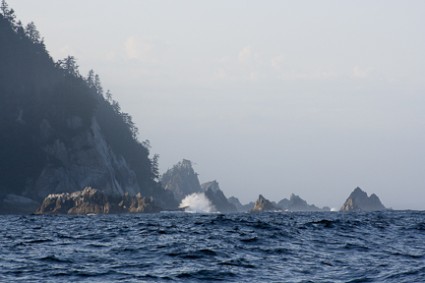
Photo: Pinnacle rocks south of Sunday Inlet
"I just want to get off this coast," I told Steve the next morning when he asked me how far I wanted to go that day. "Northwest gales, 30-40 knots" was still the forecast for the West Coast Queen Charlottes. Was the record stuck at the weather office? We'd learned to sail in the wind and seas but it still made me feel uneasy. And I worried about getting trapped by heavy seas in one of the small inlets.
That day we sailed 40 miles, bypassing Gowgaia Inlet for Flamingo Inlet, 20 miles further. Named for a fishing boat named "Flamingo," rather than the bird, it has the dual advantage of being surveyed and easy to enter. Actual soundings on the chart instead of a blank! Nevermind that they were done with a lead line in 1931.
As we sailed south the mountains became lower, like stairsteps. We rounded the point at the inlet's entrance and sailed into a long narrow bay with rocky shores and green forested hills.
We had read that the beaches in Flamingo are great spots for beachcombing as southern storms blow flotsam and jetsam into the Inlet. We looked for glass balls but all we found was plastic: plastic net floats, nylon fish nets and hundreds of plastic water bottles -- all with their lids screwed on tight. Here on this coast where we hadn't seen another boat or a person for days, the discards of civilization had found us.
Comments
| Vessel Name: | Osprey |
| Vessel Make/Model: | Annapolis 44 sloop |
| Hailing Port: | Seattle |
| Crew: | Steve and Elsie Hulsizer (author of Glaciers, Bears and Totems and Voyages to Windward) |
| About: | |
| Extra: |
Osprey's Photos - Main
No items in this gallery.
Voyages North on SV Osprey
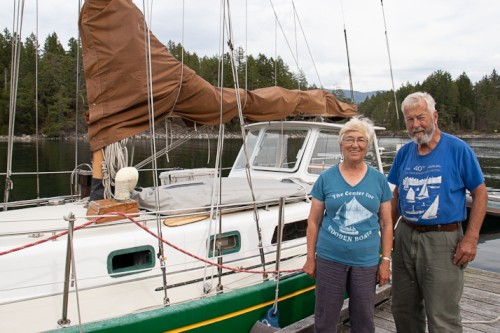
Who: Steve and Elsie Hulsizer (author of Glaciers, Bears and Totems and Voyages to Windward)
Port: Seattle
SailBlogs Friends

