Voyages North
23 July 2023
21 August 2021
11 July 2021 | Posted in Seattle
16 May 2021
07 January 2021
10 April 2020 | Posted in Seattle
31 August 2019 | Posted at Port McNeill
31 August 2019
30 August 2019
30 August 2019 | Posted at Port MCNeill
13 August 2019 | Posted at Prince Rupert
13 August 2019 | Posted at Prince Rupert
03 August 2019 | Posted at Ketchikan
02 August 2019 | Posted at Metlakatla
02 August 2019 | posted in Metlakatla AK
22 July 2019 | Posted at Klawock/Craig
22 July 2019 | Posted at Klawock/Craig
09 July 2019 | Posted at Juneau
09 July 2019 | Posted at Juneau
27 June 2019
Chief Seattle Days coming in August
23 July 2023
Elsie Hulsizer
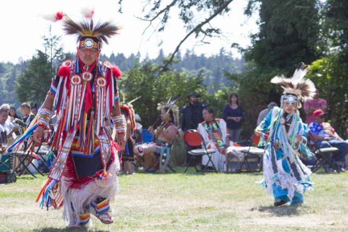
For the first time since the Pandemic the Suquamish Tribe will open their annual Chief Seattle Days event to the general public. Attending one of these events is fun -- and educational.
If you want to know more about what the Chief Seattle Days is all about, read my blog about the 2017 event: 2017 Chief Seattle Days
This year's Chief Seattle Days will be on August 18-20 in the town of Suquamish in Port Madison Bay. It's easy to get to from Seattle (just cross Puget Sound to Port Madison Bay (not to be confused with Port Madison itself on Bainbridge Island) and anchor to the north of the town dock. If there's room on the dock, you can tie your dinghy on the inside and walk ashore. Otherwise, take your dinghy to the beach.
One of the highlights of the event for me was the Gravesite honoring of Chief Seattle which included a recitation from memory of the famous speech by Chief Seattle. I know it's not completely authentic, it was modified by others years after it was given, but just listening to it brought tears to my eyes.
A complete schedule of 2023 events can be found on the Suquamish website.
Around the Hood Canal with Rubber Bands
21 August 2021
Elsie Hulsizer
July 28, 2021
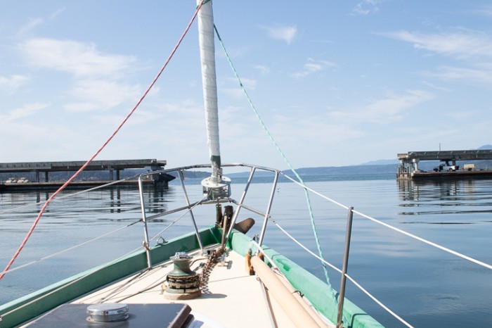
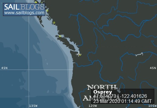
Photo: Osprey going south through the Hood Canal Floating Bridge.
We arrived at the Bridge half an hour early for our requested 1100 hrs opening. When a massive concrete floating bridge was opening just for us, we wanted to be on time.
No simple drawbridge, the Hood Canal Floating Bridge comprises fixed spans (i.e. floating but unmovable) on either end and movable floating spans in between. We had to wait for one of the fixed spans to rise up, making space for one of the movable spans to go underneath it before we could enter the channel.
By 1045, a long line of cars was already waiting for us to get through. At precisely 1100 hrs, the bridge horn blew and the fixed span rose up as the movable span glided east underneath it. When there was enough open water to pass through, Steve shifted to forward and Osprey moved ahead through the opening. I breathed a sigh of relief. Then I looked back. The closed bridge looked so solid, that for an instant I felt trapped. But I shrugged the feeling off; we could always get out by requesting another opening.
With the sun glinting off ripples on the water, Osprey headed south, picking up speed.
Steve and I were taking two weeks to explore the Hood Canal. With the pandemic keeping us out of Canada and Alaska we were looking for someplace new, and hopefully uncrowded, for our next sailing adventure. The Hood Canal promised views of mountains and blue water, sparsely populated shores, a very few marinas, and the nuisance to sailboats of having to open a major bridge to get there.
On the cockpit seat, Chart 18441 (Puget Sound Northern Part) showed large swaths of the north Canal outlined in purple and labeled "Naval Operating Areas." "Operating areas" meant torpedo testing. Steve scanned the water, looking for Navy patrol boats to warn us off. "Maybe they're not operating today," he said. We continued on, passing the Bangor Submarine Base with its bulky buildings and tall antennas. Steve, a former submariner, counted three submarines at the dock.
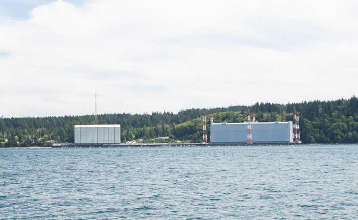
Photo: Bangor Naval Base
To starboard the long thin Tonandos Peninsula divided the Canal into two with Dabob Bay and Quilcene Bay, our destination, on the west. Farther south we could see the broad delta of the Dosewallips River and above it green hills topped with dark mountains, snowless in the summer drought.
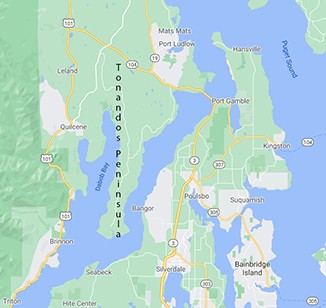
Northern Hood Canal including Dabob and Quilcene Bay
We were motoring around the bottom of the peninsula when Steve muttered, "Something doesn't sound right." He slowed the engine, then shifted into neutral. The engine kept running slowly ahead. Steve shifted into reverse. The engine still ran slowly ahead. He swore. "We have only forward," he said. "No neutral or reverse. I hope I can fix it when we get to Quilcene."
Was this the danger I had anticipated as the bridge had closed behind us? Arranging for repairs in this underpopulated Canal wouldn't be easy. Just then the radio interrupted my imaginations with the call, "Osprey, Osprey." Steve picked up the microphone. It was the Navy calling. They were doing "operations" (testing torpedos) and requested us to go farther north before turning west. We turned north. We weren't going to argue with torpedos.
Once inside Quilcene Bay, we could see a sparsely populated bay with a scattering of houses along the shore, a small marina behind a rock breakwater, and beyond the marina a few industrial buildings. It didn't look like the kind of place that would have yacht repair facilities.
The chart showed a likely anchorage off the marina with depths of from 3-4 fathoms. Our challenge would be to set the anchor without a reverse gear. Steve turned the engine off and we drifted ahead, propelled by momentum. When we were almost stopped, I dropped the anchor, letting enough chain out for a 3 to 1 scope, then setting the brake. The anchor grabbed and brought us to a stop. It had been easy!
By the time I put the anchor hook on the chain and walked aft, Steve had disappeared below. I heard the clatter of stairs being removed from above the engine, then a long silence followed by a string of swear words. Peering into the cabin, I saw Steve holding up a rusty fitting in his hand. "The connector between the gear shift and the cable is broken. I can't fix it and we don't have a spare."
My heart sank as I imagined waiting days for parts to be delivered or, worse, having to pay for a tow out the canal. Steve's thoughts were elsewhere. He was rummaging through the galley drawers. "Where are the rubber bands. I know we've got some."
Finally, Steve held up several blue rubber bands. With a glint in his eyed, he said. "What's that book that Wendy wrote? Around the world with Duct Tape and Bailing Wire?" How about Around the Hood Canal with Rubber Bands?" (He was referring to is Sea Trials: Around the World with Duct Tape and Bailing Wire by Wendy Hinman.)
A half hour later I listened with relief as Steve shifted the engine from forward to neutral to reverse and back. Steve had managed a complicated repair with two rubber bands from a newspaper.
We had a functioning gear shift again. Tomorrow we would explore the Quilcene Marina then head south to Pleasant Harbor. I just hoped the rubber bands would hold.
Photo: Osprey going south through the Hood Canal Floating Bridge.
We arrived at the Bridge half an hour early for our requested 1100 hrs opening. When a massive concrete floating bridge was opening just for us, we wanted to be on time.
No simple drawbridge, the Hood Canal Floating Bridge comprises fixed spans (i.e. floating but unmovable) on either end and movable floating spans in between. We had to wait for one of the fixed spans to rise up, making space for one of the movable spans to go underneath it before we could enter the channel.
By 1045, a long line of cars was already waiting for us to get through. At precisely 1100 hrs, the bridge horn blew and the fixed span rose up as the movable span glided east underneath it. When there was enough open water to pass through, Steve shifted to forward and Osprey moved ahead through the opening. I breathed a sigh of relief. Then I looked back. The closed bridge looked so solid, that for an instant I felt trapped. But I shrugged the feeling off; we could always get out by requesting another opening.
With the sun glinting off ripples on the water, Osprey headed south, picking up speed.
Steve and I were taking two weeks to explore the Hood Canal. With the pandemic keeping us out of Canada and Alaska we were looking for someplace new, and hopefully uncrowded, for our next sailing adventure. The Hood Canal promised views of mountains and blue water, sparsely populated shores, a very few marinas, and the nuisance to sailboats of having to open a major bridge to get there.
On the cockpit seat, Chart 18441 (Puget Sound Northern Part) showed large swaths of the north Canal outlined in purple and labeled "Naval Operating Areas." "Operating areas" meant torpedo testing. Steve scanned the water, looking for Navy patrol boats to warn us off. "Maybe they're not operating today," he said. We continued on, passing the Bangor Submarine Base with its bulky buildings and tall antennas. Steve, a former submariner, counted three submarines at the dock.
Photo: Bangor Naval Base
To starboard the long thin Tonandos Peninsula divided the Canal into two with Dabob Bay and Quilcene Bay, our destination, on the west. Farther south we could see the broad delta of the Dosewallips River and above it green hills topped with dark mountains, snowless in the summer drought.
Northern Hood Canal including Dabob and Quilcene Bay
We were motoring around the bottom of the peninsula when Steve muttered, "Something doesn't sound right." He slowed the engine, then shifted into neutral. The engine kept running slowly ahead. Steve shifted into reverse. The engine still ran slowly ahead. He swore. "We have only forward," he said. "No neutral or reverse. I hope I can fix it when we get to Quilcene."
Was this the danger I had anticipated as the bridge had closed behind us? Arranging for repairs in this underpopulated Canal wouldn't be easy. Just then the radio interrupted my imaginations with the call, "Osprey, Osprey." Steve picked up the microphone. It was the Navy calling. They were doing "operations" (testing torpedos) and requested us to go farther north before turning west. We turned north. We weren't going to argue with torpedos.
Once inside Quilcene Bay, we could see a sparsely populated bay with a scattering of houses along the shore, a small marina behind a rock breakwater, and beyond the marina a few industrial buildings. It didn't look like the kind of place that would have yacht repair facilities.
The chart showed a likely anchorage off the marina with depths of from 3-4 fathoms. Our challenge would be to set the anchor without a reverse gear. Steve turned the engine off and we drifted ahead, propelled by momentum. When we were almost stopped, I dropped the anchor, letting enough chain out for a 3 to 1 scope, then setting the brake. The anchor grabbed and brought us to a stop. It had been easy!
By the time I put the anchor hook on the chain and walked aft, Steve had disappeared below. I heard the clatter of stairs being removed from above the engine, then a long silence followed by a string of swear words. Peering into the cabin, I saw Steve holding up a rusty fitting in his hand. "The connector between the gear shift and the cable is broken. I can't fix it and we don't have a spare."
My heart sank as I imagined waiting days for parts to be delivered or, worse, having to pay for a tow out the canal. Steve's thoughts were elsewhere. He was rummaging through the galley drawers. "Where are the rubber bands. I know we've got some."
Finally, Steve held up several blue rubber bands. With a glint in his eyed, he said. "What's that book that Wendy wrote? Around the world with Duct Tape and Bailing Wire?" How about Around the Hood Canal with Rubber Bands?" (He was referring to is Sea Trials: Around the World with Duct Tape and Bailing Wire by Wendy Hinman.)
A half hour later I listened with relief as Steve shifted the engine from forward to neutral to reverse and back. Steve had managed a complicated repair with two rubber bands from a newspaper.
We had a functioning gear shift again. Tomorrow we would explore the Quilcene Marina then head south to Pleasant Harbor. I just hoped the rubber bands would hold.
Fords Terror: A Convenient Anchorage
11 July 2021 | Posted in Seattle
Elsie Hulsizer
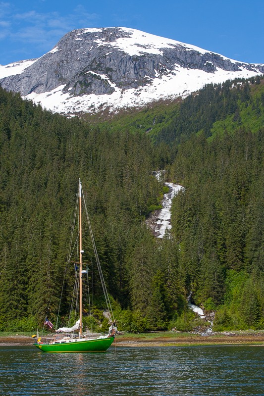
Photo: Osprey anchored in the West Arm of Fords Terror
In April 2013, I wrote an article in 48 North titled Braving the Narrows at Fords Terror. The next time we approached its entrance, we were surprised to see several boats ahead of us waiting for the tide. During previous trips we had seen at most one other boat each time. Concerned that the boaters might not know the safe way to enter, Steve radioed one of them and inquired whether they knew how to get in. "Well, I do have a magazine article about it," the skipper replied. With a full page photo of Osprey anchored in the West Arm of the inlet in the article, he obviously had recognized Osprey. I have since wondered, somewhat guiltily, if my article contributed to an increase in the number of boats going through.
The article is no longer available on the 48 North website. This blog is intended to provide the navigational information it contained. Most of the rest of that story was taken from my book Glaciers, Bears and Totems.
The 2021 edition of the Waggoner Cruising Guide states that there are no convenient anchorages in Endicott Arm, describing Fords Terror, halfway up the inlet, as remote, seldom visited and poorly charted.
I take issue with the characterization of Fords Terror as inconvenient. It's ideally situated for anchoring either the night before or after a trip to Dawes Glacier. And in my opinion, Fords Terror is one of the most spectacular anchorages in Southeast Alaska. It makes a trip up Endicott truly memorable. And although Fords Terror has a challenging entrance with uncharted rocks and no published tide tables, with sufficient local knowledge it's possible to make a trip there safely. And more boats are making it into Fords Terror every year.
In the Third edition of Exploring Southeast Alaska: Dixon Entrance to Skagway, Don Douglass and Reanne Hemingway-Douglas provide a sketch of the Fords Terror entrance and its outer basin. Both the sketch and the U.S. G.S. Survey Map for the Sumdum Quadrangle show more detail than the navigational chart including the locations of shoals and rocks. The Douglasses estimated that the entrance carries 8ft at zero tide and concluded that shallow-draft boats do not have to limit their transit to high-water slack. (The Douglasses successfully entered at low-water slack.) With our 6ft draft keel, we enter only at high-water slack.
There's also a useful trick for entering Fords Terror first reported by Linda Lewis, owner of Private Boating Instruction LLC, in a blog post. Captain Lewis recommended first locating the multi-stream waterfall on the west wall of the outer anchorage, putting your stern on that waterfall, then heading 290 magnetic to the entrance. That course would take a boat into the entrance between the two shoals.
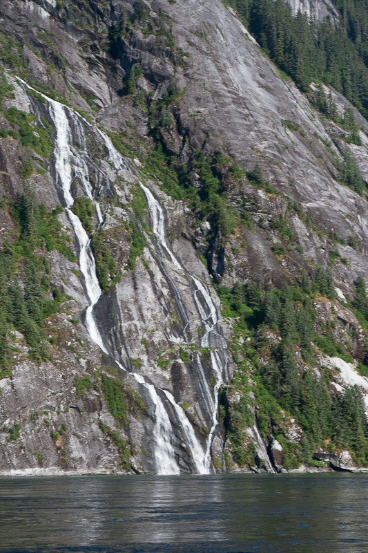
Photo: Multi-stream waterfall for entering Fords Terror
Changes in magnetic variation can alter a compass course over time and enough time has passed since Captain Lewis posted her blog (no longer online) to change the compass course by a few degrees. To deal with this, Steve developed the procedure of setting our course by steering toward the entrance itself from the waterfall, marking our compass course, then following that course into the entrance.
We learned another valuable piece of local knowledge from the tour boat Island Spirit. They enter or leave at 25 minutes after high water at Juneau.
If you are fortunate to arrive outside Fords Terror during low tide, you can observe the rocks and shoals while waiting for the tide to rise. That way, you will not only be able to recognize the entrance, but be properly terrified as you approach it.
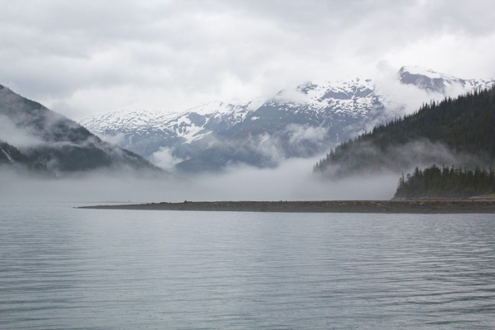
Photo: Fords Terror at Low Tide
In April 2013, I wrote an article in 48 North titled Braving the Narrows at Fords Terror. The next time we approached its entrance, we were surprised to see several boats ahead of us waiting for the tide. During previous trips we had seen at most one other boat each time. Concerned that the boaters might not know the safe way to enter, Steve radioed one of them and inquired whether they knew how to get in. "Well, I do have a magazine article about it," the skipper replied. With a full page photo of Osprey anchored in the West Arm of the inlet in the article, he obviously had recognized Osprey. I have since wondered, somewhat guiltily, if my article contributed to an increase in the number of boats going through.
The article is no longer available on the 48 North website. This blog is intended to provide the navigational information it contained. Most of the rest of that story was taken from my book Glaciers, Bears and Totems.
The 2021 edition of the Waggoner Cruising Guide states that there are no convenient anchorages in Endicott Arm, describing Fords Terror, halfway up the inlet, as remote, seldom visited and poorly charted.
I take issue with the characterization of Fords Terror as inconvenient. It's ideally situated for anchoring either the night before or after a trip to Dawes Glacier. And in my opinion, Fords Terror is one of the most spectacular anchorages in Southeast Alaska. It makes a trip up Endicott truly memorable. And although Fords Terror has a challenging entrance with uncharted rocks and no published tide tables, with sufficient local knowledge it's possible to make a trip there safely. And more boats are making it into Fords Terror every year.
In the Third edition of Exploring Southeast Alaska: Dixon Entrance to Skagway, Don Douglass and Reanne Hemingway-Douglas provide a sketch of the Fords Terror entrance and its outer basin. Both the sketch and the U.S. G.S. Survey Map for the Sumdum Quadrangle show more detail than the navigational chart including the locations of shoals and rocks. The Douglasses estimated that the entrance carries 8ft at zero tide and concluded that shallow-draft boats do not have to limit their transit to high-water slack. (The Douglasses successfully entered at low-water slack.) With our 6ft draft keel, we enter only at high-water slack.
There's also a useful trick for entering Fords Terror first reported by Linda Lewis, owner of Private Boating Instruction LLC, in a blog post. Captain Lewis recommended first locating the multi-stream waterfall on the west wall of the outer anchorage, putting your stern on that waterfall, then heading 290 magnetic to the entrance. That course would take a boat into the entrance between the two shoals.
Photo: Multi-stream waterfall for entering Fords Terror
Changes in magnetic variation can alter a compass course over time and enough time has passed since Captain Lewis posted her blog (no longer online) to change the compass course by a few degrees. To deal with this, Steve developed the procedure of setting our course by steering toward the entrance itself from the waterfall, marking our compass course, then following that course into the entrance.
We learned another valuable piece of local knowledge from the tour boat Island Spirit. They enter or leave at 25 minutes after high water at Juneau.
If you are fortunate to arrive outside Fords Terror during low tide, you can observe the rocks and shoals while waiting for the tide to rise. That way, you will not only be able to recognize the entrance, but be properly terrified as you approach it.
Photo: Fords Terror at Low Tide
| Vessel Name: | Osprey |
| Vessel Make/Model: | Annapolis 44 sloop |
| Hailing Port: | Seattle |
| Crew: | Steve and Elsie Hulsizer (author of Glaciers, Bears and Totems and Voyages to Windward) |
| About: | |
| Extra: |
Osprey's Photos - Main
No items in this gallery.
Voyages North on SV Osprey
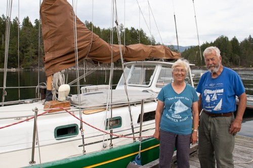
Who: Steve and Elsie Hulsizer (author of Glaciers, Bears and Totems and Voyages to Windward)
Port: Seattle
SailBlogs Friends

