
Voyages of SV Ponderosa
12 October 2012 | Shilshole Bay Marina
10 September 2012 | Port Ludlow
13 August 2012 | Roche Harbor
09 August 2012 | Puget Sound
06 August 2012 | Newport OR
28 July 2012 | Eureka, CA
20 July 2012 | Bodega Bay
16 July 2012 | Port San Luis
15 July 2012 | Santa Barbara
12 July 2012 | Ventura
09 July 2012 | Marina del Rey
07 July 2012 | Mission Bay, Oceanside, Newport Beach
01 July 2012 | San Diego
18 June 2012 | San Diego
16 June 2012 | Turtle Bay to San Diego
12 June 2012 | Turtle Bay
12 June 2012 | Bahia Asuncion'
12 June 2012 | Santa Maria to Abreojos
07 June 2012 | Magdalena Bay to Bahia Santa Maria
03 June 2012 | Cabo San Lucas to Magdalene Bay
2008 North to Alaska - 6
13 October 2009 | Juneau to Glacier Bay to Hoonah AK
Sherry
Missive - 6
June 19, 2008 Cont'd: It felt good to leave the dock, we were ready! We headed north thru Saginaw Channel and the whales wished us goodbye. You can never get enough of watching them. The tourist boats outnumbered the whales by 3 to 1 but at least the folks got their money's worth.
We rounded Mansfield Peninsula to now head south towards our next anchorage in Swanson Harbor. We had sunshine along with patches of fluffy white clouds - dry weather but not hot. Our next body of water was called Icy Strait which would lead us to Glacier Bay. The weather reports never sound good for this area, but heck, what else is new!
The cove was covered with commercial pots and they were strategically placed in the best water depths for anchoring. The rest of the area was littered with rocks and reefs but there was enough area to set anchor comfortably. Once settled we enjoyed the 360 degree view of the mountains, clear skies and birds singing.
Swanson Harbor Air Temp: 60 degrees
Lat: 58.13.153 N Water Temp: 53 degrees
Long: 135.07.860 W Wildlife: whales, eagles
Nautical Miles: 28 Hours: 5
June 20, 2008: We woke to sunshine, and enjoyed our morning coffee while watching dolphins circling our boat. A dinghy ride, fishing and crabbing were on the agenda for the day. Nothing like turkey wings and bacon fat to lure the hungry crabs to our pots; we were set for the big killing.
This probably goes in the records books for the perfect Alaskan day - clear skies, warm temperatures, no wind and flat water. We puttered around the small islands surrounding our anchor area which is part of Point Couverden. Icy Strait was dead calm and you could hear and see the whales blowing a mile away. Dolphins and seals swam around us keeping me entertained while Bob jigged for halibut. The songs of the birds were quite something - one sounded like a car alarm going off. No kidding ... the eagle call is much more pleasant than this bird.
To the west you could see the peaks of Glacier Bay rising majestically to the heavens. Imagine a dozen Mt Rainiers or Mt Bakers all lined up in a row and that view just begins to describe the beauty.
We hit the jackpot on crab at least in quantity, 10 in one and 12 in another pot. Between the two we had 4 keepers. Dinner was fresh crab! The horse flies and no-see-ums were out in full force. I swear they run in shifts, the flies were pesky though dinner and once the evening cooled down, the no-see-ums were on duty. The evening was once again beautiful and quiet. It's hard to go to bed since this was such a rare evening with long daylight hours.
June 21, 2008: Mother Nature is once again fickle and changed back to rain and clouds. We were going to fish our way to Pleasant Island today and stay the night which places us about halfway to Barlett Cove, the park headquarters. But winds predicted out of the east were to pick up to 20 knots and the anchor area is not well protected so we decided to stay put. We are only 38 miles out so we will just have a longer travel day tomorrow.
We got another 3 crab this morning ... a crab quiche is sounding good to me. The refrigerator is running just fine and keeping all the ice we bought solid. It was rather pleasant to have ice cubes in our lemonade. Sounds silly, I know, but ice cubes are a real treat.
All night the wind blew making this place a rough anchorage too. It was rock-a-bye baby all evening long. So much for a peaceful night of sleep ... not when you have dreams of the anchor slipping along the bottom and you wake up to a nightmare of being stuck firmly to shore or drifting out to sea!
June 22, 2008: Although sleep deprived it was time to get a move on to the grandeur of Glacier Bay. The waters in Icy Strait were relatively calm (short choppy waves) and it was warm enough to only wear 3 layers of clothes instead of 4; making progress aren't we! Pt Aldolphus just across Icy Strait from the entrance to the park hosted a whale party ... a total feeding frenzy by a least a dozen humpbacks. What a sight to see, whales everywhere participating in the bubble netting and the sea lions were right in the middle of the action, slapping their flippers, diving and rolling.
As we crossed the magic line into the park, we radioed in - our orientation was set for 5:00 pm. Rest assured our national park service is working full time creating numerous rules and regulations to protect ourselves from sheer stupidity. Here are just a few things we had to do just to enter the park:
• 1st - get a permit, 60 days in advance
• 2nd - call in 48 hours ahead of arrival date
• 3rd - call on the VHF radio as soon as we cross the park boundary
o 3.1 - stay 1 mile offshore, due to the whales
o 3.2 - slow our speed to 13 kts ... I wish! (we are lucky to cruise at 7 kts)
• 4th - fill out paperwork for registration
• 5th - sit in on the orientation lecture
• 6th - sign registration and acknowledge orientation class and the rules, etc
• whew ... I guess we now can enjoy the park except for the 8 areas closed to all vessels and kayak due to sensitive park animal habitat ... and except for the 6 waterways closed to motorized vessels - kayaks ok ... and yadda yadda yadda!
There are not many good anchor sites in the park ... some you can only enter and leave at high tide. Other sites have deep water or littered with rocks - damn glaciers, leaving behind their debris! Tonight we are staying in Bartlett Cove, tomorrow we start our expedition.
Barlett Cove, Glacier Bay Air Temp: 58 degrees
Lat: 58.27.474 N Water Temp: 49 degrees
Long: 135.53.151 W Wildlife: whales, eagle, sea lions
Nautical Miles: 38 Hours: 5
June 23, 2008: We decided to tour the park counterclockwise, since there are two waterways to the various glaciers this seemed to make the most sense due to the spacing between anchor areas. Of course, we kept a mile offshore and our speed under 13 knots while cruising thru the whale area ... we saw a couple blow but not like the scene yesterday. There are high tides swings up here with significant currents but we were lazy enough this morning that by the time we got going it had turned to flood coming into Glacier Bay.
South Marble Island treated us to at least a hundred sea lions lounging around the rocks. A little further up the channel the sea otters greeted us ... I love these little guys, they are so cute; my favorite by far. The eagles seem a bit scarce, they must like the city life and all the fish cleaning activity.
After anchoring we jumped into the dinghy for a short cruise and fishing. The halibut seem to be eluding Bob. A black bear showed up on the shore and I managed to get a picture but not a good one ... he wouldn't stand still long enough so we could get closer. Then I chased around an eagle with my camera while he was fishing, again a shot but not very good. It's not easy to photograph these buggers ... at least the mountains stay still.
After a while I was getting dinghy butt and Mother Nature was calling. Bob continued to tour around the cove and fish. But it wasn't long and he was back ... the no-see-ums were eating him alive. In fact he had the motor running all out just to escape them.
North Sandy Cove, our anchorage area, was covered by a glacier back in 1857. The park headquarters at Bartlett Cove was covered by ice in1794. These glaciers like the Mendenhall were created in the mini-ice age back in 1750. At that time the Tlingit Indians considered this area their home but because of the advancing glaciers had to relocate their settlements to Hoonah, across Icy Strait from Glacier Bay. The following timeline is from "The Fairweather" Tourist Guide but I think you will find the information very rewarding to your curious minds:
• 1750: Little Ice Age is ending and the glaciers began to retreat
• 1778: Capt James Cook of H.M.S. Resolution names Mt Fairweather. His crew includes George Vancouver and William Bligh
• 1786: Capt Jean-Francois de Galaup de Laperouse encounter the native people and the cartographers create the first detailed maps of landforms.
• 1794: Capt Vancouver & Lt Joseph Whidbey describe Glacier Bay as "a compact sheet of ice as far as the eye could distinguish." The bay is a 5 mile indentation in the coastline
• 1877: Lt CES Wood hired Tlinglit guides to hunt mountain goats in the St. Elias Mountains. Wood was the first outsider to record a detailed account of native life, wildlife, and scenery.
• 1879: Guided by Tlingit Indians from Ft Wrangell, John Muir enters the bay in a dugout canoe ... the glacier ice has retreated into the bay 40 miles since 1794.
• 1880: John Muir returns ...
• 1884: Capt Carroll pilots the side-wheel steamer Ancon to Muir Glacier ... this is a popular tourist destination until the 1899 earthquake
• 1890: Muir makes his 3rd visit and makes extensive observations of glaciers and explains the interglacial tree stumps
• 1899: on 9/10 an earthquake centered Yakutat Bay causes rapid and extensive calving in Glacier Bay, leaving the waters ice-choked and impassable to ships
• 1916: Wm Cooper, ecologist from the U of Minnesota arrives to begina study of plant succession ... he returns 5 more times between 1921 and 1966
• 1922: Cooper suggests national monument status for Glacier Bay to the Ecological Society of America
• 1925: President Coolidge establishes Glacier Bay National Monument on 2/26
• 1939: President Roosevelt doubles the size of the national monument
• 1953: Canadian Pacific Steamship Co brings the first modern cruise ships into the area
• 1966: Glacier Bay Lodge opens
• 1980: Glacier Bay becomes a national park and preserve lands are added. The lands total almost 3.3 million acres
• 1986: Glacier Bay long with Admiralty Island Natl Monument is designated an International Biosphere Reserve
• 1992: Glacier Bay + Wrangell/St Elias Natl Park + Kluane Natl Park (CA) + Tatshenshini-Alsek Prov Park (CA) becomes part of a 24 million acre World Heritage Site
• 1995: The Natl Park Service and Hoonah Tlingits sign a Memorandum of Understanding establishing a working relationship
• 1998-1999: Congress passes legislation regarding the management of commercial fishing activities in the park (bet that was a hot topic)
• 2006: About 400,000 people visited Glacier Bay Natl Park (this must include all the large cruise ships & their guest count)
Well there you go ... some history to ponder. So as we continue our journey I will add more tidbits of fact, a little fiction and maybe a fish story (if Bob ever catches one). Tomorrow we cruise to Muir Inlet and back; all 3 inlets in this arm are closed to motorized vessels so we can peek but do not enter.
North Sandy Cove, Glacier Bay Air Temp: 58 degrees
Lat: 58.43.188 N Water Temp: 52 degrees
Long: 135.59.130 W Wildlife: whales, sea lion, sea otters, blk bear, eagle
Nautical Miles: 25 Hours: 4
June 24, 2008: We journeyed north up Muir Inlet that leads us to 4 named glaciers: Casement, McBride, Riggs and Muir. The Adams Inlet a third of the way up and off to starboard was closed to motorized vessels ... which was OK since it was very rocky, swallow and poorly charted. The Wachusett Inlet was open but taking a tour of it would have made for a very long journey today. Glaciers covered these inlets up until 1907.
According to the glaciologists there are four types of glaciers:
• Valley Glacier is a glacier that remains confined within valley walls
• Piedmont Glacier is a valley glacier that flows out of the valley and spreads out.
• Hanging Glacier is one that simply drops out of the valley.
• Tidewater Glacier is one that ends in the sea.
All but the Casement Glacier were tidewater glaciers. And we could not see the Muir Glacier since that portion of the inlet was closed from 6/1 to 7/15. The further north we went the more aqua colored the water got and bergie bits became plentiful. It was beautiful especially the few moments the sun was out today. There are not any stats on the Casement Glacier but here are numbers on the other 3 in this area:
• McBride
o Height - 250 ft above waterline and est 300 ft below
o ½ mile wide
o 12 miles long
o flows 15-20 ft/day; 5000-7000 ft/year
o status - rapidly receding
• Riggs
o Height - 90 ft above waterline and zero ft below
o ¾ mile wide
o 14.5 miles long
o flows 1-2 ft/day; 600 ft/year
o status - slowly receding/thinning
o
• Muir (we couldn't see this one)
o Height - 30 ft above waterline and zero ft below
o ½ mile wide
o 12.5 miles long
o flows ½ ft/day; 150 ft/year
o status - slowly receding/thinning
There wasn't much for wildlife that we could see from the boat ... no whales, no dolphins, no eagles, no bears, no sea lions ... nothing but small birds. However the beauty of the mountains and carved valleys made up for the lack of wildlife. That is when we could see them thru the clouds! Apparently April, May and June are the driest months of the year in the park ... you could have fooled me.
We ended up going back to North Sandy Cove to anchor for the night. The winds picked up a bit out of the southeast so our scheduled anchor stop was too exposed. That's was ok, our resident black bear (Bob named him BooBoo as in Yogi Bear and BooBoo of Jellystone Park) made his arrival back at the cove too.
North Sandy Cove, Glacier Bay
Nautical Miles: 44
June 25, 2008: We are now working our way up the west arm of Glacier Bay. This is definitely the more scenic and rugged part of the park. The mountain peaks are more jagged, the valleys carved wider and sheer rock faces have little or no forest growth. Once again as we get closer to glaciers the water changes color to its opaque aqua shade from the emerald green. We are planning to stay at Reid Glacier and spend tomorrow exploring the Grand Pacific, Margerie and John Hopkins Glaciers.
We anchored in Reid Inlet and took the dinghy to the glacier. It has receded back enough and the tide was out so there was plenty of beach area to land and walk around. Right near shore the water color was milk white and you could not see the bottom until there was only about 6-8 inches of water. Recent evidence of calving could be seen; unless we have a very high tide the ice bergs will remain on shore. The vivid blue color was intense close up. We took the opportunity for photos to show how big the glacier is compared to us. One "small" ice berg on the beach was to our waists once we got up close.
Here the glacier facts about Reid:
• Height - 130 ft above waterline
• ¾ mile wide
• 9.5 miles long
• flows 1-3 ft/day; 800 ft/year
• status - slowly receding/thinning
The following is a paragraph from the visitor's guide that I found very interesting -
"Glacial melting and a warm ocean (water expands when warmed) will contribute to sea level rise. Fortunately, though, Glacier Bay's shorelines are unlikely to be inundated. As the park's glaciers melt and move their great weight from the land, the Earth's crust will slowly "bounce upward" to compensate. This "isostatic rebound" should more than keep up with rising sea level."
I had never heard of this concept. But on the other hand, the article also said the glaciers have thinned significantly due to increased global temperatures, and more importantly, the rate of thinning is increasing. In my biosphere it has been damn cold for 9 months now and I am ready for 70-80 degree weather ... however, no warmer!
The park service is in a dither over invasive plants, i.e. the dandelion, the reed canary grass and oxeye daisies. In 2004, researchers conducted inventories of invasive plant infestations on 1,000 acres and removed 3,000 pounds of the bad boy plants.
And if you want to commit the almost perfect murder, the Baneberry plant, is deadly to humans. Ingesting one berry can cause numbness in the mouth and tongue. (Bob is threatening about trying one on me just to keep me quiet for awhile ... ) ... 3 berries can kill a child and 6 berries will shut down the respiratory system in adults. The shiny hard berries appear in July and August and in color are candy apple red or white. Scary!
Reid Inlet, Reid Glacier Air Temp: 58 degrees
Lat: 58.51.768 N Water Temp: 48 degrees
Long: 136.49.051 W Wildlife: eagle, dolphin (only one each)
Nautical Miles: 28 Hours: 5
June 26, 2008: If felt strange all night knowing we were parked up close and personal to Reid Glacier ... well not that close but close enough. The cruise ships were already making their appearances this morning. I am sure the "Ponderosa" and her motley looking crew will grace many photo albums. Today we visited Lamplugh, John Hopkins, Margerie and Grand Pacific glaciers. The Rendu glacier and inlet were off limits to motorized vessels but we got a long distance view. We could see the non-tidal Carroll Glacier up the Queen Inlet; it looked like a huge gravel pit.
The John Hopkins Inlet was closed from the glacier terminus to about 8 miles out due to seal pup season. It didn't matter anyway, the inlet was choked with ice bergs and we could not have gotten any closer. The glaciers we saw today were all magnificent in their own ways. But to me, it is what they left behind that is more impressive ... giant mountains, steep granite faces, long sweeping valleys.
Once again, the weather was not cooperating and mountain tops blended in with the clouds. We did finally get to see mountain goats - 2 nannies and 2 kids. At first I thought they were a snow patch but it kept moving around. Since we have been here all the animals seem to be disguised as rocks, tree trunks, ice bergs or snow patches. The sea lions, seals and bears blend into the shoreline. At least we can see the kayakers ... all dressed in bright yellows and reds.
Here are facts about the glaciers we saw today:
• Lamplugh
o Height - 180 ft above waterline, 40 ft below
o ¾ mile wide
o 16 miles long
o flows 2-3 ft/day; 1,200 ft/year
o status - stable to receding/thinning
• John Hopkins
o Height - 250 ft above waterline, 200 ft below (a grand daddy)
o 1 mile wide
o 12.5 long
o flows 10-15 ft/day; 4,000/yr
o status - advancing/thickening
• Margerie
o Height - 250 ft above waterline, 100 ft below
o 1 mile wide
o 21 miles long
o flows 6-8 ft/day; 2,000/year
o status - stable
• Grand Pacific
o Height - 180 ft above waterline, 60 ft below
o 2 miles wide
o 34.5 miles long
o flows 1-4 ft/day; 350-1200 ft/yr
o status - slowly receding/thinning
The Grand Pacific from a distance was incredible - a long ribbon of ice. However, the end of the glacier was covered with rocks and whole area was totally black. Not exactly one's idea of lily white sparkling glaciers.
Aside from the goats, we saw a few eagles, one whale and sea birds - not much for wildlife today either. But this anchorage may be promising for some more bear sightings. At each glacier the cold mountain air flowed down upon us; it was bitter cold. Sure glad I can be snuggly warm in the boat vs making camp in the rain and sleeping in a tent. I must be showing my age!
Blue Mouse Cove Water Temp: 56 degrees
Lat: 58.46.678 N Air Temp: 56 degrees
Long: 136.28.896 W Wildlife: as noted above
Nautical Miles: 40 Hours: 8
June 27, 2008: There is liquid sunshine today and the clouds are hanging into the water so we decided to head back to Barlett Cove. We have to leave tomorrow afternoon anyway so we can use the morning for a short hike and take in a couple of park documentary films.
At least the wildlife was more abundant ... we watched whales and sea otters feeding. What significant size differences in sea creatures and yet both are equally fun to admire. A few eagles made appearances, but they were numbered by the kayakers.
The visitor's guide does a very nice job of providing information whether you are guest of the lodge, kayaker or boater. They even have listening station kiosks so you can hear the whales and other critters of the sea. The whole week has been extremely enjoyable; but we are also very fortunate that our whole trip up here has been just as beautiful. Not many of us can say that.
Barlett Cove Wildlife: whales, sea otters, eagles
Nautical Miles: 30
June 28, 2008: The rains finally let up enough this morning so we could go into the lodge. The anchorage area rocked and rolled last night thanks to the SE winds. Doesn't matter whether it's a business location or anchor site ... its location, location, location!
We walked along the "Forest Loop Trail", an easy 1 mile trip on part boardwalk and part dirt/gravel surface. It's nice to see accommodations for those wheelchair bound. From there, I had to leave behind some cash in the gift and book shops at the lodge. I would highly recommend coming to this park even if you don't have a boat. There are small plane flights from Juneau to Gustavus, van service to the park and nice accommodations and restaurant at the park lodge. You can take a day long boat trip to the glaciers, rent kayaks and take in other hikes around the area.
And for the younger members of your family (between the ages of 6 and 12), you too can become a park ranger by completing an official "Junior Ranger Activity Book" and be awarded a special badge!
We checked out of the park as required and made our way to Inian Cove about 20 miles west. Beyond the wicked rain storm that hit us was Cape Spencer and the north Pacific Ocean; just another cold, rainy, blustery day in paradise.
Inian Cove, Inian Islands Air Temp: 52 degrees
Lat: 58.15.178 N Water Temp: 57 degrees
Long: 136.19.770 W Wildlife: sea otters, whales, eagles,
Nautical Miles: 20 Hours: 3
June 29, 2008: The skies were relatively clear and the sun shining this morning when we left Inian Cove. We took the passage way between islands and were treated to a sight of about 100 sea lions basking on their favorite rock and barking away at each other. Boy, did they stink! We could smell them before seeing them. After clearing all the rocks and islets we had an open and beautiful view of the Pacific to the west, the Brady Glacier to the north and the Chichagof Island to the south.
We could see whales blowing, dolphins, sea lions and finally saw a puffin floating on the water. What a colorful bird! Thankfully we had nominal ocean swells and found ourselves enjoying the vast view of water, ice and mountains.
We are heading for the small community of Pelican in the Lisiankski Inlet. Their main street is an elevated board walk for the 115 residents. Little did we know that a 5 day fishing season was about to open and the marina would be packed with eager fishermen. The first slip we tried was too small so we had no choice but take an outside slip without having the benefit of breakwater. The wind, of course, was puffing up to 15 kt so we were potentially in for a rough night.
After getting settled, we wandered the boardwalk absorbing the sights and sounds of the area. Since it was Sunday, the place was extremely quiet. Rose's Bar, which apparently is a landmark around here, was open and serving dinner at 5:00 pm. Rose was there tending bar at the spry young age of 75. She asked if I was the hired help she ordered from Vegas. Of course I was, I replied. I guess my costume was in the lady's room whenever I was ready. Rose had 7 kids (4 girls and 3 boys), sold the bar 3 times and had to repossess it 3 times. She has owned it for 30 + years.
We ate dinner just to say we ate dinner there and promptly got a gut ache a few hours later. The locals were smoking like chimneys so we didn't linger. At least the TV was on and we got some news updates. We haven't watched TV or listened to news in two months. I guess we will be missing the summer Olympics ... which is too bad, I always enjoy watching them.
Pelican Air Temp: 60 degrees
Lat: 57.57.525 N Water Temp: 50 degrees
Long: 136.13.741 W Wildlife: puffin, whales, sea lions, dolphins
Nautical Miles: 30 Hours: 4
June 30, 2008: The winds had finally settled down last night and we enjoyed a quiet marina. We planned to stay the day and catch up on chores. The laundry facility was not in great shape ... 2 out of the 4 washers and 2 of the 4 dryers worked. So this adventure took twice as long as normal since I had 4 loads. Oh well, I had no where else to go. I sat on outside bench along the boardwalk and watched all the activity. Got the scoop on who owned what, how the supplies got here, the ferry schedule, where to fish and the latest on the fish cold storage business ... and ate lunch at the only other restaurant in town and yes, promptly got another gut ache.
The real entertainment in town is the sea lion and eagles feeding in the marina area and the lovable golden retriever that guards the boardwalk.
As you tell, we have had a busy day ... it's raining now ... so I am thinking a nap may be in order.
July 1, 2008: We fished our way out of Lisianski Inlet, catching some small ones no keepers. The 40% chance of rain was now 100% with fog. This is unfair ... its July 1st! We wanted to go to Elfin Cove for the 4th. Unfortunately the transient dock was already full so we turned around and continued on to Inian Cove. The sea lions were out in full force barking at our return.
To our surprise, a bright green sailboat showed up in the horizon heading our way ... it was Steve and Elsie on Osprey. I was excited to see familiar faces and have someone else to talk to. They rafted with us, we all enjoyed dinner and wine, and watched the skies clear to view the St Elias Mountain Range. What a nice evening!
Inian Cove, Inian Islands Air Temp: 60 degrees
Lat: 58.15.178 N Water Temp: 47 degrees
Long: 136.19.770 W Wildlife: sea otter, whales, eagles, sea lions
Nautical Miles: 20 Hours: 7
July 2, 2008: The good weather must be following the Hulsizers since today was one for the record books. We drank our morning coffee in the cockpit - it was warm and sunny ... and planned our busy day for sightseeing.
We knew there were sea lions hanging out on their favorite rock between islands so we unhooked Osprey from the raft and proceeded on our tour. What a sight to see ... at least a 100 sea lions swimming or sunbathing on a rock along with sea gulls and cormorants. The young ones were so curious ... they would swim close, dive or jump in the air ... then disappear only to come up closer. The fat boys just hung out on the rocks ... and there were some whoppers!!
We cruised around the western most island of the Inian Island group and checked out the other sea lion groups plus had a spectacular view of the Brady Glacier and the mountains behind it (St Elias Range). We topped the evening off with a potluck dinner, wine and a few stories.
Inian Cove, Inian Islands Wildlife: sea otters, whales & sea lions
July 3, 2008: Elfin Cove was already jam packed with other boaters, our hopes were dimmed to participate in the July 4th activities. So off we went to Hoonah to visit and enjoy the celebration in their community. We sailed part of the way and then motored ... and we were treated to more whale sightings off Pt Adolphus. We plan to spend a couple of days here ... a lot of the boats from other anchorages that we have gotten to know are also moored. There is a new zip line from a mountain top to the beach we may have to try. I am up for it ... but we might save the experience once Tyler, our grandson, joins us on July 20th.
Hoonah Air Temp: 62 degrees
Lat: 58.06.408 N Water Temp: 56 degrees
Long: 135.26.741 W Wildlife: whales, sea lions, sea otter, eagles
Nautical Miles: 35 Hours: 7
June 19, 2008 Cont'd: It felt good to leave the dock, we were ready! We headed north thru Saginaw Channel and the whales wished us goodbye. You can never get enough of watching them. The tourist boats outnumbered the whales by 3 to 1 but at least the folks got their money's worth.
We rounded Mansfield Peninsula to now head south towards our next anchorage in Swanson Harbor. We had sunshine along with patches of fluffy white clouds - dry weather but not hot. Our next body of water was called Icy Strait which would lead us to Glacier Bay. The weather reports never sound good for this area, but heck, what else is new!
The cove was covered with commercial pots and they were strategically placed in the best water depths for anchoring. The rest of the area was littered with rocks and reefs but there was enough area to set anchor comfortably. Once settled we enjoyed the 360 degree view of the mountains, clear skies and birds singing.
Swanson Harbor Air Temp: 60 degrees
Lat: 58.13.153 N Water Temp: 53 degrees
Long: 135.07.860 W Wildlife: whales, eagles
Nautical Miles: 28 Hours: 5
June 20, 2008: We woke to sunshine, and enjoyed our morning coffee while watching dolphins circling our boat. A dinghy ride, fishing and crabbing were on the agenda for the day. Nothing like turkey wings and bacon fat to lure the hungry crabs to our pots; we were set for the big killing.
This probably goes in the records books for the perfect Alaskan day - clear skies, warm temperatures, no wind and flat water. We puttered around the small islands surrounding our anchor area which is part of Point Couverden. Icy Strait was dead calm and you could hear and see the whales blowing a mile away. Dolphins and seals swam around us keeping me entertained while Bob jigged for halibut. The songs of the birds were quite something - one sounded like a car alarm going off. No kidding ... the eagle call is much more pleasant than this bird.
To the west you could see the peaks of Glacier Bay rising majestically to the heavens. Imagine a dozen Mt Rainiers or Mt Bakers all lined up in a row and that view just begins to describe the beauty.
We hit the jackpot on crab at least in quantity, 10 in one and 12 in another pot. Between the two we had 4 keepers. Dinner was fresh crab! The horse flies and no-see-ums were out in full force. I swear they run in shifts, the flies were pesky though dinner and once the evening cooled down, the no-see-ums were on duty. The evening was once again beautiful and quiet. It's hard to go to bed since this was such a rare evening with long daylight hours.
June 21, 2008: Mother Nature is once again fickle and changed back to rain and clouds. We were going to fish our way to Pleasant Island today and stay the night which places us about halfway to Barlett Cove, the park headquarters. But winds predicted out of the east were to pick up to 20 knots and the anchor area is not well protected so we decided to stay put. We are only 38 miles out so we will just have a longer travel day tomorrow.
We got another 3 crab this morning ... a crab quiche is sounding good to me. The refrigerator is running just fine and keeping all the ice we bought solid. It was rather pleasant to have ice cubes in our lemonade. Sounds silly, I know, but ice cubes are a real treat.
All night the wind blew making this place a rough anchorage too. It was rock-a-bye baby all evening long. So much for a peaceful night of sleep ... not when you have dreams of the anchor slipping along the bottom and you wake up to a nightmare of being stuck firmly to shore or drifting out to sea!
June 22, 2008: Although sleep deprived it was time to get a move on to the grandeur of Glacier Bay. The waters in Icy Strait were relatively calm (short choppy waves) and it was warm enough to only wear 3 layers of clothes instead of 4; making progress aren't we! Pt Aldolphus just across Icy Strait from the entrance to the park hosted a whale party ... a total feeding frenzy by a least a dozen humpbacks. What a sight to see, whales everywhere participating in the bubble netting and the sea lions were right in the middle of the action, slapping their flippers, diving and rolling.
As we crossed the magic line into the park, we radioed in - our orientation was set for 5:00 pm. Rest assured our national park service is working full time creating numerous rules and regulations to protect ourselves from sheer stupidity. Here are just a few things we had to do just to enter the park:
• 1st - get a permit, 60 days in advance
• 2nd - call in 48 hours ahead of arrival date
• 3rd - call on the VHF radio as soon as we cross the park boundary
o 3.1 - stay 1 mile offshore, due to the whales
o 3.2 - slow our speed to 13 kts ... I wish! (we are lucky to cruise at 7 kts)
• 4th - fill out paperwork for registration
• 5th - sit in on the orientation lecture
• 6th - sign registration and acknowledge orientation class and the rules, etc
• whew ... I guess we now can enjoy the park except for the 8 areas closed to all vessels and kayak due to sensitive park animal habitat ... and except for the 6 waterways closed to motorized vessels - kayaks ok ... and yadda yadda yadda!
There are not many good anchor sites in the park ... some you can only enter and leave at high tide. Other sites have deep water or littered with rocks - damn glaciers, leaving behind their debris! Tonight we are staying in Bartlett Cove, tomorrow we start our expedition.
Barlett Cove, Glacier Bay Air Temp: 58 degrees
Lat: 58.27.474 N Water Temp: 49 degrees
Long: 135.53.151 W Wildlife: whales, eagle, sea lions
Nautical Miles: 38 Hours: 5
June 23, 2008: We decided to tour the park counterclockwise, since there are two waterways to the various glaciers this seemed to make the most sense due to the spacing between anchor areas. Of course, we kept a mile offshore and our speed under 13 knots while cruising thru the whale area ... we saw a couple blow but not like the scene yesterday. There are high tides swings up here with significant currents but we were lazy enough this morning that by the time we got going it had turned to flood coming into Glacier Bay.
South Marble Island treated us to at least a hundred sea lions lounging around the rocks. A little further up the channel the sea otters greeted us ... I love these little guys, they are so cute; my favorite by far. The eagles seem a bit scarce, they must like the city life and all the fish cleaning activity.
After anchoring we jumped into the dinghy for a short cruise and fishing. The halibut seem to be eluding Bob. A black bear showed up on the shore and I managed to get a picture but not a good one ... he wouldn't stand still long enough so we could get closer. Then I chased around an eagle with my camera while he was fishing, again a shot but not very good. It's not easy to photograph these buggers ... at least the mountains stay still.
After a while I was getting dinghy butt and Mother Nature was calling. Bob continued to tour around the cove and fish. But it wasn't long and he was back ... the no-see-ums were eating him alive. In fact he had the motor running all out just to escape them.
North Sandy Cove, our anchorage area, was covered by a glacier back in 1857. The park headquarters at Bartlett Cove was covered by ice in1794. These glaciers like the Mendenhall were created in the mini-ice age back in 1750. At that time the Tlingit Indians considered this area their home but because of the advancing glaciers had to relocate their settlements to Hoonah, across Icy Strait from Glacier Bay. The following timeline is from "The Fairweather" Tourist Guide but I think you will find the information very rewarding to your curious minds:
• 1750: Little Ice Age is ending and the glaciers began to retreat
• 1778: Capt James Cook of H.M.S. Resolution names Mt Fairweather. His crew includes George Vancouver and William Bligh
• 1786: Capt Jean-Francois de Galaup de Laperouse encounter the native people and the cartographers create the first detailed maps of landforms.
• 1794: Capt Vancouver & Lt Joseph Whidbey describe Glacier Bay as "a compact sheet of ice as far as the eye could distinguish." The bay is a 5 mile indentation in the coastline
• 1877: Lt CES Wood hired Tlinglit guides to hunt mountain goats in the St. Elias Mountains. Wood was the first outsider to record a detailed account of native life, wildlife, and scenery.
• 1879: Guided by Tlingit Indians from Ft Wrangell, John Muir enters the bay in a dugout canoe ... the glacier ice has retreated into the bay 40 miles since 1794.
• 1880: John Muir returns ...
• 1884: Capt Carroll pilots the side-wheel steamer Ancon to Muir Glacier ... this is a popular tourist destination until the 1899 earthquake
• 1890: Muir makes his 3rd visit and makes extensive observations of glaciers and explains the interglacial tree stumps
• 1899: on 9/10 an earthquake centered Yakutat Bay causes rapid and extensive calving in Glacier Bay, leaving the waters ice-choked and impassable to ships
• 1916: Wm Cooper, ecologist from the U of Minnesota arrives to begina study of plant succession ... he returns 5 more times between 1921 and 1966
• 1922: Cooper suggests national monument status for Glacier Bay to the Ecological Society of America
• 1925: President Coolidge establishes Glacier Bay National Monument on 2/26
• 1939: President Roosevelt doubles the size of the national monument
• 1953: Canadian Pacific Steamship Co brings the first modern cruise ships into the area
• 1966: Glacier Bay Lodge opens
• 1980: Glacier Bay becomes a national park and preserve lands are added. The lands total almost 3.3 million acres
• 1986: Glacier Bay long with Admiralty Island Natl Monument is designated an International Biosphere Reserve
• 1992: Glacier Bay + Wrangell/St Elias Natl Park + Kluane Natl Park (CA) + Tatshenshini-Alsek Prov Park (CA) becomes part of a 24 million acre World Heritage Site
• 1995: The Natl Park Service and Hoonah Tlingits sign a Memorandum of Understanding establishing a working relationship
• 1998-1999: Congress passes legislation regarding the management of commercial fishing activities in the park (bet that was a hot topic)
• 2006: About 400,000 people visited Glacier Bay Natl Park (this must include all the large cruise ships & their guest count)
Well there you go ... some history to ponder. So as we continue our journey I will add more tidbits of fact, a little fiction and maybe a fish story (if Bob ever catches one). Tomorrow we cruise to Muir Inlet and back; all 3 inlets in this arm are closed to motorized vessels so we can peek but do not enter.
North Sandy Cove, Glacier Bay Air Temp: 58 degrees
Lat: 58.43.188 N Water Temp: 52 degrees
Long: 135.59.130 W Wildlife: whales, sea lion, sea otters, blk bear, eagle
Nautical Miles: 25 Hours: 4
June 24, 2008: We journeyed north up Muir Inlet that leads us to 4 named glaciers: Casement, McBride, Riggs and Muir. The Adams Inlet a third of the way up and off to starboard was closed to motorized vessels ... which was OK since it was very rocky, swallow and poorly charted. The Wachusett Inlet was open but taking a tour of it would have made for a very long journey today. Glaciers covered these inlets up until 1907.
According to the glaciologists there are four types of glaciers:
• Valley Glacier is a glacier that remains confined within valley walls
• Piedmont Glacier is a valley glacier that flows out of the valley and spreads out.
• Hanging Glacier is one that simply drops out of the valley.
• Tidewater Glacier is one that ends in the sea.
All but the Casement Glacier were tidewater glaciers. And we could not see the Muir Glacier since that portion of the inlet was closed from 6/1 to 7/15. The further north we went the more aqua colored the water got and bergie bits became plentiful. It was beautiful especially the few moments the sun was out today. There are not any stats on the Casement Glacier but here are numbers on the other 3 in this area:
• McBride
o Height - 250 ft above waterline and est 300 ft below
o ½ mile wide
o 12 miles long
o flows 15-20 ft/day; 5000-7000 ft/year
o status - rapidly receding
• Riggs
o Height - 90 ft above waterline and zero ft below
o ¾ mile wide
o 14.5 miles long
o flows 1-2 ft/day; 600 ft/year
o status - slowly receding/thinning
o
• Muir (we couldn't see this one)
o Height - 30 ft above waterline and zero ft below
o ½ mile wide
o 12.5 miles long
o flows ½ ft/day; 150 ft/year
o status - slowly receding/thinning
There wasn't much for wildlife that we could see from the boat ... no whales, no dolphins, no eagles, no bears, no sea lions ... nothing but small birds. However the beauty of the mountains and carved valleys made up for the lack of wildlife. That is when we could see them thru the clouds! Apparently April, May and June are the driest months of the year in the park ... you could have fooled me.
We ended up going back to North Sandy Cove to anchor for the night. The winds picked up a bit out of the southeast so our scheduled anchor stop was too exposed. That's was ok, our resident black bear (Bob named him BooBoo as in Yogi Bear and BooBoo of Jellystone Park) made his arrival back at the cove too.
North Sandy Cove, Glacier Bay
Nautical Miles: 44
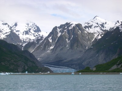
June 25, 2008: We are now working our way up the west arm of Glacier Bay. This is definitely the more scenic and rugged part of the park. The mountain peaks are more jagged, the valleys carved wider and sheer rock faces have little or no forest growth. Once again as we get closer to glaciers the water changes color to its opaque aqua shade from the emerald green. We are planning to stay at Reid Glacier and spend tomorrow exploring the Grand Pacific, Margerie and John Hopkins Glaciers.
We anchored in Reid Inlet and took the dinghy to the glacier. It has receded back enough and the tide was out so there was plenty of beach area to land and walk around. Right near shore the water color was milk white and you could not see the bottom until there was only about 6-8 inches of water. Recent evidence of calving could be seen; unless we have a very high tide the ice bergs will remain on shore. The vivid blue color was intense close up. We took the opportunity for photos to show how big the glacier is compared to us. One "small" ice berg on the beach was to our waists once we got up close.
Here the glacier facts about Reid:
• Height - 130 ft above waterline
• ¾ mile wide
• 9.5 miles long
• flows 1-3 ft/day; 800 ft/year
• status - slowly receding/thinning
The following is a paragraph from the visitor's guide that I found very interesting -
"Glacial melting and a warm ocean (water expands when warmed) will contribute to sea level rise. Fortunately, though, Glacier Bay's shorelines are unlikely to be inundated. As the park's glaciers melt and move their great weight from the land, the Earth's crust will slowly "bounce upward" to compensate. This "isostatic rebound" should more than keep up with rising sea level."
I had never heard of this concept. But on the other hand, the article also said the glaciers have thinned significantly due to increased global temperatures, and more importantly, the rate of thinning is increasing. In my biosphere it has been damn cold for 9 months now and I am ready for 70-80 degree weather ... however, no warmer!
The park service is in a dither over invasive plants, i.e. the dandelion, the reed canary grass and oxeye daisies. In 2004, researchers conducted inventories of invasive plant infestations on 1,000 acres and removed 3,000 pounds of the bad boy plants.
And if you want to commit the almost perfect murder, the Baneberry plant, is deadly to humans. Ingesting one berry can cause numbness in the mouth and tongue. (Bob is threatening about trying one on me just to keep me quiet for awhile ... ) ... 3 berries can kill a child and 6 berries will shut down the respiratory system in adults. The shiny hard berries appear in July and August and in color are candy apple red or white. Scary!
Reid Inlet, Reid Glacier Air Temp: 58 degrees
Lat: 58.51.768 N Water Temp: 48 degrees
Long: 136.49.051 W Wildlife: eagle, dolphin (only one each)
Nautical Miles: 28 Hours: 5
June 26, 2008: If felt strange all night knowing we were parked up close and personal to Reid Glacier ... well not that close but close enough. The cruise ships were already making their appearances this morning. I am sure the "Ponderosa" and her motley looking crew will grace many photo albums. Today we visited Lamplugh, John Hopkins, Margerie and Grand Pacific glaciers. The Rendu glacier and inlet were off limits to motorized vessels but we got a long distance view. We could see the non-tidal Carroll Glacier up the Queen Inlet; it looked like a huge gravel pit.
The John Hopkins Inlet was closed from the glacier terminus to about 8 miles out due to seal pup season. It didn't matter anyway, the inlet was choked with ice bergs and we could not have gotten any closer. The glaciers we saw today were all magnificent in their own ways. But to me, it is what they left behind that is more impressive ... giant mountains, steep granite faces, long sweeping valleys.
Once again, the weather was not cooperating and mountain tops blended in with the clouds. We did finally get to see mountain goats - 2 nannies and 2 kids. At first I thought they were a snow patch but it kept moving around. Since we have been here all the animals seem to be disguised as rocks, tree trunks, ice bergs or snow patches. The sea lions, seals and bears blend into the shoreline. At least we can see the kayakers ... all dressed in bright yellows and reds.
Here are facts about the glaciers we saw today:
• Lamplugh
o Height - 180 ft above waterline, 40 ft below
o ¾ mile wide
o 16 miles long
o flows 2-3 ft/day; 1,200 ft/year
o status - stable to receding/thinning
• John Hopkins
o Height - 250 ft above waterline, 200 ft below (a grand daddy)
o 1 mile wide
o 12.5 long
o flows 10-15 ft/day; 4,000/yr
o status - advancing/thickening
• Margerie
o Height - 250 ft above waterline, 100 ft below
o 1 mile wide
o 21 miles long
o flows 6-8 ft/day; 2,000/year
o status - stable
• Grand Pacific
o Height - 180 ft above waterline, 60 ft below
o 2 miles wide
o 34.5 miles long
o flows 1-4 ft/day; 350-1200 ft/yr
o status - slowly receding/thinning
The Grand Pacific from a distance was incredible - a long ribbon of ice. However, the end of the glacier was covered with rocks and whole area was totally black. Not exactly one's idea of lily white sparkling glaciers.
Aside from the goats, we saw a few eagles, one whale and sea birds - not much for wildlife today either. But this anchorage may be promising for some more bear sightings. At each glacier the cold mountain air flowed down upon us; it was bitter cold. Sure glad I can be snuggly warm in the boat vs making camp in the rain and sleeping in a tent. I must be showing my age!
Blue Mouse Cove Water Temp: 56 degrees
Lat: 58.46.678 N Air Temp: 56 degrees
Long: 136.28.896 W Wildlife: as noted above
Nautical Miles: 40 Hours: 8
June 27, 2008: There is liquid sunshine today and the clouds are hanging into the water so we decided to head back to Barlett Cove. We have to leave tomorrow afternoon anyway so we can use the morning for a short hike and take in a couple of park documentary films.
At least the wildlife was more abundant ... we watched whales and sea otters feeding. What significant size differences in sea creatures and yet both are equally fun to admire. A few eagles made appearances, but they were numbered by the kayakers.
The visitor's guide does a very nice job of providing information whether you are guest of the lodge, kayaker or boater. They even have listening station kiosks so you can hear the whales and other critters of the sea. The whole week has been extremely enjoyable; but we are also very fortunate that our whole trip up here has been just as beautiful. Not many of us can say that.
Barlett Cove Wildlife: whales, sea otters, eagles
Nautical Miles: 30
June 28, 2008: The rains finally let up enough this morning so we could go into the lodge. The anchorage area rocked and rolled last night thanks to the SE winds. Doesn't matter whether it's a business location or anchor site ... its location, location, location!
We walked along the "Forest Loop Trail", an easy 1 mile trip on part boardwalk and part dirt/gravel surface. It's nice to see accommodations for those wheelchair bound. From there, I had to leave behind some cash in the gift and book shops at the lodge. I would highly recommend coming to this park even if you don't have a boat. There are small plane flights from Juneau to Gustavus, van service to the park and nice accommodations and restaurant at the park lodge. You can take a day long boat trip to the glaciers, rent kayaks and take in other hikes around the area.
And for the younger members of your family (between the ages of 6 and 12), you too can become a park ranger by completing an official "Junior Ranger Activity Book" and be awarded a special badge!
We checked out of the park as required and made our way to Inian Cove about 20 miles west. Beyond the wicked rain storm that hit us was Cape Spencer and the north Pacific Ocean; just another cold, rainy, blustery day in paradise.
Inian Cove, Inian Islands Air Temp: 52 degrees
Lat: 58.15.178 N Water Temp: 57 degrees
Long: 136.19.770 W Wildlife: sea otters, whales, eagles,
Nautical Miles: 20 Hours: 3
June 29, 2008: The skies were relatively clear and the sun shining this morning when we left Inian Cove. We took the passage way between islands and were treated to a sight of about 100 sea lions basking on their favorite rock and barking away at each other. Boy, did they stink! We could smell them before seeing them. After clearing all the rocks and islets we had an open and beautiful view of the Pacific to the west, the Brady Glacier to the north and the Chichagof Island to the south.
We could see whales blowing, dolphins, sea lions and finally saw a puffin floating on the water. What a colorful bird! Thankfully we had nominal ocean swells and found ourselves enjoying the vast view of water, ice and mountains.
We are heading for the small community of Pelican in the Lisiankski Inlet. Their main street is an elevated board walk for the 115 residents. Little did we know that a 5 day fishing season was about to open and the marina would be packed with eager fishermen. The first slip we tried was too small so we had no choice but take an outside slip without having the benefit of breakwater. The wind, of course, was puffing up to 15 kt so we were potentially in for a rough night.
After getting settled, we wandered the boardwalk absorbing the sights and sounds of the area. Since it was Sunday, the place was extremely quiet. Rose's Bar, which apparently is a landmark around here, was open and serving dinner at 5:00 pm. Rose was there tending bar at the spry young age of 75. She asked if I was the hired help she ordered from Vegas. Of course I was, I replied. I guess my costume was in the lady's room whenever I was ready. Rose had 7 kids (4 girls and 3 boys), sold the bar 3 times and had to repossess it 3 times. She has owned it for 30 + years.
We ate dinner just to say we ate dinner there and promptly got a gut ache a few hours later. The locals were smoking like chimneys so we didn't linger. At least the TV was on and we got some news updates. We haven't watched TV or listened to news in two months. I guess we will be missing the summer Olympics ... which is too bad, I always enjoy watching them.
Pelican Air Temp: 60 degrees
Lat: 57.57.525 N Water Temp: 50 degrees
Long: 136.13.741 W Wildlife: puffin, whales, sea lions, dolphins
Nautical Miles: 30 Hours: 4
June 30, 2008: The winds had finally settled down last night and we enjoyed a quiet marina. We planned to stay the day and catch up on chores. The laundry facility was not in great shape ... 2 out of the 4 washers and 2 of the 4 dryers worked. So this adventure took twice as long as normal since I had 4 loads. Oh well, I had no where else to go. I sat on outside bench along the boardwalk and watched all the activity. Got the scoop on who owned what, how the supplies got here, the ferry schedule, where to fish and the latest on the fish cold storage business ... and ate lunch at the only other restaurant in town and yes, promptly got another gut ache.
The real entertainment in town is the sea lion and eagles feeding in the marina area and the lovable golden retriever that guards the boardwalk.
As you tell, we have had a busy day ... it's raining now ... so I am thinking a nap may be in order.
July 1, 2008: We fished our way out of Lisianski Inlet, catching some small ones no keepers. The 40% chance of rain was now 100% with fog. This is unfair ... its July 1st! We wanted to go to Elfin Cove for the 4th. Unfortunately the transient dock was already full so we turned around and continued on to Inian Cove. The sea lions were out in full force barking at our return.
To our surprise, a bright green sailboat showed up in the horizon heading our way ... it was Steve and Elsie on Osprey. I was excited to see familiar faces and have someone else to talk to. They rafted with us, we all enjoyed dinner and wine, and watched the skies clear to view the St Elias Mountain Range. What a nice evening!
Inian Cove, Inian Islands Air Temp: 60 degrees
Lat: 58.15.178 N Water Temp: 47 degrees
Long: 136.19.770 W Wildlife: sea otter, whales, eagles, sea lions
Nautical Miles: 20 Hours: 7
July 2, 2008: The good weather must be following the Hulsizers since today was one for the record books. We drank our morning coffee in the cockpit - it was warm and sunny ... and planned our busy day for sightseeing.
We knew there were sea lions hanging out on their favorite rock between islands so we unhooked Osprey from the raft and proceeded on our tour. What a sight to see ... at least a 100 sea lions swimming or sunbathing on a rock along with sea gulls and cormorants. The young ones were so curious ... they would swim close, dive or jump in the air ... then disappear only to come up closer. The fat boys just hung out on the rocks ... and there were some whoppers!!
We cruised around the western most island of the Inian Island group and checked out the other sea lion groups plus had a spectacular view of the Brady Glacier and the mountains behind it (St Elias Range). We topped the evening off with a potluck dinner, wine and a few stories.
Inian Cove, Inian Islands Wildlife: sea otters, whales & sea lions
July 3, 2008: Elfin Cove was already jam packed with other boaters, our hopes were dimmed to participate in the July 4th activities. So off we went to Hoonah to visit and enjoy the celebration in their community. We sailed part of the way and then motored ... and we were treated to more whale sightings off Pt Adolphus. We plan to spend a couple of days here ... a lot of the boats from other anchorages that we have gotten to know are also moored. There is a new zip line from a mountain top to the beach we may have to try. I am up for it ... but we might save the experience once Tyler, our grandson, joins us on July 20th.
Hoonah Air Temp: 62 degrees
Lat: 58.06.408 N Water Temp: 56 degrees
Long: 135.26.741 W Wildlife: whales, sea lions, sea otter, eagles
Nautical Miles: 35 Hours: 7
Comments
| Vessel Name: | PONDEROSA |
| Vessel Make/Model: | Valiant |
| Hailing Port: | Issaquah, WA |
| Crew: | Bob Custer & Sherry Heen |
| Home Page: | www.sailblogs.com/member/ponderosavoyages |
Gallery not available
Ponderosa Voyages

Who: Bob Custer & Sherry Heen
Port: Issaquah, WA