
Providential Sailors
Cruising on our sailboat to enjoy a life worth living: together. It's time for a little 'pay-back' in the most positive sense.
26 November 2010 | Back in the work force...
24 November 2010
25 October 2010 | High & Behind
20 October 2010 | Southern chesapeake Bay
20 October 2010 | New Point Comfort Lighthouse
20 October 2010
19 October 2010 | Approaching New Point Comfort/ Ches Bay
19 October 2010 | Chesapeake Bay, South of the Rappahannock
16 October 2010 | the BEAUTIFUL Carter's Cove Marina
14 October 2010 | Carter's Creek, Virginia
13 October 2010 | CC Marina
12 October 2010 | The BEAUTIFUL Carter's Cove Marina
10 October 2010 | Carter's Cove Marina
03 October 2010 | En Route from Horn Harbour to Marina
02 October 2010 | Horn Harbour
02 October 2010
02 October 2010
29 September 2010 | Windmill Pt. to Tangier
29 September 2010 | Tangier Island
28 September 2010 | Near Weems, Virginia
Thanks for Riding Along!
26 November 2010 | Back in the work force...
Ray

Dear Friends,
It's been a great adventure! Certainly it's been different from how we thought that it would go, but our lives SHOULD keep us interested - ne? This blog was begun to keep friends & family up to date while we were out of the country. Now that and we're not leaving the country as we thought and we're all in touch by the 'normal' means, we'll just say 'thanks for riding along' and for all of your support!
Fair Winds & Friendly Natives,
R&K
Ps. Feel free to sing the Toilet Song as LOUDLY and often as you like! Our little gift to you.
Nav Systems: GPS, Back-Ups & etc.
24 November 2010
Ray

There seems to be some confusion about GPS & me. A Fellow asked about this in an earlier post...
First though, the Three Rules of Life as pontificated in a bar by four VERY iner-brea-ted, I mean in-eebree-ated, in -y -bree - oh forget it, I mean that we were drunk ex-soldiers. (My Army buddies and myself)
1. Life in not fair.
2. Always leave yourself a way out. (I prefer at least three ways out...)
3. Trust no one. (Leads to a safe, but dull life...)
We absolutely have GPS aboard. There is an ancient, coal-fired Icom GPS/chart plotter (yes, they made them for a short period of time) and there is the back-up, hand-held GPS in the emergency navigation kit. I use them, like them and appreciate them, specifically because as he very accurately pointed-out, it lowers the 'overhead' of what is requried to safely navigate. Probably the MAIN reason that I appreciate GPS, is because I have very accurately navigated using map, compass and map/charts since I was a boy and so GREATLY appreciate what GPS does so easily.
GPS is of course not a panacea. A GPS in the hands of someone who already knows how to navigate is powerful and very, VERY handy in zero-zero weather, large current and lee-way situations & etc. It is however, only one tool and has lead many to THINK that they were "navigating", when they were really only "sailing the cursor". On the other hand, the GPS system as a whole is entirely dependent upon many layers of interlocking U.S. Political, military and civil infrastructure. In the same way that cell phones are not able to communicate without the operating infrastructure of power, towers and centralized control apparatus, neither can GPS assist in navigation without it's infrastructure in place.
Never Bet You Life and the lives of those aboard on any ONE 'Thing'. Have Back-Ups.
Much of my life, I've been attached to military operations and defense engineering. The life of experience related to these two tell me; anything can break and man can 'break' anything. I am known for having back-ups for my back-us. I mean, I even pound Morse code messages over short-wave radio for delivery to friends through the only remaining commercial maritime shore station in north America; KSM in Bolinas, California. It's a Saturday afternoon only type of event, with a 'living museum' station, fun and it works. We also have the PACTOR for reliable radio e-mail. Best to have layers within layers: system redundancy. It's the same with GPS and now with bilge pumps! (another lesson learned)
The GPS system is one system. Carry spare receivers - they're inexpensive, but they still require the one system to be operational, not jammed locally/regionally, not turned-off in some part of the world for political reasons, not incinerated by solar flares, CME, EMP, HERF or EIEIO (part of the O.MacDonald Project...)
When I lay-in a course for coastal navigation, I usually do it on laptop, then print my charts and put then into a clear plastic cover. This is set-up to use both GPS/chartplotter and compass/eyeball navigation: incase of failure. I list bearings in magnetic, rather than true North , so that if there is a failure of my brain - quite likely , actually...- I can steer what I see on the compass, rather than interpreting the offset. Fatigue leads to poor math skills, especially in rough conditions.
An example: the GPS/Chartplotter has a line on it and it's easy to follow between way points - great! I can also look out with binocs and know that I will make my turn when I am (for example) roughly 200 yards directly north of RED4. That way, it the GPS decides to stop at that point, I am simultaniously steering a magnetic heading, counting time and distance (DR) and keeping track of my position with casual compass bearings taken from prominent objects.
This came in handy when I had one GPS, reputed to be waterPROOF, die on me in what was likely a down burst. It also came in handy recently when it was a bit rough and I fat fingered the GPS by striking an incorrect key, putting it into some odd mode requiring a complete reset, just as I was supposed to be making a course change between shoals. No worries though, because I had my compass bearing, distance and significant object notes in indelible ink right in front of me and the current mini-chart in the plastic. I reset the GPS once we were clear of the shore and worked through the problem until it was where I wanted it to be. 'Wanted' not needed.
Another factor is that I love navigation; always have. I used to teach outdoor survival skills and one of my favorite topics was 'Field Expedient Navigation' i/e, you're on the run with not much more than a pair of flip flops. How can you know your position and direction of travel? Now as a sailor, I dress like this regularly, but for different reasons ;^) So, I enjoy my very basic level of celestial navigation and use coastal navigation with chart and compass. These are back-up systems which , after all, were the PRIMARY systems not very long ago and for hundreds of years before that.
So, there's an overly long answer to a simple question. Yes, I have GPS aboard, but I rarely if ever navigate with only GPS. I am generally keeping note of my position on a paper chart, using compass bearings on known objects when in view, maintaining a charted DR position based upon my estimated speed and heading. It takes a minute or so to update and is worth it, it's a bit of nautical history I that can live every day.
Fair Winds & Friendly Natives,
Ray
A Different View
25 October 2010 | High & Behind
Ray

I wanted to share the view of Providence which we rarely see. this is looking down from the barbeque deck on our little girl during an unusually low tide.
>R&K
>R&K
Romping & Splashing!
20 October 2010 | Southern chesapeake Bay
Ray
Providence, playing like a puppy in the Chesapeake chop...
A funny thing Happened On the Way to The Bahamas (Pt#3)
20 October 2010 | New Point Comfort Lighthouse
Ray
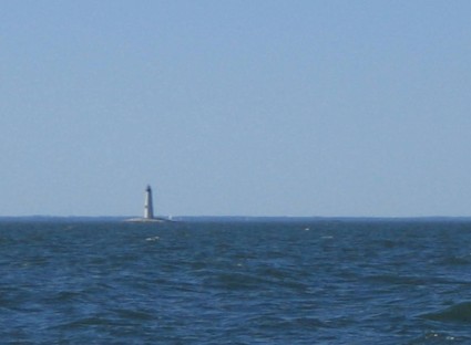
This is New Point Comfort light as seen from a few miles away. The entire area is SHALLOW water, so while it looks like you're in plenty of water, we're routinely seeing 17, 12, 10 and etc. feet on the depth meter and this is in the course I set through the deep parts. Much of the Chesapeake Bay is like this, which is why it can go from tranquil to tempest in a very short time, with little warning.
The light was installed here to warn deep draft commercial vessels away from this shore. In the days before GPS, lights on towers ands buoys were used to accurately determine position. These dyas it may seem old fashioned, but should a boat's electronic navigation fail, then it's back to the basics of compass bearings on known objects. When I set course on the GPS, I make certaint hat visual markers are also available, incase we loose 'the magic box of electrons'.
There is a difference in perspective when a landsman or a sailor looks at a light house. To a landsman, they often think it's a sign of safety and a snug harbor. To a sailor the light house may be a sign of a snug harbor approaching, but the light itself was put there to warn of DANGER, so keep offshore a safe distance! If you sail straight toward a lighthouse, you are sailing into dangerous waters. Use the light and tower as a position refference, not as a destination, anymore than you would drive a jeep in a war zone toward a sign that said "DANGER MINES!"
(We encountered no mines during this portion of the sail and will attempt to maintain this perfect record... ;^)
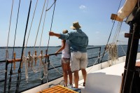
Looking Across The foredeck
20 October 2010

This picture is from an earlier trip, but will give you the view that we have...
| Vessel Name: | Providence |
| Vessel Make/Model: | Bayfield 32c |
| Hailing Port: | Weems, Virginia |
| Crew: | Ray & Karen |
| About: | |
| Extra: | "Say you can, or say you can't. Either way you're right." ---- Henry Ford |
Gallery not available
About Us
Who: Ray & Karen
Port: Weems, Virginia