s/v Proximity
The Voyages and Adventures of "Your Rock and Roll Argonauts".

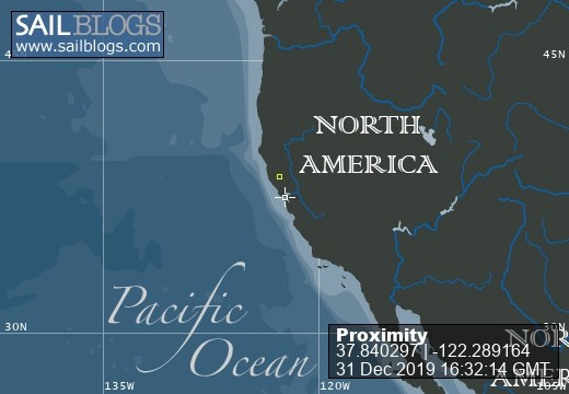
31 December 2019 | Emeryville Roadtrip
16 July 2017 | Wrangell Harbor
15 July 2017 | Petersburg, Alaska
12 July 2017 | Baronof Warmm Springs
10 July 2017 | Tenakee Inlet
08 July 2017 | Hoohah
07 July 2017 | Elfin Cove Dock
29 June 2017 | Yakutat City Dock
29 June 2017 | Yakutat City Dock
29 June 2017 | Yakutat City Dock
26 June 2017 | Gulf of Alaska, East of Kayak Island, West of Icy Bay
25 June 2017 | Gulf of Alaska
24 June 2017 | Seward, Alaska
21 June 2017 | Seward, Alaska
21 June 2017 | Seward, Alaska
20 June 2017 | Seward, Alaska
22 April 2017 | Seward, Alaska
22 April 2017 | Passage to Kodiak
22 April 2017 | Chignik,, Alaska
22 April 2017 | Sand Point, Alaska
Likuliku Bay
17 June 2012 | At anchor - Likuliku Bay, Malolo Island, Fiji
Rod
After a month, yes, that's right, A MONTH!!! at Musket Cove, it was time to move on and see more of Fiji. But before you consider us to be pathetic for indulging ourselves for a month at 5 star resort, just consider this. We're on vacation! We can do what we want. There is no "wrong way" to cruise.
When you look at the chart (click on the map at the right side of this page), it may not look as though we got far, but consider: Fiji eats boats. Every year. Just this year alone, since we have been here, we know of three boats on the reef, one who sunk. This is because Fiji has an enormous amount of reefs and marginal charting. A reef may be shown on the chart, but may not be located where the chart says it is. Or maybe the chart doesn't show it at all. Or maybe a reef is shown, but there is no reef. Given that so many modern sailors navigate with GPS with an accuracy of better that 20 meters, what is the problem? The problem is that the original charts were drawn back in the Captain Cook days (late 1700s). Some have been updated, many have not. The GPS is indeed accurate, and shows you exactly where you are, but the chart is not necessarily correct. So the way to navigate Fiji is to use your eyes and proper lighting. The reefs are remarkably visible when the light is good. This will be a sunny day from the hours of say 10:00 to about 2 or 3 in the afternoon. Before or after, you cannot see so well. A cloudy day, you really cannot see so well. Night? Forget it.
So, this morning after breakfast of local onion bread, fresh pineapple with coffee (doesn't that sound so tropical?), we went to the office, checked out, like at a hotel, showered one last time on shore, said goodbye to friends, got the dinghy engine on to its mount on the transom, dinghy on deck, instrument covers off, etc, etc, we cast off at 11:30. This was so late partly because the sun didn't come out until late - it was overcast and cloudy, and partly because we needed to enjoy a late morning snack. Our friend Sue on s/v Cable's Length from Perth, Australia had just baked muffins and had friends Bill and Sue from s/v Lady Nada, also from Perth, deliver them. Mmmmmm good. They were still hot.
We really thought we were in luck as we left the anchorage. Another boat we had met the other day, S/v Irma from Czech Republic, had just left and was in front of us. Wonderful, we now had a canary in the coal mine to feel the way through the reefs. But, alas, they were perhaps unsure of the way, pulled over to let us by and followed us through the rat maze of reefs to Likuliku. We were quite happy to help out, of course, and they were so nice as to call us on the radio afterwards thanking us. Very nice people.
We then arrived at Likuliku Bay, a mere three miles away at 12:45. Our intended destination is still about 18 miles away, but this was a good anchorage to get us out of the slow going heavy reef section, and set us up for an early departure tomorrow morning. And it is phenomenal. It is only the other end of Malolo Island, but it has a completely feel and view - all of it beautiful. The plan is to leave in the morning for Navadra. Lady Nada and Cable's Length are going to meet us there, but they wanted another day at Musket. Ha! It's a vortex! Possible fly in the ointment is that rain is forecast for Wed and Thur. When will it cloud up? There is no real wind associated with it, or so says the forecast, so if the morning is clear, we will make Navadra tomorrow. If not, too bad, but this place is beautiful.
Comments
| Vessel Name: | Proximity |
| Vessel Make/Model: | Swan 41 |
| Hailing Port: | San Francisco |
| Crew: | Rod Lambert, Elisabeth Lehmberg |
| About: | |
| Extra: | 2017 Update. From 2009 to Summer 2016, we sailed the South Pacific Ocean, visiting many many wonderful places and meeting incredible all along the way. Finally, it was time to do something a little different, so we headed North. North to Alaska. The dream continues. Welcome! |
| Social: |
|
Proximity's Photos - Main
No items in this gallery.
About Us
Who: Rod Lambert, Elisabeth Lehmberg
Port: San Francisco