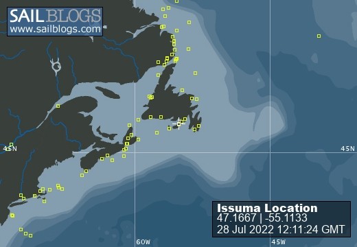
Issuma

28 July 2022
28 July 2022
08 May 2022
18 April 2022
07 April 2022
04 March 2022
17 February 2022 | Little Bay, Marystown, Newfoundland, Canada
16 February 2022
09 February 2022
06 February 2022 | Little Bay, Marystown, Newfoundland, Canada
05 February 2022 | Little Bay, Marystown, Newfoundland, Canada
01 February 2022 | Little Bay, Marystown, Newfoundland, Canada
30 January 2022 | Little Bay, Marystown, Newfoundland, Canada
25 January 2022 | Little Bay, Marystown, Newfoundland, Canada
24 January 2022 | Duricle Cove
17 January 2022
11 September 2021 | Little Bay, Marystown, Newfoundland, Canada
27 August 2021 | Grey River
26 August 2021 | Grand Bruit
26 July 2021 | Isle Valen
Re: Current Position of Gulf Stream Question
05 May 2010
Richard
George and Hank, many thanks for the information on the Gulf Stream position.
For anyone else who is interested, here is the info:
(1) http://www.bermudarace.com/LogisticsResources/GulfStreamTutorials/tabid/204/Default.aspx walter.bohlen@uconn.edu Frank Bohlen is a Professor of Oceanography in the Department of Marine Sciences at the University of Connecticut. For the past forty years he has been studying ocean and nearshore currents and transport. He won the Mixter Trophy as navigator of the winning yacht in the 1986 Newport Bermuda Race.
(2) http://users.erols.com/gulfstrm/ gulfstream@comcast.net Professional Satellite Oceanographer Jenifer Clark and professional Meteorologist Dane Clark, both with over 30 years supporting the marine community, invite mariners to take advantage of their real-time ocean charts and weather forecasts for sailboat racing, boat deliveries, ocean cruising, and offshore fishing. Using infrared imagery, satellite altimetry data, and surface isotherm data, oceanographic analyses are produced and available for the Gulf Stream area and all the major currents of the world. Waypoints are also provided for taking advantage of favorable currents and for avoiding unfavorable ones.
(3) David Burch and Luis Solterto and Lee Chesneau would be people to ask and they are all associated with Starpath. There are also several other's that are part of Marine Wx education at StarPath www.starpath.com helpdesk@starpath.com
(4) Herb Hilgenberg http://www3.sympatico.ca/hehilgen/vax498.htm hehilgen@sympatico.ca Would be worth listening to see if he might be talking to vessels transiting a similar route to yours.
South Bound II, Herb, provides a daily ship-routing/weather forecasting service, as a hobby, on marine HF/SSB frequency 12359.0, starting at 2000 UTC until 2200 UTC or until completion of traffic. 8294.0 and 16531.0 are used as alternate frequencies as announced from time to time, subject to propagation Vessels are welcome to check in between 1940 and 2000 UTC, and should then stand by, until contacted again once their area gets covered. New check-ins should provide a short description of their location on checking in for the first time. At 2000 UTC, Herb will acknowledge all readable check-ins. Once on the South Bound II log, stations are encouraged to check in and stay in contact daily, until completion of passage. As part of the service each vessel is requested to provide current latitude and longitude to the nearest minute, when called back; also to provide true wind speed and wind direction, the barometric pressure, sea state and other pertinent data, such as sky conditions/squalls. Each vessel will receive daily, an extended four to five day route forecast, including way points, if necessary, to assist in avoiding potentially unfavorable conditions. Individual vessel forecasts are prepared in advance of air time, utilizing and editing numerical forecast models and other available data and products. Forecasts are provided as value added information, not as a copy or duplication of otherwise available or published offshore/high seas forecasts.
Fair winds, George Ray
Navy stuff is not as available as once was BUT the NOAA Ocean Prediction Center does provide a USN GS graphic at: https://oceanography.navy.mil/legacy/web/cgi-bin/graphic.pl/metoc/223/19/0-0-5/1
The graphic includes north and south wall locations as well as warm/cold eddy locations and sst.
In general,in my opinion the best ocean info on weather, currents, SSTs, high seas, etc are on the OPC site: see: http://www.opc.ncep.noaa.gov/newNCOM/NCOM_SST.shtml
Let me know if I can be of further assistance. Hank
Comments
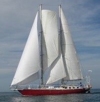
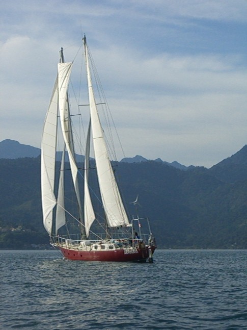
| Vessel Name: | Issuma |
| Vessel Make/Model: | Damien II, 15m/50' steel staysail schooner with lifting keel |
| Extra: | Designed for Antarctica. Built in France by META in 1981. Draft 1.3m/4.5' with keel up, 3.2m/10.5' with keel down. More details at http://www.issuma.com/rhudson/issumaboat/IssumaDetails.htm |
| Home Page: | http://www.issuma.com/rhudson/ |
| Social: |
|
Issuma's Photos - Main
 |