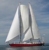
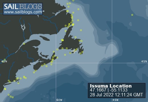
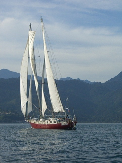
Fri Aug 19 10:01:00 EDT 2011, Magnetic North Pole
As a followup to the post about Magnetic Compass Useless, here is the location of the Magnetic North Pole, so you should be able to click on the blog map to see where it is.
Latitude:N 82° 17' 60" Longitude:W 113° 24' 0"
Magnetic North Pole position supplied by Douglas Pohl of northwestpassage2011.blogspot.com.
|
|
Thu Aug 18 10:02:00 EDT 2011, Franklin Strait
Being close to the magnetic north pole means that magnetic compasses don't work. The needles try to point down. I'm not sure where the magnetic north pole is now (the magnetic poles move), but it is within several hundred miles of us. Issuma's compass stopped working in NW Baffin Bay.
Nautical charts have compass roses on them, where a compass dial in relation to True North and inside it, a smaller compass dial in relation to Magnetic North. The picture is from a Canadian arctic chart.
|
|
Wed Aug 17 10:02:00 EDT 2011, Baffin Bay
The well-rounded iceberg in the picture looks like it has been floating around for a while, and has turned at least partially over before, based on how rounded it is. Possibly this is a bergy bit, not an iceberg, the difference being a bergy bit (piece of ice broken off an iceberg) shows less than 5m/15' above the surface of the water.
Amos, that is a great poem (in the comments to an earlier post). Thanks for sharing it.
|
|
http://www.youtube.com/watch?v=TVY8LoM47xI
Tue Aug 16 10:02:00 EDT 2011, Lancaster Sound
The stark and striking coastline of Devon Island.
The blog is a bit behind, we are now in Bellot Strait.
To answer George's questions: We left Upernavik with 1400 litres of fuel, which gives a theoretical range under power (at 4.5 to 5 knots) of 1400 miles. A lot less if in ice. Things are much different now than in Amundsen's time. Besides having GPS, radar and better charts, there is much less ice now. Getting trapped in the ice is still a great danger, as there is still ice, and even in areas where the new ice has melted, winds can take older ice breaking up in other areas and bring it into areas that would otherwise be clear, but on the whole, the arctic ice is melting. As for seal and bear hunting, we have enough ammo for protection against polar bears, but not really enough for subsistence hunting.
|
|
Mon Aug 15 10:02:00 EDT 2011, Baffin Bay
While much of the crossing of Baffin Bay involved motoring in calm, foggy conditions, sometimes there was beautiful sailing across enticing, misty, sunlit seas.
|
|
Sun Aug 14 10:02:00 EDT 2011, Baffin Bay
In the middle of Baffin Bay, after a few days of seeing nothing but sky, water, ice and fog, Jordan saw a sailboat in the distance. I called on the VHF radio for sailboat at our approximate position, and Jeffrey Allison of Essamy answered. We had met in Upernavik, as we were both on the same dock. They left a little later than us and followed a different course--going north of the ice in the middle of Baffin Bay (on yesterdays image) instead of south of it like we did. We had a chat and took some pictures, then continued on our separate ways.
Thanks all for the comments on the blog. The airtime on the satellite phone has been extended, thanks Timothy. Victor and Peter, thanks for the ice reports. Blair, thanks for the Arctic Bay info.
Yvonne, thanks for thinking of us. The sailboat you saw was probably either Matt Rutherford singlehanding a 27 foot sloop, or an Austrian family's boat. If you're going to be staying in the Lancaster Sound and Barrow Strait area, we'll probably miss you, as we have a fair wind and are heading towards Prince Regent Inlet (I'm behind on the blog).
|
|
To find the hand of Franklin reaching for the Beaufort Sea;
Tracing one warm line through a land so wild and savage
And make a Northwest Passage to the sea.
Sat Aug 13 10:02:00 EDT 2011, Baffin Bay
William Baffin was the pilot for Robert Bylot's 1616 voyage from England, around Kap Farvel (south tip of Greenland), into Davis Strait, up the west coast of Greenland to Melville Bay, then to Smith Sound and Lancaster Sound, then south along the coast of Baffin Island. This was a great achievement for the time (no European had gotten so far beyond Davis Strait), and many doubted that the accounts of the voyage were true. For two centuries afterwards, instead of showing Baffin Bay, charts showed a dotted bulge north of Davis Strait noting the legend of Baffin Bay.
The picture is from an Ice Chart, used because it was handy, and already in digital form. I'll come back to Ice Charts another time. The Ice Chart was received as a weatherfax transmission, hence the grainness and noise in the image. Issuma's track is roughly shown on the map--we intentionally went south of the ice in the middle of Baffin Bay, and then did some tacking later, as required by the wind at the time. Much time was spent motoring in no wind and dense fog.
The arrows on the map roughly show the currents in Baffin Bay (I drew them in, they are not part of the ice chart).
If the blog posts stop after this entry, it is due to a problem getting my Iridium satellite phone airtime refilled, complicated by a technical problem with the satellite phone vendor's telephone system.
|
|
congratulations, have a great time
Remember - it took Amundsen 3 years to complete the northwest passage!
Thu Aug 11 11:02:00 EDT 2011, Upernavik, Greenland
The tidy little community of Upernavik (it means The Spring Place). With a population of about 1100, Upernavik is the largest settlement in the area. The harbor is very open to the NW, but there are other places to anchor around the island of Upernavik to get shelter.
We made a very quick food and fuel stop here, we arrived after midnight, tied up to a fishery research boat on the dock, and were gone early in the afternoon. The blog is now a few days behind.
Thanks for the comments on the blog. Yes, Iceland is just around the corner from Greenland and it would certainly be a nice place to visit again.
|
|
Tue Aug 9 11:02:00 EDT 2011, near Upernavik, Greenland
In 1587, John Davis made his third and last voyage to Davis Strait and what is now called Baffin Bay. Davis named this 300m/1000' cliff Sanderson's Hope, after his main financial backer, William Sanderson of London. Davis wrote 'no ice towards the north but a great sea, free, large, very salt and blue, and of an unsearchable depth'.
A northerly gale prevented Davis from getting any further north than Sandersons Hope, and he sailed back to England.
Thanks for the comments to recent posts.
I'm not able to reply directly to comments while at sea, but I do receive them. It was interesting to read how hot it is in more temperate climates. It is certainly not hot here :). As to the question of where are we going next....stay tuned :)
|
|
Tue Aug 9 11:02:00 EDT 2011, Greenland
When I was in Brazil, I took a liking to the drink they have there called caipirinha. It is made with lime, sugar, ice and either cachaca (a spirit from sugar cane) or vodka.
One of the things I wanted to do on this trip to the arctic (well, not the main objective :) ) was to have a caipirinha with ice from an iceberg. I brought some cachaca and some caiprinha mix (we don't have limes aboard) from Brazil for this purpose. In the picture, Lin is holding a piece of ice from an iceberg, and I have the cachaca and caipirinha mix.
On a more serious note, summer in Greenland is dominated by the Greenland High (high pressure, clear skies, light winds), so it can be deceptively tranquil in the arctic. While there are few signs of it now, summer is ending, and the easy, pleasant conditions seen in the pictures along with it.
|
|
Michael
