
Roaring Girl
The adventures of the yacht Roaring Girl wandering the seas.
12 August 2013 | Ipswich, England
20 July 2012
20 July 2012
18 July 2012
17 July 2012
16 July 2012
10 July 2012
05 July 2012
04 July 2012
03 July 2012
03 July 2012
03 July 2012
02 July 2012 | Shanghai (high up!)
02 July 2012 | Shanghai (high up!)
02 July 2012 | Shanghai (high up!)
02 July 2012
02 July 2012 | Shanghai
01 July 2012
01 July 2012 | Moganshan Lu, Shanghai
Past the reef
28 June 2010

To get into the Realle mooring field, you must then round the Neri Reef, the western (inland) end of which is marked by this big beacon. It may be possible to go between he reef and Pte di Trabuccatto, but if so it will be in 5m or less. We saw one yacht arrive by this route. We went round the outside.
The beacon should be bearing not less than 305 degrees, and on that heading you will see at least 13m of water along the fringe of the rocks.
The beacon should be bearing not less than 305 degrees, and on that heading you will see at least 13m of water along the fringe of the rocks.
Comments
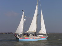
| Vessel Name: | Roaring Girl |
| Vessel Make/Model: | Maxi 120 |
| Hailing Port: | Ipswich |
| Crew: | Pip Harris and Sarah Tanburn |
| About: | Captain Sarah and Chief Engineer/Mate Pip moved on board in 2003 and finally made the break in 2006. Roaring Girl, launched in 1977, has already been round the world once, and has a lot more seamiles than the two of us put together. |
| Extra: | These pages aim to bring you our adventures as they happen, as well as Roaring Girl's sailing prowess. And to show off Pip's silverwork as well. |
Gallery not available
Who we are
Who: Pip Harris and Sarah Tanburn
Port: Ipswich
SailBlogs Friends

