
Roaring Girl
The adventures of the yacht Roaring Girl wandering the seas.
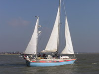
12 August 2013 | Ipswich, England
20 July 2012
20 July 2012
18 July 2012
17 July 2012
16 July 2012
10 July 2012
05 July 2012
04 July 2012
03 July 2012
03 July 2012
03 July 2012
02 July 2012 | Shanghai (high up!)
02 July 2012 | Shanghai (high up!)
02 July 2012 | Shanghai (high up!)
02 July 2012
02 July 2012 | Shanghai
01 July 2012
01 July 2012 | Moganshan Lu, Shanghai
Baie de S Reparata
03 July 2010

North of Capo Testa, the chart and pilot book suggest a couple of possible anchorages. The actual series of rock-strewn tiny indentations are more than a little intimidating. In the end we rounded Pte Acuta and came to this excellent little anchorage just north of the narrow isthmus. There were two other boats anchored there and we were very comfortable in 5m of water.
The forecast suggested a F6 westerly in the straits of Bonifacio this afternoon, so we got up very early to cross. In fact there was virtually no wind at all and after doing two of the eight and a half nautical miles in about 90 minutes, we gave in and switched the engine on.
The forecast suggested a F6 westerly in the straits of Bonifacio this afternoon, so we got up very early to cross. In fact there was virtually no wind at all and after doing two of the eight and a half nautical miles in about 90 minutes, we gave in and switched the engine on.
Comments
| Vessel Name: | Roaring Girl |
| Vessel Make/Model: | Maxi 120 |
| Hailing Port: | Ipswich |
| Crew: | Pip Harris and Sarah Tanburn |
| About: | Captain Sarah and Chief Engineer/Mate Pip moved on board in 2003 and finally made the break in 2006. Roaring Girl, launched in 1977, has already been round the world once, and has a lot more seamiles than the two of us put together. |
| Extra: | These pages aim to bring you our adventures as they happen, as well as Roaring Girl's sailing prowess. And to show off Pip's silverwork as well. |
Gallery not available
Who we are
Who: Pip Harris and Sarah Tanburn
Port: Ipswich
SailBlogs Friends

