13/02/2008
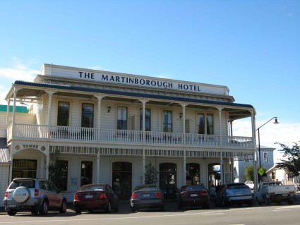
From Putangirua I drove to the popular little town of Martinborough. This, the main hotel on the tree filled square, is a typical balconied and decorated building in this pretty place. Sadly, we will miss the festival here in early March as we want to be in Auckland shortly afterwards for the Pasifika Arts Festival, so I was glad to stop and look around for a wee while.
| Places and people |
|
13/02/2008
In winter, presumably, the water fills much of this gorge. You wouldn't walk this way with any risk of a flash flood.
| Places and people |
|
13/02/2008
Aotearoa is in the grip of a drought. The headlines are full of falling reservoirs and potential water restrictions.
For us, we seem to be bringing rain to parched landscapes almost everywhere we go. It rained really heavily last night, but obviously not enough to provoke this stream to full flood.
| Places and people |
|
13/02/2008
From the lookout you clamber down to the stream bed. (Obviously you can do the walk the other way but I did the easier climb.) It's then maybe 300 or 500 metres up to the base of the pinnacles, offering an even more astonishing image.
That stretch was the hardest slog of the whole walk, as there's no shade in the stream bed during the day, and the shale slips away from your boots, needing constant attention and strong muscles.
| Places and people |
|
13/02/2008
These pinnacles are formed from the soft gravels of the area. They are 12-14 million years old, and over the millennia, the river Putangirua has eroded deep gullies ('badlands) down which the rain pours, washing away the gravel. Large boulders shed the water, and protect the gravel immediately below them, creating these pinnacles. When they lose the capping rock (as many have), they erode quickly.
I climbed up the 'bush track', about a n hour of fairly steep going, climbing maybe 100m. At the top a look out has been built off the cliff, providing this splendid view.
| Places and people |
|
13/02/2008
The Maori name for New Zealand means Land of the Long White Cloud, and here is the suspended precipitation strutting its stuff. Some argue that the country should formally change its name (back) to Aotearoa; others oppose that idea. It would put NZ ahead of Australia in all the Olympic/World Cup parades!
This is taken from a look out in the bush walking into the Aorangi hills from the site. The headland under the clouds is Turakirae Head, the toe of the Rimutaka Range. On the far side lies Wellington.
| Places and people |
|
12/02/2008, Putangirua Pinnacles
The southernmost DOC site on the North Island is at Putangirua Reserve. Here is Puff under the cliffs that tower above the river in the campsite, just off the road.
There was a strong breeze blowing from the south, so we actually spent the night tucked away behind some bushes, and even so we shook occasionally in the wind.
There were only two other vans in the site, and in fact they were the only two I'd seen after turning off the main road at Featherston.
| Places and people |
|
12/02/2008, Lake Wiararapa
For a few days we decided to have separate adventures. Pip is spending a few days with her mother, so Beryl gets her to herself for once. In the meantime Sarah is exploring the area known as the Wairarapa, after the large lake at its centre. Pip knows the area well; it's Wellington's playground, known as 'over the hill' all of her life.
Tuesday afternoon was pretty gloomy, with racing clouds and quite a breeze kicking up across the water as I stood on the western shore.
| Places and people |
|
11/02/2008, Cook Strait
These cattle and sheep were travelling with us, fairly undisturbed (but we had a very quiet passage.
With a van, Bluebridge is significantly cheaper than the competition.
| Places and people |
|
11/02/2008, Picton & Queen Charlotte Sound
We tore ourselves away from Mel and Michelle's fabulous hospitality on Saturday. That night we stopped at Pelorus Bridge, an old favourite of Pip's. It is the site of a bridge across the Pelorus, historically a major obstacle on the road between Nelson and Picton. Now there is little there except a café, and extensive DOC camping availability, surrounded by walks of all grades into the bush.
Pelorus was the sailing vessel that explored these parts, and thus this useful pre-chronometer instrument is honoured. Funnily enough, in the Tasman the French ship Astrolabe lent her name to several geographical features. Rather prettier than calling the headland off which you've marked a waypoint GPS Cape.
On Saturday we did several of the shorter walks, which were great. We planned to do the longer walk (and remember the camera) on Sunday morning, but woke up to torrential rain. Standing-under-the-hosepipe rain, so we abandoned that plan.
Instead we drove on to Picton and met up with Milly, the other owner of the van. Her pals Helen and Mary kindly invited us to join their Sunday night BBQ, which was great fun.
The pic is the Queen Charlotte Sound as we steamed north. We consoled ourselves with the thought that we will be coming back in a few weeks, not least to return Puff to Milly.
| Places and people |
|
In the evening Peter Bethune, the man behind Earthrace, was speaking just down the road. We stopped en route for sushi on the beach in the wonderful sunshine.
Peter himself was interesting, with lots of headbanger stories about his world record attempts in his spectacular power boat. We (Pip and Sarah) are a bit sceptical, because the habitat loss, deforestation and loss of valuable agricultural land to the biofuel demand is itself unsustainable and ecologically damaging. The answer must rely on less damaging sources of energy and reducing reliance on oil type fuels.
| Places and people |
|
We motored up to Marahau, on the edge of the wonderful Abel Tasman National Park, and did the first short section of the walk to Tinline Beach. It was amazingly busy, but has inspired Sarah to seriously consider a long tramp as part of this trip.
| Places and people |
|


