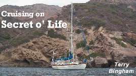
Profile
Who: Terry Bingham
Port: Eagle Harbor, WA USA
Favorite links
28 May 2008
20 March 2005
20 August 2004
22 April 2002
16 April 2002
15 March 2002
25 January 2002
24 November 2001
08 October 2001
09 March 2001
04 January 2001
30 November 2000
12 October 2000
29 September 2000
11 August 2000
10 August 2000
09 July 2000
06 July 2000
28 May 2000
04 May 2000
North along the Clipper route
22 April 2002
Terry Bingham
I've been running all over Zihuatanejo doing those last minute things required prior to a long voyage. I checked out with the Port Captain on Friday, so I'm legal to leave the country, and I'm looking to haul anchor late afternoon and take advantage of the wind that usually builds and carries into late evening. In my opinion, long ocean passages require several things: adequate provisions for 50% longer than the estimated passage time; ditto for water; full fuel tanks and reserves in jerry cans if there's room; a vessel capable and prepared for the intended voyage - and a positive mindset amongst the crew. These last two topics go hand in hand, for the captain and crew of the vessel must have total confidence in the reliability and capability of the vessel to endure any challenges that may be encountered in order to insure their own comfort, safety and belief in a successful passage. There are countless stories of voyages resulting in tragedy when the crew lost that confidence in their vessel and abandoned - many never to be seen again. In almost all cases, when the chicken feathers hit the fan, the crew could wedge themselves into a corner and let the boat tend to herself, and the result would be positive. Once again, the old cliche: "Never leave your vessel until you have to step UP into the liferaft."
And one other, "Be careful what you wish for." We were nine days out of Zihuatanejo and I was remembering the previous eight. Only one day had seen over one hundred miles and on several occasions I had run the engine for two or three hours to charge the batteries AND move us along on oily slick seas. It was now blowing 18 knots and I was reefing the main in anticipation of what looked like an increase coming. I thought more than once about the times in the past few days I'd "wished for more wind" and wondered just how much of that wish would be granted. The answer to that would take many more days coming, but I would get the answer eventually.
When I plotted this course, oftentimes referred to as the "Clipper Route", since it was supposedly used to go north in the 1800s by the square-riggers whose capability to make progress to windward was limited, I accepted the fact that we would actually have to head somewhat south for the first few days, since the prevailing winds along the Mexican coast are northwesterlies, and to make any progress north would require beating hard into them. So, on that Monday evening leaving Zihuatanejo, I wasn't too concerned about our heading when I realized the best we could do was southwest. Looking back on those days brought memories of drifting along at under 2 knots and working several hours in the middle of the nights trying to eek out another half knot or at least stay on course. Because the passage was so long, thirty-five hundred miles at least, I was reluctant to burn much fuel since I knew there would be times further north when we would have to motor. Still being in the tropics, the days were hot and the nights comfortable, but I noted a slow decline in the water temperature and this began to have the effect of progressively bringing the nighttime temps down, which I realized would soon carry through to the days - especially when we began to encounter overcast. On day six I noticed that the refrigerator wasn't keeping it's normal temperature, although the compressor was running and everything looked OK - it just wasn't making cold. Having no way to check it or deal with it, I shut it down and moved most perishables down in the bilge where they would be kept at water temperature, now below 70 degrees and falling fast. The four pounds of aracherra - marinated flank steak - I made into a stew, which I then kept sealed in the pressure cooker, reheating it to take a serving and then bringing it to pressure and leaving it sealed until the next meal. The cheeses and yogurt kept in the bilge would last the entire voyage.
It was now day ten and the wind was starting to settle in at a comfortable 15 knots, when early in the morning I had the unique experience to make contact on the VHF with the vessel "Fantasea", located in Cabo San Lucas some 375 miles north of our position. Normally, VHF is good for 30 - 50 miles at the most, but on occasion an atmospheric "skip" allows more distant contact. Through "Fantasea" I was relayed a message from friends aboard "Synchronicity", another sailboat that had left Cabo that morning and was setting out for Vancouver, BC via the Clipper Route. Maybe we would actually be able to rendezvous mid Pacific? This route would take us up to 1000 miles off the coast of California, hopefully with nice northeasterly winds and then place us near the Pacific High Pressure Center around which, depending on it's location, we would venture the west side or east side for more favorable winds going north. Once past the high, we could expect northwest winds and bear off on a comfortable reach, "Secret O' Life" heading for Newport, OR while "Synchronicity", with a family of four aboard who had just recently finished a world circumnavigation, would head further north to Cape Flattery, WA and the Strait of Juan de Fuca. At the least, I was looking forward to being close enough to them at some point that we could pass messages via the VHF.
Later that same day, after taking a reef in the main with the wind now a steady 25 knots, I sighted Isla Clarion, the furthest west of the Mexican islands, and passed within three miles on the windward side in seas approaching eight feet. I guess I was getting my wish for wind as we would do 144 miles in the next 24 hours - a very good day! After being offshore for ten days, approaching Clarion (which reminded me so much of Molokai in the Hawaiian chain) brought butterflies to my stomach, since out here one worries not so much about the ocean as about land and potential grounding. Several scenarios played through my mind: what if we lost steering right now? What if a sail were to blow out? We'd be blown onto the rocky shore for sure! Once past the island, I began to settle down knowing it would be weeks before the dangers of land would once again be present off the bows.
Day 11 brought more wind, keeping us in a reefed condition, and it also brought the cold. I dug out polarfleece pants, a sweatshirt and something I hadn't worn in a long time - socks! We were consistently moving along above 7 knots, about the limit for my comfort level. "Secret O' Life" has a theoretical hull speed of only 7.4 knots, so things start to get a little squirrely as we approach that speed and I prefer, especially when on passage, to keep it at 7 or a little under. This day also saw us cross our westbound track to Hawaii of May, 2000! As I reviewed the log, I noted conditions were about identical at this spot on that voyage and it had been ten days later in May. Pretty consistent out here along latitude 20N. Later on I heard a crystal clear call from USCG in Los Angeles on the VHF. There has to be almost 900 miles between us!
We flew along during the next week as we made progress in latitude to the North, but also sliding further West in longitude. Four days above 135 miles, and three days above 145 ! The comfort level was OK though, as we had been constantly on starboard tack which allows a little easier use of the galley. To pass the time I was reading a bit, maintaining a watch on the horizon as I could, downloading weatherfaxes from the short-wave radio to the computer and listening to a couple H-F nets. "Synchronicity" was checking in daily on the Seafarer's Net, so I was able to keep track of their position. I was staying about two days ahead of them and they were parallel to my track so I didn't suppose we would make contact any time soon.
Days 19, 20 & 21 saw the mileage drop a bit into the 110 - 120 range and from the latest weatherfax I knew we were approaching the Pacific High. Trouble is, that thing moves around all the time, and if it wants to move 600 miles in one day, no problem. So one questions the usefulness of these tools when the boat can only do at best, 145 miles in a day, but they are good for planning and once the weather systems settle in for the summer, they are much more consistent and stable. It was still getting colder and now most of the day was overcast, sometimes with a small rain storm moving through, so I spent an afternoon recommissioning my propane fired bulkhead heater, an item I'd seen no use for in the past three years! Late in the night on day 20, our speed dropped below 2 knots and I invested the next 17 hours in diesel burning to find enough wind to keep moving. This is a classic situation in crossing the high - at some point you motor for a day or two, or drift for several days waiting for the high to reposition and allow some wind your way. At this time the Pacific was all it should be: calm and deep blue with not a cloud in the sky.
Just wait and it will change, I thought. Late on day 21 and all through day 22 it was back to squally, rainy weather with winds in the high teens and low twenties, making for a little less comfort than the previous days. A lot of sail changing takes place in this kind of weather and it seems I was always putting in or shaking out a reef or rolling the Yankee in or out. Then on the morning of day 23, there was no wind and we were motoring again. Midmorning I saw the first traffic since a small fishing boat on day 3! A large tanker heading west and when I called him on the VHF he advised they were enroute Long Beach to Korea. At three that afternoon a westbound Nissan car carrier appeared and I called him up to inquire about weather. He said they had just gotten out of a gale in the last 12 hours and that agreed with what I saw on the weatherfax. At least that storm was east of us and would cause no problems. By 6 p.m. there was enough wind to make 4 knots so I shut down the engine and enjoyed the quiet evening.
At 1 a.m. I was on deck putting a reef in the main with wind to 20 knots, but by 6 a.m. it was backing off again and clouds were rolling in. Late that afternoon we'd had a couple rainy squalls and I determined we had just crossed our eastbound Hawaii - San Francisco track from July, 2000. It reminded me that nearby was where we endured a two day gale on that passage and I thought the weather today looked a lot different from two years ago. "Synchronicity", according to their roll call check in, was still 150 miles behind us, too far for the VHF. It had been almost three weeks since I'd talked with anyone and it would have been nice to be able to raise them.
The next two days provided about the same - mediocre wind and cloudy with a drizzle now and then - and it was getting even colder! But then, the afternoon of day 25 found me reading in the cockpit in shorts. How changeable this Pacific weather can be. That evening, a weatherfax showed a sizable low west of our position building strength with the probability of developing gale winds. Comparing it's position with ours and our planned track, it looked as if the system would pass safely to the SW of us and we should see some northwesterly winds in a day or so. Early morning of day 26, the wind shifted quite a bit causing a changeover to port tack for the first time in weeks and I started a schedule of weatherfaxes three times a day. By midmorning we were back to starboard tack with a reef in the main and by noon a few rain squalls had blown through and a huge patch of blue sky was visible to the West. We were encountering at least three different swell patterns, making it a little rolly, and indicating some different weather nearby.
At 5:30 that afternoon I put the third reef in the main and estimated the southeast winds were 25 to 30 knots with a building swell. A new weatherfax that night showed the low, with a full gale blowing on it's west side had now changed it's southeasterly course and would head directly east over our position in the next 24 hours! Like I've said before, what can you do when the weather moves at 40 knots and the boat moves at 6? All through that night and the entire next day it rained, and it blew 30 and 35 knots, gusting 40 I'm sure. It was south and southeast, so to try and hold our course anywhere near Newport required staying fairly close to the wind, not the most comfortable tack in these conditions. But constantly pounding, taking the 6' and 8' seas on the port forequarter, "Secret O' Life" went on through it all - and I stayed below, wedged into the dinette, and tried to read and continued to download weatherfaxes that showed me things I really didn't want to know. And I was concerned for "Synchronicity" because from their position I knew they were closer to the "bad side" of the low and were probably encountering seas three times the size of the eight footers we were battling and their course would keep them in the low longer than us, as we had already begun to head more easterly toward Newport. It was while looking at the weatherfaxes that I noticed there was no high pressure in the eastern Pacific at all. I had never seen this before, but the high had completely disappeared over the past 24 hours, to allow this low and another behind it to dip much lower than usual. In fact the high seas and most of the wind from this low would go on in the next few days to hit the coast of California from the Oregon border to Point Conception with high winds and huge surf. It was truly an anomaly, and now I was seeing that the lowest pressure center of the low was going to not only head east with us, it would be curving north and staying right with us at least for another 12 to 18 hours! Oh joy!
So on the morning of day 28 with only 75 miles to go into Newport, after seeing the wind moderate to the low twenties around 0300 hours, allowing us to go back to the second reef for a while, I was once again on deck in the chilling spray, putting in that third reef as we pressed on into six foot seas trying to complete this passage. For several hours it blew 30 and 35 knots, but by noon, the wind was down to 20 and the sky was clearing. By 2 p.m. we were flying full sail with nothing but blue sky and the Oregon coast range mountains in the distance. High tide and slack current would coincide with our estimated arrival time in Newport, so we forged on ahead, making the sea buoy at the Yaquina River entrance at 2230 hours, May 20, just 28 days, 4 hours after hauling the anchor in Zihuatanejo. We had covered 3250 miles in a total time of 676 hours, 611 under sail and 65 motoring. Friends I have talked with about returning from Cabo San Lucas, at the tip of Baja, to southern California speak of 150 or 200 hours of engine time bashing into 30 knot headwinds and that's a 1000 mile trip!
We're now quietly moored in the marina in Newport where the long list of projects will be whittled down over the next few months. I'll spend a majority of my time in Bend, but will return to the boat regularly to prepare for the next passage. Where? I'm not sure - there's no schedule. Maybe back to Mexico for another season or off to Hawaii and the South Pacific and Indonesia. Ecuador and Chile have always held my interest and could be attained by continuing south from Mexico. Check back and see what happens.
Fair Winds - - Terry and Secret O' Life
Comments
| Vessel Make/Model: | Union 36 Cutter |
| Hailing Port: | Eagle Harbor, WA USA |
| Crew: | Terry Bingham |
| About: | Tammy Woodmansee spends as much time as she can on the boat, but returns to the states from time to time for work to pad the travel kitty. Terry single-hands when she's not aboard. |
| Extra: | CURRENT LOCATION: January, 2007 - cruising the west coast of Costa Rica. |
| Home Page: | http://www.sailblogs.com/member/secret/?xjMsgID=3739 |
Gallery not available
Profile
Who: Terry Bingham
Port: Eagle Harbor, WA USA