D & D Nagle aboard MV DavidEllis
25 August 2022
27 May 2020 | Elfin Cove, SE Alaska
16 April 2020 | Elfin Cove, Cross Sound, Chichagof Island, SE Alaska
10 July 2019 | Elfin Cove, Alaska (or in Aussie:
18 March 2019
19 September 2017 | northbound Verney Passage, west side Gribbell Island
30 May 2017 | Photo is Meyers Chuck, north of Ketchikan AK
22 February 2017
29 August 2016 | on-the-hard, Wrangell
19 November 2015 | almost there
16 November 2015
15 November 2015
11 November 2015 | Shearwater - Bella Bella, BC
10 November 2015 | photo is approaching Bottleneck Inlet
07 November 2015
01 November 2015 | Wrangell, Alaska
17 September 2015 | Juneau to Petersburg
19 July 2015 | Wrangell > Petersburg > Tracy Arm > Juneau
28 June 2015 | Wrangell, AK (still on the hard)
03 March 2015 | Ketchikan
Days 17-19
19 November 2015 | almost there
Day 17: Port Neville, Seymour Narrows, to Campbell River
Before getting into Day 17s run, I'd like to share some thoughts on Inside Passage dock ramps. The first thing to know is that the tidal height differences -- high tide to low -- are significantly larger than those on the outside coast; two times or more larger. 18-20 foot changes in 6 hours are not uncommon in SE Alaska and a real factor in deciding where and how to anchor the boat. For example, a nice 40' anchorage with a rock in it 25' deep at high tide, will be touching the bottom of DE (with 6' draft) at low tide.
But I didn't bring this up, to talk about anchoring; I want to talk about dock ramps -- a simple structure, connecting the land ashore to the floating dock where the boats are tied. On a very high tide, the ramp may be nearly level. Somewhere back in the blog is a photo taken at Seahorse Marine, on the Pearl River in DouMen, China, just after a typhoon, where the storm surge flood brought the river so high that in the boat tied to the finishing dock, we are looking down at the shore. The dock is actually floating higher than the shore and the angle between dock and shore has been reversed. But that situation was an exception. The everyday reality of going to shore, or coming back to the boat is that from one tide to another the angle of the ramp increases and decreases from nearly level to very steep. How steep depends entirely on how long the ramp is.
In order to "see" this you may need to draw it, but for any given height difference (between shore and dock) the shorter the ramp, the steeper the angle between land and float. Make the ramp longer, and the angle between the floating dock and shore will be less steep.
In practical everyday usage, it would be nice to schedule having to haul a couple of stuffed duffle bags of laundry up the ramp at high tide (when there's very little incline) or bring groceries back to the boat, with gallon jugs of water, a case of beer or other cruising supplies when the ramp is not so steep that a dock cart can get out of control going down the ramp. The reality is, you get what you get as life, human life at least, is not scheduled around the height of the tides.
One other factor about ramps before getting into the story -- ramp surface. Most new ramps are constructed of metal -- aluminum or galvanized steel -- and the walking surface may be some kind of patterned rubber or painted-on non-skid. Some ramps have very aggressive metal teeth that unless completely iced are nearly impossible to slip on -- the dogs hate these as you might imagine; they pick their way up or down such a ramp, one paw at a time, a grim, fixed expression on their face, and in my mind, I can hear them planning how they're going to get even with me, should they actually survive going to the shore and back to the boat on this m@&$#r-f*^€£ing ramp! Meyers Chuck has such a ramp, as does Baronoff Warm Springs (I think). In 2009 when we arrived in Dutch Harbor to clear US Customs, coming from Hong Kong, not only was the ramp of this type but the entire 1000 foot float. Little puppy Rusty took two steps, looked up at me with wide-eyed shock, horror and disbelief that I would torture him in this way and refused to take another step. I had to carry him the several hundred yards to shore and back.
Most other ramps are not nearly so aggressive as the expanded steel teeth, in their anti-slip methods; many have ladders/steps built into the ramp floor, off to one side for when the tide makes the ramp especially steep and/or slippery from weather.
But then there are the older wood-decked ramps. Have I mentioned it rains a lot up here? And when wood stays wet much of the time it grows algae and other scummy coatings which are -- you guessed it -- slippery! Add to that, nearly freezing temps and we arrive at the story I wanted to tell you. Is anyone still with me?
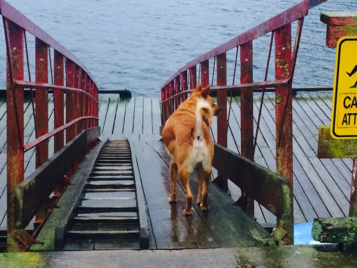
Port Neville is an old place, which is not really a place anymore. Years ago there was a general store and a post office here (the post office actually still functioned on a limited basis until closing about 5 years ago. Dorothy had one of the last card/letters franked there, when we stopped at the end of one cruising season.) The old dock, ramp and pier are still functional, but dated, and the ramp is somewhat shorter than a newer one might be, given the height change in tides here. The photo above shows Rusty headed down the ramp at about a 30 degree angle, not unusual for low tide anywhere. And you can see the ladder structure, to the left, on the wood deck of the ramp.
The night of 15 Nov, the day we arrived at Port Neville, the tide tables tell me the low tide was minus 1 meter (yes Bunky, that's a meter, not feet, the rest of the world measures stuff in meters, get used to it) at 2200 hrs on a new moon, making the total high-to-low tidal difference 5.6 meters (okay you pathetic putz, I'll do the math for you, that's an 18.4 foot difference!) and the ramp, when Dot and I took the Rs to shore for p&p, was at least a 60 degree incline! The only way we could get up it was a slow careful climb up the ladder side of the ramp, Rusty behind me on lead, Rascal behind Dorothy. Both the dogs tried climbing the ramp without the ladder and could not, even though they're four-pawed, maintain traction. We came back down, much the same way, facing into the ramp, climbing down the ladder, keeping each dog in front of us on the ladder.
The night of the 16 Nov, our second at Port Neville, the tide table says the low tide was at 2300 hrs and was even lower at -1.1 meter. It wasn't quite that late though when we took the dogs to shore and the ramp was more like 45 degrees than the boggling 60 of the night before. Dot and I still used the ladder, but the dogs, with their greater traction struggled up the slick ramp. On returning to the boat, I didn't want the boys to use the slick side of the ramp and tried to keep them on the ladder, but they were off lead, and Rascal waits for nothing and no one and went off the ladder onto the flat surface. From my point of view on the ladder above him, Rascal slid on his butt the 30 or so feet to the float. Wade, who happened to be on DE's deck, says the boy went down stiff-legged on all fours. Either way, I wish I could've seen his face; but his body language made it clear that his slide-for-life wasn't what the little Rascal expected. We checked his paws for slivers, and I was grateful he hadn't caught a leg in the vertical structure at the side of the ramp. Absent injury, it was pretty funny. The following morning, Day 17, going to shore off lead, Rascal ran up to the ramp, stopped, looked... and moved over to the ladder side before heading up to the beach.
and so, back to Day 17: we had an easy start with relatively flat water and light wind from aft. The wind built though, up to the forecast 35 knots, and that against current made for rough surface waters. We had it pretty easy, just bouncing around a bit. The few vessels we same coming up the channel, with the current mind you, were entirely enveloped in spray every 30 seconds or so. Certainly not the most comfortable boat ride.
That running against the current thing meant for us, doing less than 2 knots at times (at 1900 rpm) in Race Passage. Through the day's passage, we were on, off and on again for making the 1600 slack through Seymour Narrows. We did finally run through without drama, just past sunset and about 45 minutes after slack. For their own amusement, the gods littered the last couple miles of approach to the narrows with logs, trees, stumps, sticks and deadheads.
And then, pretty much anti climatically, we were back in civilization, with structures and lights all along the shoreline. We nosed into one of the harbors at Campbell River, tying up at the transient dock with a bright red pub sign shining down upon us from shore.
Day 18: another 0430 wake-up and pre-dawn departure. What marked this day was the hours long, 180 degrees of brilliant orange, pink and red dawn. Light winds from aft and smooth waters marked the run down to Nanaimo. And to cap off the day, just before entering the harbor proper, we had a pod of humpbacks breaching less than a mile away.
We tied up at G dock, directly in front of the wharfinger's office, downtown Nanaimo, about 1600 hrs. People we saw on the promenade and on the street were all noticeably dressed far more fashionably than the SE Alaska chic of sweatpants and Extra-Tufs (boots) that we've become accustomed to. The marina slips here, as they were in Campbell River, were mainly filled with sailboats and power yachts, rather than the fishboats and workboats which with we feel comfortable. The ever-lovely Ms Nagle made a bee-line for a yarn shop the wharfinger recklessly mentioned to her (I shall have to deal with him later), and the boys did the usual in a greenway along the waterfront.
Day 19: after a very fine breakfast bagel from a shop just off the waterfront, we departed Nanaimo amid a brisk (forecast) breeze from the north, brilliant sunshine and suicidal seaplanes. It was enough to cause me to check my rules of the road and seaplanes do not have precedence over power vessels! Has no one explained the "lug nut rule" to these guys? An hour out of Nanaimo is Dodd Narrows a short but quite narrow passage which requires awareness of tide state and opposing traffic. In our case, the tug Inlet Ranger was just entering the other side of the passage towing a log boom. After an exchange on the radio, DE made circles outside for 20 minutes while the tug and its load came through. A working anachronism, most people have never and will never see. The wait was well worth it. A short while later, we paralleled another tug and log boom. In this case the majority of the tow was white with birds hitching a ride on the tow.
Approximately 1400, MV DavidEllis crossed back into US waters. Lots of boat and ship traffic in these waters: Canadian Coast Guard buoy tender doing some kind of exercise with a 47' Motor Life Boat and a AS Dauphine Helo. But the capper at the boundary was a mob of marine mammal (as opposed to helo) dolphin rushing to ride our bow wave.
We should be clearing Customs at Friday Harbor in the next hour. I'm going to close this out and will finish up after we make it to Seattle.
Before getting into Day 17s run, I'd like to share some thoughts on Inside Passage dock ramps. The first thing to know is that the tidal height differences -- high tide to low -- are significantly larger than those on the outside coast; two times or more larger. 18-20 foot changes in 6 hours are not uncommon in SE Alaska and a real factor in deciding where and how to anchor the boat. For example, a nice 40' anchorage with a rock in it 25' deep at high tide, will be touching the bottom of DE (with 6' draft) at low tide.
But I didn't bring this up, to talk about anchoring; I want to talk about dock ramps -- a simple structure, connecting the land ashore to the floating dock where the boats are tied. On a very high tide, the ramp may be nearly level. Somewhere back in the blog is a photo taken at Seahorse Marine, on the Pearl River in DouMen, China, just after a typhoon, where the storm surge flood brought the river so high that in the boat tied to the finishing dock, we are looking down at the shore. The dock is actually floating higher than the shore and the angle between dock and shore has been reversed. But that situation was an exception. The everyday reality of going to shore, or coming back to the boat is that from one tide to another the angle of the ramp increases and decreases from nearly level to very steep. How steep depends entirely on how long the ramp is.
In order to "see" this you may need to draw it, but for any given height difference (between shore and dock) the shorter the ramp, the steeper the angle between land and float. Make the ramp longer, and the angle between the floating dock and shore will be less steep.
In practical everyday usage, it would be nice to schedule having to haul a couple of stuffed duffle bags of laundry up the ramp at high tide (when there's very little incline) or bring groceries back to the boat, with gallon jugs of water, a case of beer or other cruising supplies when the ramp is not so steep that a dock cart can get out of control going down the ramp. The reality is, you get what you get as life, human life at least, is not scheduled around the height of the tides.
One other factor about ramps before getting into the story -- ramp surface. Most new ramps are constructed of metal -- aluminum or galvanized steel -- and the walking surface may be some kind of patterned rubber or painted-on non-skid. Some ramps have very aggressive metal teeth that unless completely iced are nearly impossible to slip on -- the dogs hate these as you might imagine; they pick their way up or down such a ramp, one paw at a time, a grim, fixed expression on their face, and in my mind, I can hear them planning how they're going to get even with me, should they actually survive going to the shore and back to the boat on this m@&$#r-f*^€£ing ramp! Meyers Chuck has such a ramp, as does Baronoff Warm Springs (I think). In 2009 when we arrived in Dutch Harbor to clear US Customs, coming from Hong Kong, not only was the ramp of this type but the entire 1000 foot float. Little puppy Rusty took two steps, looked up at me with wide-eyed shock, horror and disbelief that I would torture him in this way and refused to take another step. I had to carry him the several hundred yards to shore and back.
Most other ramps are not nearly so aggressive as the expanded steel teeth, in their anti-slip methods; many have ladders/steps built into the ramp floor, off to one side for when the tide makes the ramp especially steep and/or slippery from weather.
But then there are the older wood-decked ramps. Have I mentioned it rains a lot up here? And when wood stays wet much of the time it grows algae and other scummy coatings which are -- you guessed it -- slippery! Add to that, nearly freezing temps and we arrive at the story I wanted to tell you. Is anyone still with me?
Port Neville is an old place, which is not really a place anymore. Years ago there was a general store and a post office here (the post office actually still functioned on a limited basis until closing about 5 years ago. Dorothy had one of the last card/letters franked there, when we stopped at the end of one cruising season.) The old dock, ramp and pier are still functional, but dated, and the ramp is somewhat shorter than a newer one might be, given the height change in tides here. The photo above shows Rusty headed down the ramp at about a 30 degree angle, not unusual for low tide anywhere. And you can see the ladder structure, to the left, on the wood deck of the ramp.
The night of 15 Nov, the day we arrived at Port Neville, the tide tables tell me the low tide was minus 1 meter (yes Bunky, that's a meter, not feet, the rest of the world measures stuff in meters, get used to it) at 2200 hrs on a new moon, making the total high-to-low tidal difference 5.6 meters (okay you pathetic putz, I'll do the math for you, that's an 18.4 foot difference!) and the ramp, when Dot and I took the Rs to shore for p&p, was at least a 60 degree incline! The only way we could get up it was a slow careful climb up the ladder side of the ramp, Rusty behind me on lead, Rascal behind Dorothy. Both the dogs tried climbing the ramp without the ladder and could not, even though they're four-pawed, maintain traction. We came back down, much the same way, facing into the ramp, climbing down the ladder, keeping each dog in front of us on the ladder.
The night of the 16 Nov, our second at Port Neville, the tide table says the low tide was at 2300 hrs and was even lower at -1.1 meter. It wasn't quite that late though when we took the dogs to shore and the ramp was more like 45 degrees than the boggling 60 of the night before. Dot and I still used the ladder, but the dogs, with their greater traction struggled up the slick ramp. On returning to the boat, I didn't want the boys to use the slick side of the ramp and tried to keep them on the ladder, but they were off lead, and Rascal waits for nothing and no one and went off the ladder onto the flat surface. From my point of view on the ladder above him, Rascal slid on his butt the 30 or so feet to the float. Wade, who happened to be on DE's deck, says the boy went down stiff-legged on all fours. Either way, I wish I could've seen his face; but his body language made it clear that his slide-for-life wasn't what the little Rascal expected. We checked his paws for slivers, and I was grateful he hadn't caught a leg in the vertical structure at the side of the ramp. Absent injury, it was pretty funny. The following morning, Day 17, going to shore off lead, Rascal ran up to the ramp, stopped, looked... and moved over to the ladder side before heading up to the beach.
and so, back to Day 17: we had an easy start with relatively flat water and light wind from aft. The wind built though, up to the forecast 35 knots, and that against current made for rough surface waters. We had it pretty easy, just bouncing around a bit. The few vessels we same coming up the channel, with the current mind you, were entirely enveloped in spray every 30 seconds or so. Certainly not the most comfortable boat ride.
That running against the current thing meant for us, doing less than 2 knots at times (at 1900 rpm) in Race Passage. Through the day's passage, we were on, off and on again for making the 1600 slack through Seymour Narrows. We did finally run through without drama, just past sunset and about 45 minutes after slack. For their own amusement, the gods littered the last couple miles of approach to the narrows with logs, trees, stumps, sticks and deadheads.
And then, pretty much anti climatically, we were back in civilization, with structures and lights all along the shoreline. We nosed into one of the harbors at Campbell River, tying up at the transient dock with a bright red pub sign shining down upon us from shore.
Day 18: another 0430 wake-up and pre-dawn departure. What marked this day was the hours long, 180 degrees of brilliant orange, pink and red dawn. Light winds from aft and smooth waters marked the run down to Nanaimo. And to cap off the day, just before entering the harbor proper, we had a pod of humpbacks breaching less than a mile away.
We tied up at G dock, directly in front of the wharfinger's office, downtown Nanaimo, about 1600 hrs. People we saw on the promenade and on the street were all noticeably dressed far more fashionably than the SE Alaska chic of sweatpants and Extra-Tufs (boots) that we've become accustomed to. The marina slips here, as they were in Campbell River, were mainly filled with sailboats and power yachts, rather than the fishboats and workboats which with we feel comfortable. The ever-lovely Ms Nagle made a bee-line for a yarn shop the wharfinger recklessly mentioned to her (I shall have to deal with him later), and the boys did the usual in a greenway along the waterfront.
Day 19: after a very fine breakfast bagel from a shop just off the waterfront, we departed Nanaimo amid a brisk (forecast) breeze from the north, brilliant sunshine and suicidal seaplanes. It was enough to cause me to check my rules of the road and seaplanes do not have precedence over power vessels! Has no one explained the "lug nut rule" to these guys? An hour out of Nanaimo is Dodd Narrows a short but quite narrow passage which requires awareness of tide state and opposing traffic. In our case, the tug Inlet Ranger was just entering the other side of the passage towing a log boom. After an exchange on the radio, DE made circles outside for 20 minutes while the tug and its load came through. A working anachronism, most people have never and will never see. The wait was well worth it. A short while later, we paralleled another tug and log boom. In this case the majority of the tow was white with birds hitching a ride on the tow.
Approximately 1400, MV DavidEllis crossed back into US waters. Lots of boat and ship traffic in these waters: Canadian Coast Guard buoy tender doing some kind of exercise with a 47' Motor Life Boat and a AS Dauphine Helo. But the capper at the boundary was a mob of marine mammal (as opposed to helo) dolphin rushing to ride our bow wave.
We should be clearing Customs at Friday Harbor in the next hour. I'm going to close this out and will finish up after we make it to Seattle.
Comments
| Vessel Name: | DavidEllis |
| Vessel Make/Model: | Diesel Duck 462 (Seahorse Marine) |
| Hailing Port: | Sebastopol, CA, USA |
| Crew: | Mike (Dave) and Dorothy Nagle |
| About: | |
| Extra: |
Gallery not available
Who: Mike (Dave) and Dorothy Nagle
Port: Sebastopol, CA, USA
SailBlogs Friends
