Sherpa
22 March 2012
13 March 2012
13 March 2012
13 March 2012
12 March 2012
29 August 2011
29 August 2011
29 August 2011
29 August 2011
05 April 2008
24 April 2006
23 April 2006
22 April 2006
21 April 2006
20 April 2006
19 April 2006
Sailing Turkey's Southern Aegean Coast -- Sept 2011
12 March 2012
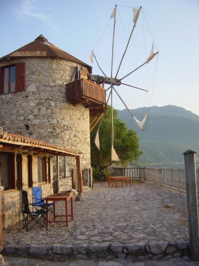
Photo: Stone windmill with sails at Kormen Harbor
Setting out!
After several daysails from Didim Marina and overnights anchored in the coves of nearby Gulluk Korfezi (Gulluk Gulf), we were feeling fairly comfortable sailing our newly purchased boat "Sherpa" -- having anchored, motored into and out of our slip at the marina, tried out the various combinations of sails (main, genoa, and staysail), and practiced reefing the mainsail. We'd also used the Aries wind vane steering, and found it held the boat's course very well, even when sailing close into a fairly strong wind! The boat also has an auto pilot, but unless we're motoring, we prefer to use the wind vane since it doesn't use our precious battery power. And Art had tuned up the Suzuki outboard for the inflatable dinghy so that it now started reliably with only one or two pulls on the starter cord.
We purchased a good set of binoculars (from one of three U.S.-based West Marine stores in Turkey), and a "dongle," which attaches to our computer so that, in theory at least, we can get internet access anywhere that there's a phone signal. Unfortunately, we can't get the Garmin GPS to communicate with our chart-plotting program, so we have to manually input our coordinates on our laptop computer before we can "see" where we are on the chart. We also use the Imray plasticized paper charts in the cockpit and rely on the larger-scale harbor charts in the indispensible Turkish Waters & Cyprus Pilot written by Rod Heikell, a Brit who's been sailing in the Med since the '70s and writing a plethora of delightfully opinionated pilot books.
Following are some excerpts from the "Sherpa" log as we sailed south along the Aegean coast of Turkey from Didim to Knidos, where the Aegean Sea meets the Mediterranean:
Weds., Aug 31: Didim Marina to Yalikavak (15 nautical miles due south) --
Having topped off the four water tanks (100 gallons total), the 43-gallon diesel tank, and the two propane cartridges (camping gas, as it's called here, for cooking), we paid our bill and set sail from Didim Marina, heading due south in a 12-15 knot westerly wind, past the tiny uninhabited Greek island of Farmako. (Virtually all the islands off the shores of Turkey's Aegean and Mediterranean coasts are Greek, and therefore out of bounds for us unless we go through extensive, and expensive, bureaucratic formalities to leave Turkish waters and enter Greek waters.)
Upon arrival at the little harbor town of Yalikavak, we chose an anchorage close to shore in a corner of the scenic bay amidst other boats tied to mooring buoys in 13-14 feet of water. The Pilot calls the holding in this anchorage "indifferent," as we confirmed. After spending the night at anchor, we motored the mile or so into town in the inflatable dinghy. It's an up-and-coming tourist destination, with a large, modern marina and a line of attractive waterfront restaurants. But since this was the 2nd day of the three-day holiday celebrating the end of Ramadan (a month during which devout Muslims neither eat nor drink from sunup to sundown), many of the eateries were closed. When the wind came up and white caps started forming in the harbor, we decided to hightail it back to the boat before it got uglier. The waves came close to swamping the dinghy and we got drenched, but fortunately the water was warm.
Later when I woke from a short snooze in the cockpit, I realized we were dragging anchor and were perilously close to a large metal buoy. We ended up motoring to a different cove in the bay, where we re-anchored amongst a bevy of sailboats and motor yachts. Lesson learned: Even after 24 hours, don't assume that the anchor will necessarily hold.
Fri., Sept 2: Yalikavak to Gumusluk (6 nm in 15-20 knot NW winds with big seas) --
We sailed to the little town of Gumusluk on the western end of the Bodrum peninsula. The harbor entrance looks tricky but we followed the Pilot's advice to stay close to Rabbit Island (site of the ancient town of Myndus) on our way in. When we doused the genoa, the boat rocked so hard that dishes fell out of the cupboard, making a huge mess of broken glass! Lesson learned: Stow dishes more carefully; even Corelle plates are not indestructible.
The harbor was full of charter and private boats, and in most places is too deep to anchor so we went in close to the T-jetty where boats were docked. Ashore is a row of seaside bars and open-air fish restaurants (including one with a book exchange - yay!). There are many Sunsail charter boats here, since it's an easy day's sail from Bodrum, where many charter fleets are based. The bareboat charters all seemed to motor around and around the harbor, apparently waiting their turn (and help?) with anchoring and tying a line to the far shore (or rafting up to the other Sunsail charters).
Sun., Sept 4: Gumusluk to Bodrum (17-mile sail in 15-20 knot N-NW winds) -
Flying just the genoa, we sailed to Bodrum in the northwest corner of the Gulf of Gokova. There's a large marina here, but we chose to anchor out in the large bay in 30 feet of water. The following day we decided to pick up a mooring buoy for visiting yachts when one opened up. In attempting to catch the buoy line, Art dropped the boathook into the sea. A guy on a stinkboat at the next mooring jumped into his dinghy and helped us grab the mooring line, for which we were grateful albeit a bit embarrassed. Lesson learned: When approaching a buoy, drive the boat very slowly so you don't go flying right past it.
We discovered that we had just missed the final night of the International Ballet Festival here in Bodrum -- too bad, especially since one of the featured dance groups, which we knew from seeing life-size posters all around town, was the Washington Ballet! Is this a small world or what? At night the Bodrum anchorage rocks with "music" blaring from a dozen discotheques (including what is reputed to be the largest disco in Europe) lining the shore and going at full blast until 3 am in the morning.
St. Peter's Castle, built by the Knights of Hospitaller in the early 1400s, is the principal tourist attraction here in Bodrum. It now houses the Hall of Underwater Archaeology -- no, the museum isn't underwater, but it houses a fascinating collection of artifacts rescued from sunken shipwrecks dating as far back as the Bronze Age (2500 BC). One of the exhibits is a reassembly of a sunken cargo ship that had been hauling bronze ingots, manufactured glass bits, and thousands of amphorae (large terra cotta jars with stoppers, two handles at the top, and a pointed bottom used for transporting oil and wine). Art said he'd always wondered why amphorae have a pointed bottom, but seeing the reconstructed boat it was clear that this shape allowed the jars to cluster tightly in an upright position as they conform to the curvature of the boat bottom.
Bodrum has a reputation of being something of a Bohemian town. The owner of a dusty computer repair shop told us over tea that "Bodrum isn't Turkey"; he claims that it's completely different, just as NYC isn't like anywhere else in the States. (He'd lived in NYC for several years.) He apparently writes a mathematical/philosophizing blog. As an observant Muslim, he told us that he believes that it's important to always tell the truth. When his then-wife asked him if he truly loved her, he said he liked her well enough but wouldn't miss her that much if she weren't around. She divorced him forthwith.
Thurs., Sept. 8: Bodrum to Cokertme (20 nm in 8-12 knot SW winds) --
With the winds from astern, we sailed wing-and-wing (one sail out to each side of the boat) using the genoa and staysail. As we sailed into the harbor, we were met by gesticulating touts in motorboats, each trying to attract us to their jetty and restaurant. We chose one at random, and as we approached the quay to tie up, we were thrown the end of the laid-line (an anchored line that holds the boat perpendicular to the jetty, Med-style, in lieu of an anchor).
It's understood that if you tie up at a restaurant dock you're expected to eat at least one meal there, and you can spend the night there for free, usually with water and electricity provided. Dinner at the restaurant overlooking the harbor was a bit overpriced but included a nice selection of "free" mezes. At dinner we met a neighboring boat chartered by two couples (one British and one German) who invited us aboard to taste their apple schnapps, after which they came aboard "Sherpa" to have a look at a classic boat.
Fri., Sept. 9: Cokertme to English Harbor (15 nm in 0-5 knot W winds) --
We sailed to the very pretty English Harbor (west side of Degirman Buku) in fluky westerly winds and big seas. En route we passed a prominent landmark, a new coal-fired power plant, which has been so controversial with locals and conservationists that it hasn't begun operation. We rolled around and the jenny flogged; foresails wing-and-wing also didn't work. Totally frustrated, we changed our destination as we just wanted to "get somewhere, anywhere!" Then I made a mistake entering our GPS coordinates into the chart plotter and we entered the wrong bay -- fortunately we realized our mistake rather quickly when it became obvious that what we were seeing didn't match the harbor sketch in the Pilot.
On our way in to the bay, we saw jelly fish for the first time, and lots of them! But we went on into the little inlet known as English Harbor, which was used as a base by Britain's Special Boat Squadron towards the end of World War II. After two failed attempts, I succeeded in maneuvering the boat so as to allow Art to lower the primary anchor off the bow and then back the boat closer to shore while he rowed the dinghy ashore in order to tie the rear anchor rode to a tree. This was our first attempt at Med-style mooring with a line ashore, and I was glad there weren't lots of neighboring boats being entertained by our obvious inexperience. Some yachters swim their floating anchor line to shore, but Art prefers to stay dry.
Sun., Sept 11 (10th anniversary of 9/11): English Harbor to Cleopatra's Beach (6 nm in 16-20 knot W winds) --
Feeling lazy and not having far to go, we sailed on the genoa alone. Arriving at an anchorage nestled amongst a group of three small islands (Castle, Snake, and Tomb Islands), we anchored in 30 feet of water off Castle Island and spent the night rocking and rolling uncomfortably despite very little wind and smooth seas! Boatloads of day-trippers flock to Castle Island because of its Cleopatra Beach, which according to legend consists of sand that Cleopatra had shipped from north Africa as a gift for her lover Anthony. The sand has been proven to be a type that is not native to Turkey, and part of the sandy beach is now roped off to "preserve" it. The island is also the site of the ancient (pre-Roman) town of Kedreai, and we avoided the noisy throngs of sun-worshipers by wandering through the ruins, including a theatre and part of the defensive wall, situated amid olive groves -- quite lovely!
Tues., Sept 13: English Harbor to Amazon Creek (20 nm in 5-15 kn WNW winds) --
Had a perfectly lovely sail to Amazon Creek in Bodubet Limani. En route we saw our first sea turtle! On our third attempt at anchoring, the anchor finally held. We had a spot at the head of the creek all to ourselves until two other sailboats arrived late in the afternoon.
We walked a long ways down a country lane to find the Amazon Club restaurant (the wrong direction, it turned out), but we backtracked and finally got there under the full moon. It's a truly enchanting little resort with cute rental cabins set along tree-lined, romantically lit walkways. We had an excellent meal at the outdoor eatery: good price, friendly service, and '60s rock music. We liked the whole scene so much that we came back the next morning for a pancake breakfast (and use of their free wifi)! We were short of gasoline for the outboard motor, but it appears we could've brought our dinghy all the way up the creek from the anchorage to the restaurant. We'll do that next time as we'll surely return to this lovely spot.
Wed., Sept 14: Amazon Creek to Cokertme --
We set sail in 7 knots westerly wind but after a couple of long tacks realized that again we weren't making good progress toward Kormen, which was 23 miles due west. When the wind got gusty and the seas grew choppy by early afternoon, we once again decided to change course -- this time, heading north, and ducking back into Cokertme. We then had a wild ride with big waves and 17-20 knot winds, with the genoa reefed (so very easy with roller furling!) so as not to be overpowered. We flew into the harbor under sail and anchored with line ashore. Whew, it's getting easier!
Thur., Sept 15: Cokertme to Kormen Harbor (15 nm) --
The seas were flat calm upon leaving so we motored for an hour or so. The light breeze suddenly increased to12 knots, then 15 knots, then blew from the west at 20-30 knots with big waves and swell -- making for another exciting sail. Kormen Bay is small and there's no room to anchor so we tied up bow-to the quay. Visiting boats share the dock with a ferry boat that runs to and from Bodrum a couple of times each day. There's a wrecked ship half afloat in the harbor, which we were told had been used to smuggle American cigarettes from Bulgaria into Turkey.
Coming into the port, we spotted a lovely old Greek-style stone windmill with cloth sails (see photo above) that was actually turning! That evening we walked along a trash-strewn beach road to get a closer look, and met Orik (a British archaeologist) and his wife Isabelle (a Swiss microbiologist), owners of the beautifully restored windmill and attached home. Orik bought what was left of an old grist mill to save it from being torn down back in the '70s, and over a period of many years, they have lovingly rebuilt it. They invited us in for a tour, and we helped them shut down the windmill for the evening (a fairly elaborate process that entails rolling up each of the large cloth sails in turn). They like to raise the sails whenever there's sufficient wind to turn the windmill although it no longer has any function other to just look beautiful! Orik has also purchased adjoining properties over the years, which are planted in huge tomato farms (which are sharecropped) that are now bright with ripe red tomatos.
Sat., Sept 17: Kormen to Mersincik (8 nm) --
We set sail in very light winds which later picked up to 10-12 knots out of the west. We were making good time but realized we'd be hard-pressed to get to Knidos before dark, so opted instead for Mersincik in a protected bay where we anchored offshore in about 15 feet of water.
Ashore was a huge olive orchard (we were later told that it had over 100,000 trees!) and large signs in several languages asking boaters to please not trash the beach. Crews of gulets (traditional wooden sailboats that vacationers hire, usually by the week) like to cook dinner on shore over a campfire for their paying guests, but all too often leave behind a beach strewn with garbage. We asked for, and received permission, to walk through the orchard and were accompanied most of the way by the owner's tail-wagging dog.
Sun., Sept 18: Mersincik to Knidos (10 nm; 7-15 knot W wind) --
Once more heading west to Knidos, the site of an ancient city at the far western end of the Datca Peninsula, we had to tack several times. Once there, it's an easy entrance past a breakwater into the small harbor. We were glad we arrived early as both the jetty and the anchorage filled quickly by evening. We didn't trust our first attempt at anchoring, and in the process of pulling up the anchor snagged it on the anchor of a boat tied up Med-style at the jetty. A man on a nearby Dutch yacht saw Art struggling to untangle the anchors, jumped into his dinghy, and came to the rescue.
Later we noticed another sailboat that was apparently hitting up against the breakwater at the harbor entrance. The uniformed crew from a lovely Turkish gulet (traditional wood sailboat) that was anchored nearby jumped into their dinghy and pulled the boat away to prevent any further damage. A few minutes later we saw the boat owners come flying past in their inflatable dinghy. They had been up on the rocky hillside amongst the ancient ruins overlooking the harbor when they looked down and saw that their boat was in trouble. Later they told us that their anchor had been dislodged when a large motor yacht pulled up its anchor to leave the harbor; fortunately, although their boat touched bottom it didn't suffer any harm.
Ancient Knidos, a once-flourishing port town dating from 400 BC, was first "discovered" (and subsequently pilfered or saved for posterity, depending on your viewpoint) by Sir Charles Newton in the 1850s; he grabbed all the best stuff, which is still on display at the British Museum in London. The town was built on two rocky hillsides with a well-protected harbor in the middle. The ruins, spread around the hills overlooking the sea, include an amphitheatre, temples, agora, and city walls that can all be easily identified. Although it's hard to imagine this as "one of the most fabled and prosperous cities of antiquity" (per The Rough Guide to Turkey), the setting is quite dramatic. Today other than the ruins, there's only a small restaurant with a dock, where we paid 5 TL (about $3) apiece for a Pepsi and can of cold iced tea.
At Knidos the Aegean Sea joins the Mediterranean Sea, and from here we turn eastward along the beautiful, mountainous southern coast of Turkey, which the tourism industry has taken to calling the Turquoise Riviera. (See the previous blog entry, "Cruising the Turquoise Riviera.")
Comments
| Vessel Name: | Sherpa |
| Vessel Make/Model: | Cape Dory 36 |
| Hailing Port: | Washington DC |
| Crew: | Art and Marty |
| Extra: | We're currently wintering at Kemer Marina. |
Gallery not available