S/V Si Bon
Who: Steve Cook
Port: San Diego, California
21 May 2013 | San Diego
05 May 2013 | San Diego
19 April 2013 | Sun Harbor Marina, San Diego, Ca. USA
17 April 2013 | Ensenada to San Diego
08 April 2013 | San Diego (by land)
06 April 2013 | San Diego (by land)
03 April 2013 | Marina Coral, Ensenada, Baja California
29 March 2013 | Ensenada
25 March 2013 | Bahia Tortuga, Baja California
21 March 2013 | Punta Abreojos
12 March 2013 | San Jose Cabo
10 March 2013 | San Jose Cabo
06 March 2013 | Nuevo Vallarta
28 February 2013 | Paradise Village, Nuevo Vallarta mexico
31 January 2013 | Mexico
26 January 2013 | La Cruz de Huanacaxtle, Mexico
04 January 2013 | La Cruz de Huanacaxtle, Mexico
23 December 2012 | Barra de Navidad
19 December 2012 | success and failure
17 December 2012 | Ixtapa to Manzanillo
Navigating the waters....or land.
12 July 2011 | location unknown
Steve
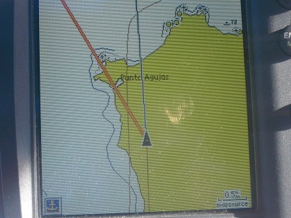
There are reasons why a good mariner uses multiple systems to verify his/her location. This photo of the GPS located at the helm was taken as I was leaving Bahia Concepcion. The little triangle is Si Bon and the yellow area is a land mass known as Punta Aguja. As you can see Si Bon is clearly on land...or at least according to the GPS she is. I was warned about the inaccurate Mexican charts before I left to go cruising, a GPS uses a chart card that duplicates the information from paper charts. Now I'm pretty sure that there is someone thinking right about now "gee Steve, you need to get some better equipment on that boat". Granted that both of my onboard GPS's are 10+ years old, but I also have a brand new handheld GPS and all three GPS's showed the same information and since I have seen similar pictures from other cruisers I have no intention at this time of spending thousands of dollars on new GPS's just so I can have a larger, more colorful picture of Si Bon crossing a point of land. Sooo what do you do? Well the GPS is a still a wonderful tool and one that I still use extensively, but I also do pencil and paper navigation, I use my radar, my depth sounder and of course my eyes (and a good set of binoculars). When you combine all of the sources available there is little chance that you would actually be on the yellow land mass as the pic shows. Well since all three GPS's currently show me in the parking lot here at Marina San Carlos I think I'm going to hop off Si Bon and go ask for a refund on my slip fees, adios.
Comments
| Vessel Name: | Si Bon |
| Vessel Make/Model: | Beneteau 411 |
| Hailing Port: | San Diego, California |
| Crew: | Steve Cook |
| About: | |
| Extra: | I am currently in Banderas Bay (Puerto Vallarta area), where I will be spending the 2012 hurricane season at the beautiful Paradise Village Marina. |
Gallery not available
Who: Steve Cook
Port: San Diego, California